Re: Comment letter in response to NOP for an EIR for Ferry Terminal at the Port of Redwood City
Sierra Club Loma Prieta Chapter’s Bay Alive Campaign, Green Foothills, and Sequoia Audubon Society represent tens of thousands of concerned citizens who care about San Francisco Bay, its ecosystems that provide services to us all, and the wildlife that the Bay supports. We are committed to protection and enhancement of our Bay’s ecosystems and habitats. As sea levels rise and atmospheric river storms become more prevalent, the Redwood City shoreline becomes more vulnerable to wave run-up and flooding.
Our review of the proposed ferry terminal and mixed-use development at Redwood Creek raises substantial environmental and infrastructural concerns. OneShoreline is currently studying possible sea level rise (SLR) infrastructure solutions for this shoreline. If the mouth of Redwood Creek is to provide ferry access to the proposed terminal, it is imperative that the shoreline design around the 9-acre site reduce boat wakes that reverberate toward sensitive wetlands such as Bair and Greco Islands. The construction of appropriate nature-based shoreline infrastructure, to minimize impacts, may require additional setbacks from the shore than the 100’ indicated. If environmental impacts of construction and operation of a ferry terminal, parking lot, and access road are to be minimized or mitigated in this sensitive habitat area, then we feel the best use of the remaining 9-acre site, after the parking lot, is to provide increased setbacks from the Bay for improving the shoreline with nature based SLR infrastructure as well as provide room for flood retention landscaping.
At the same time, as mandated by SB272, BCDC is developing Regional Shoreline Adaptation Plan (RSAP) guidelines for all cities with Bay shorelines. These guidelines will undoubtedly also affect this shoreline infrastructure. In addition, the proposed development site is on Bay fill and as sea levels rise, groundwater is also expected to rise. These Bay fill soils are prone to liquefaction in the event of earthquakes which we all know are inevitable in the Bay Area.
Based on these factors, we believe that this is a poor site for a hotel, convention center, restaurant and office space.
Separate EIRs
Conduct separate Environmental Impact Reports (EIRs) for the ferry terminal and the mixed-use development to address the distinct environmental and infrastructural challenges posed by each project.
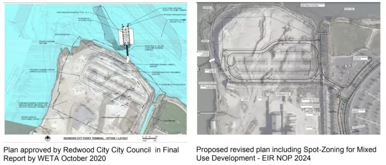
EIR #1 would be for a project level EIR for a ferry terminal on the water and a parking lot on the land that has received public comment and has been approved by the City Council.
EIR #2 would be for a proposal for a Mixed Use Site with significant zoning and General Plan changes in order to modify the heavy industry area of the City. This has implications that could impact the whole City.1 This change is to allow new high density development in an area of the City most vulnerable to sea level rise. These proposed zoning changes have not been previously shared with the Redwood City Council or the public and have not been approved by the City Council.
In our opinion, EIR #2 opens too many issues and raises too many questions that the City needs to evaluate, and the public needs to weigh in on, well before a programmatic EIR could begin to be adequately considered. It involves spot-zoning for these land use changes within the heavy industry and the Port zone. Is this the first step towards intensifying commercial and housing development along this vulnerable corridor? It opens the prospect, once again, of intensified development, such as at the Cargill salt ponds site. This possibility was something WETA raised in its proposal, two years ago, in order to justify the need for a ferry terminal at this location by creating a “Priority Development Area” (PDA) with Transit-Oriented Development, and to better position the ferry terminal for grant funding.
Therefore, there is no reasonable way to create a programmatic EIR for changing the ferry terminal site, currently approved only for a parking lot, and altering it into a mixed use development activity node, without including the growth inducing effects that will need to be considered by the City.
Alternative Development Proposals
Consider alternative development proposals that align with environmental sustainability goals and minimize impacts on the surrounding ecosystem and community infrastructure. A preferred alternative would be the ferry terminal with a landing float in the water and a parking lot on the land, similar to the elements in the plan approved by the Redwood City Council and with nature-based improvements along the shoreline.
Bay Fill and Groundwater Rise
The proposed development is situated on bay fill, which is prone to liquefaction in seismic events. Rising sea levels will also elevate groundwater levels, further destabilizing these soils. This poses significant risks for the construction and long-term viability of a hotel, convention center, restaurant, and office space at this location.
Environmental Impact of Ferry Terminal
The construction and operation of the ferry terminal could detrimentally impact nearby sensitive habitats. Increased boat wakes could harm wetlands, and ferry diesel emissions pose a pollution risk. Comprehensive mitigation strategies must be developed and evaluated to minimize these environmental impacts.
Potential for private ferries
We also continue to be extremely concerned about WETA’s future plans to consider allowing private ferry services to this location, for WETA ferry service economic viability2, in the middle of the largest urban wildlife refuge3, home to endangered species as well as species of special concern.
The project description includes the possible addition of special event service. It does not specifically forbid private vehicles. If private ferries (that are both scheduled and unscheduled) and water taxis (similar to calling an Uber or Lyft water taxi) are allowed to use the dock and terminal facility, this presents a significant problem4. It is important to monitor and enforce speed restrictions of boats as well as to minimize the number of boats through the refuge. It has been clearly demonstrated that it is difficult or impossible to do daily enforcement of speed restrictions of private ferries or water taxis. Officers from the RWC Police Dept. and personnel from the Coast Guard would probably not be watching the site on a daily basis.
Additional boats, especially private ferries and water taxis that are not obeying the speed restrictions, would cause more environmental and safety concerns including more wake waves, potential impacts on rowers and paddlers in non-motorized water crafts, shoreline erosion of Greco Island and Bair Island in the Refuge, increased air pollution, and potential impacts on harbor seals in the area (increase strikes of the seals and increased difficulty for the seals to swim to the Bay to forage for food).
Air Quality
Evaluate the impact of ferry diesel emissions on Ridgway’s Rail and other birds, salt marsh harvest mouse, and other wildlife on Bair and Greco Islands, as well as impacts on recreational users of the waterway. If the project plan will include backup power using diesel fuel, include those emissions in the analysis.
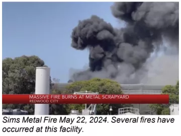
The area is zoned for heavy industry, an important component of the City’s General Plan and of its economic vitality. There is a long history of regular industrial accidents in this area of Redwood City. Evaluate the impact on air quality due to industrial activity at the variety of industrial facilities and of industrial accidents adjacent to the site.5 Sims Metal Fire May 22, 2024. Several fires have occurred at this facility.
Biological Resources
Artificial Light at Night (ALAN)
Due to proximity to Bair Island and Greco Island, night lights from the terminal and parking areas will be harmful to birds and other wildlife in the nearby refuge. Multistory buildings such as a hotel are of particular concern as their lights will stay on at night, lighting the water and the adjacent refuge spaces. ALAN interferes with bird reproduction, feeding and migration. Night foraging creatures will not be able to feed if hotel rooms lights are on at night and shine on the water. Evaluate approaches to and require minimizing ALAN and lighting and use of the site after sundown
Noise
Evaluate the maximum decibel of the ferries and of other equipment at the project site and their impact on birds and other wildlife. Ensure that there are no private boats using the dock, especially at night, such as party boats or special event boats. Evaluate the impact of construction period and noise including pile driving and length of construction time on adjoining habitat and species. Considering the disruption and noise during the construction period, will a significant area of this valuable wildlife habitat be no longer viable for wildlife that now consider it home?
Bird Safe Design
Bird-safe design principles are crucial for protecting avian populations, particularly in areas adjacent to wildlife refuges. These principles aim to prevent bird collisions with structures, which is a significant threat to bird safety. Structures such as buildings, windows, and other man-made objects often pose hazards to birds, leading to injuries or fatalities. Implementing bird-safe designs is essential to minimize these risks and promote a safe environment for birds, especially in areas with high bird activity.
Existing Cliff Swallow Habitat
The northern edge of the site is home to a well-established nesting area for Cliff Swallows. These birds have been utilizing the existing infrastructure for many years during the nesting season. They are the most colonial swallow in the world and in this colony there are approximately 100 nests annually. Swallows are known for their agile flight and reliance on open areas and vertical surfaces for nesting. Their presence indicates a thriving habitat that should be preserved and protected during any development or renovation activities.
Continual monitoring of the swallow population and their nesting success is important. Regular surveys should be conducted to assess the effectiveness of the bird-safe design measures. Adaptive management practices can then be implemented to refine and improve strategies based on observed outcomes.
The Migratory Bird Treaty Act of 1918 (16 U.S.C. 703-712) provides that it is unlawful to pursue, hunt, take, capture, kill, possess, sell, purchase, barter, import, export, or transport any migratory bird, or any part, nest, or egg or any such bird, unless authorized under a permit issued by the Secretary of the Interior. In 2023, Cliff Swallows were added to this list of protected species.
Geology, Soils, and Seismicity
Include information on the soils at the site as well as along the only access road that gives access to the site. Settlement along the two mile access road indicates unstable soils.
Land Use and Planning
Spot-Zoning Changes and Mixed-Use Development
The proposed zoning changes affect the City’s General Plan, and mixed-use development could lead to intensified commercial and residential growth in an area highly vulnerable to environmental risks.6 This raises significant concerns regarding the long-term environmental sustainability and compatibility of land use, potentially setting a precedent for future developments. It is important to note that the site adjoins the City’s heavy industry and the Port, creating incompatible land uses. The heavy industry zoning is unique to Redwood City and is critical for the City’s economy as well as for the economy of the entire region of the peninsula.
Harm to Refuge
This is not an appropriate place for development of hotels, restaurants and offices, where events can take place at night, causing incredible harm to all creatures in the adjacent federal Wildlife Refuge and to the endangered species that have made their home here. This type of land use - a hotel or restaurant that is used at night and that may have rooms or decks overlooking the refuge, where people may congregate, especially in the evenings - needs to be kept far from the refuge.
Economic Viability
The hotel is remote and is too far from downtown services and entertainment venues or for visibility from the freeway. Therefore it is highly unlikely to be economically viable. In addition, the Pacific Shores Office Complex has been slowly acquired and is now approximately 50% owned by Google. This means that the office buildings will not support the restaurant as Google supplies its employees with food in-house. In the North Bayshore area of Mountain View, all the local food service businesses in the area dried up after Google moved in. Therefore a hotel and restaurant are unlikely to be viable in this location. Restaurants adjacent to the nearby Sequoia Yacht Club and Seaport Court office complex, closer to the freeway, have also not survived for lack of business.
Transportation and Access
The development's location presents significant transportation challenges, particularly during peak hours and emergency situations. The intersection at Highway 101 is already the most heavily impacted intersection in the County. The single access road, prone to subsidence and future flooding, could be compromised, impeding emergency response efforts. The transportation section, as laid out in the Initial Study, needs to be expanded to include traffic counts from the Freeway interchange and along Seaport Boulevard. These should be inclusive of projects already in the pipeline like the Harbor View office complex.
Current proposed freeway interchange improvements only plan to bring it up to an acceptable level with no new additions to traffic, and excludes Harbor View. Therefore, the EIR should include anticipated traffic from the Harbor View office complex, which has been approved. and that will, after the intersection improvements are completed, result in the intersection ending up at even a lower level of service than it currently experiences.
Intensifying development far out into the bay, north of Highway 101, is a problem for Redwood City given its vulnerability to sea level rise and ground water rise flooding. The last design iteration of the freeway interchange improvements includes possibly lowering Woodside Road under the freeway, and depending on pumps, potentially exacerbating the emergency access potential in the event of flooding due to storm events. The site is also vulnerable from a safety point of view as it has only one long access road which is on unstable bay fill (the roadway has subsided in a number of places) that is vulnerable to sea level rise, groundwater rise and flooding and being cut off from emergency access in an emergency such as an earthquake.
Hazards and Hazardous Materials
A thorough review of historical and current environmental data is necessary to assess potential contamination risks. Heavy industry in the area adjoining the site and in the vicinity, such as the Sims Metal Recycling facility,7 creates hazards based on records of industrial accidents. (see also Air Quality above) The uncertain composition of bay fill further complicates the suitability of this site for the proposed development.
Include a comprehensive review of historical and current environmental data on hazardous waste sites in the project area, including the former Arco Fuel Terminal site south of the project area. Although Geotracker does not indicate any sites within the project boundaries proper, the former land use for concrete recycling suggests potential contamination with metals and asbestos. In addition, the site is located on bay fill of unknown composition.
The parking area contaminants, including brake dust and tire dust, should not be allowed to drain into the bay. Consider green infrastructure for storm drainage.
Utilities and Service Systems
Analyze the life service of existing utilities and storm water/wastewater systems. Rising groundwater may be poised to inundate portions of the buried utilities off site that are serving the site.
Thank you for the opportunity to provide comments on the scope of the EIR.
Respectfully submitted
Gita Dev, Chair, Conservation Committee
Susan DesJardin, Chair, Bay Alive Steering Committee
Susan Lessin, Legislative Committee
Sierra Club Loma Prieta Chapter
Chris MacIntosh
Conservation Chair
Sequoia Audubon Society
Alice Kauffman
Legislative Analyst
Green Foothills
1Ferry Feasibility Study - Final Report (FFS) Section 9.1 Investment Near the Proposed Terminal – new ferry service could bolster the real estate market and spur development of nearby properties. Existing commercial property within a 15-minute walking distance to the terminal suggests nearly 30 acres of underutilized, low density land uses.
2Ferry Feasibility Study - Final Report (FFS) Section 9.1: Fare schedules – The cost of a long-haul ferry trip may be too high for individuals and could affect ridership, so subsidies from employers may be needed to offset those costs and increase ridership.
Private Ferry Operations – Is there a possibility for privately operated ferries to use the ferry terminal or develop a parallel facility that will benefit from shared landside connections
3US Fish and Wildlife Service: Created in 1972, largely as the result of grassroots efforts by the local community, Don Edwards San Francisco Bay NWR was one of the first, and today remains our nation’s largest Urban National Wildlife Refuge. It covers over 30,000 acres of wetlands, marshes, ponds, vernal pools, and upland habitat in the South Bay. The refuge was established in 1972, largely as a result of grassroots efforts by the local community.
4Ferry Feasibility Study - Final Report (FFS) Section 9.1 Private Ferry Operations – Is there a possibility for privately operated ferries to use the ferry terminal or develop a parallel facility that will benefit from shared landside connections?
5Large fire breaks out at Redwood City metal recycling facility, impacting air quality. As for the Redwood City facility, in 2022, California's Department of Toxic Substances Control ordered Sims Metal to determine the extent of its toxic pollution and clean it up. These include potential toxic releases from the past and any impacts from a fire that occurred at the facility in March 2022......Given the facility's proximity to homes, parks, schools, a trail and parts of a wildlife refuge, the state is concerned about health impacts to nearby populations.
6Ferry Feasibility Study - Final Report (FFS) Section 9.1 Investment Near the Proposed Terminal – new ferry service could bolster the real estate market and spur development of nearby properties. Existing commercial property within a 15-minute walking distance to the terminal suggests nearly 30 acres of underutilized, low density land uses.
7Large fire breaks out at Redwood City metal recycling facility, impacting air quality. As for the Redwood City facility, in 2022, California's Department of Toxic Substances Control ordered Sims Metal to determine the extent of its toxic pollution and clean it up. These include potential toxic releases from the past and any impacts from a fire that occurred at the facility in March 2022....The state department reportedly found elevated levels of lead, zinc and cadmium at the site in addition to a buildup of light fibrous material, which are produced during the metal shredding process, at or near the facility between 2012 and 2019. Without proper management, light fibrous materials can be "uncontrollably dispersed offsite due to wind, rain, or other factors," according to the state's order.