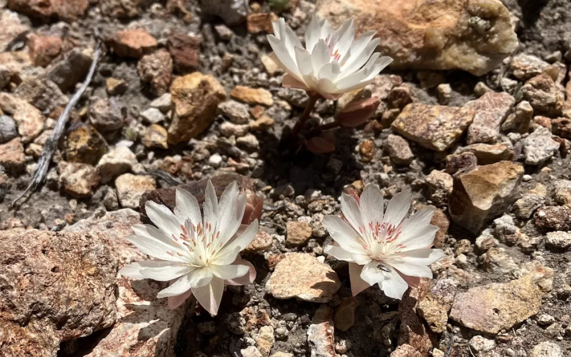
What Exploratory Drilling Looks Like at Sawtooth Ridge

Show All Slides

View of four peaks from the project area. The project is on the Nevada side of the Bodie Hills next to the historic Aurora Cemetery. The peaks from left to right are: an un-named one,  Beauty Peak, Bald Peak, Mt. Chalcedony. The CA-NV state line crosses over the top of Beauty Peak. The main exploration project area is the wooded slope on the east face (right side in this photo) of Mt. Chalcedony. 

View of the project area from the top of Sawtooth Ridge looking southeast. Mt. Hicks in the distance on the left, Aurora Peak with the cell tower to right of it.

View of the main project area in the pinyon-juniper woodland mid August 2023. Two temporary roads were bladed to the two drill sites shown. Hecla Nevada/Klondex drilled at a third site on the slope in September. The project was approved for 16 drill sites. Of those, 13 are on this wooded slope. If the core samples show promising results, they will continue drilling next year.

Over thirty years ago, a company put in temporary roads and drilled in this area exploring for gold. They re-contoured the roads when they were finished by pulling the dirt on the downhill side back up to the road cut to smooth out the slope. This is a section of one of the road scars three decades later. The small pinyon trees in the road scar are just at the point where they will start producing cones. It takes pinyons 35 years to develop pine cones. This generation of pinyons will be wiped out when Klondex re-opens three of these roads.

Google Earth satellite image of the project area in July 1993 showing aerial view of the four road scars. The scars are narrower from vegetation filling in along the edges, but still visible today. The red lines show the roads that were re-opened in the summer of 2023. The yellow pins are the approved drill sites and the green pins are the drill sites that were drilled in 2023.

The pinyon trees are mature, healthy, and produce cones. The forest floor on this slope is covered in fallen pine cones. Pinyon pine nuts are a cultural resource. There are historic trash piles in the area, residue from past mining eras and other cultural resources.

Temporary roads following the old road scars. This is the intersection where two roads split. The road bed is about 10'-12' wide. Measuring berm ridge to berm ridge it is about 15'-17' wide.

Pinyon trees lining one of the temporary roads to a drill pad. Note how the berm on the down slope covers part of the trees.

exposed tree roots along one of the temporary roads.

Upslope side of drill pad #15. 

Drill pad #15 is about 60'x60'.

Sump pit at drill site 15. It is dry. This was the first drill site to be drilled in August. This photo was taken mid October. Water, lubricants, and cuttings from drilling drain into the sump pit. Sump pits are to be ramped to allow wildlife to get out if they go in. This one was sort of ramped to the high water mark, then dropped off steeply.

Drill pad #9 and sump pit.

Sump pit at drill site #9 in mid October. Drilling took place some time in September so the sump pit hasn't dried out yet. It still had water in it mid December. It should be either ramped or fenced to protect wildlife. Luckily, there weren't any animal tracks to it.

View of the berm of rock at the down slope side of the drill pad and trees knocked down to put in the drill pad. Many trees were removed or buried at each drill site. 

The downslope berms are about 22' wide. Some of the trees are half buried in the berm and have broken branches. Will they survive? Are there trees under the rock that are completely buried?

This photo shows the density of trees at the base of the berm. There are an average of 20 pinyon trees in a 30'x30' area around these drill pads. We estimated an average of 75 trees were removed at each of the three drill sites.

Who uses this forest? Bears.

Rabbits. (Rabbit tracks along the road to drill site #15.)

More rabbits. (Rabbit tracks on the ridge top, on Sawtooth ridge.)

And other animals! These are predator tracks along the upper most road scar near the ridge top. Possibly coyote or bobcat. Twice we've smelled cat urine (strong smelling!) at the top of the ridge around an outcrop of rocks. We've also seen clear coyote tracks where the toe nail imprints are clear, deer or pronghorn tracks, and of course, mouse tracks. There could be mountain lion in the area as well. We've heard pinyon jays sometimes in the distance while we've been at the project site.

View of the project area from the top of Mt. Chalcedony, the highest peak on Sawtooth Ridge. The Hecla mine is in the scarred area in the distance on the left.