How Hot Is It?
At a recent meeting, there was surprise by some when I mentioned that the official temperature readings at the airport are taken in the shade. If you think about it, a thermometer left out in direct sunlight would show a much higher temperature than what is reported. This is because the official temperature is just the air temperature.
We all know that being in the shade feels cooler than standing in direct sunlight. The heat radiation from the sun and other sources makes us feel warmer, because it is warming us more than air temperature alone. Interestingly, "cool pavements" designed to reduce surface temperature can reflect heat onto nearby pedestrians, making them feel warmer despite the cooler pavement surface. So, radiative heating can come from more places than the sun.
Humidity also affects how warm we feel. Higher humidity means more water vapor in the air, which hampers our bodies' ability to cool down through sweating. When the air is more humid, our sweat evaporates less efficiently, making us feel hotter. The popular heat index or “feels like” temperature combines humidity and air temperature.
Wind speed is another factor in our thermal comfort. Higher wind velocity can make us feel cooler by increasing the rate at which heat is removed from our bodies. Since 1997, the City of San Antonio along with nonprofit and corporate partners have coordinated Project Cool to provide heat relief to senior residents 60 years of age and older across the city through the donation and distribution of box fans to seniors in need.
The U.S. military combines these four factors—air temperature, radiation, humidity, and wind speed—into a single measure called the Wet Bulb Globe Temperature (WBGT). Although not widely known, WBGT is highly regarded and is used in military training, industrial hygienists, and athletic organizations to determine safe conditions for physical exercise.
WBGT is usually measured with a meter designed to combine these factors. See photo. The meter presents a single “temperature”. Generally, if the value is 80 degrees or less, there is no risk of heat-related health issues. A value of 90 degrees of higher is considered extremely dangerous. The photo shows a value of 82 degrees.
The National Weather Service has a website that can be used to estimate the WBGT of a location. Remember that the actual WBGT depends on very local measurements.
While currently not well known, as temperatures increase, meteorologists are calling WBGT the heat metric of the future.
by Bill Barker, Alamo Group Executive Committee memberEnslaved Cowboys in Antebellum Texas and the Birth of Texas’s Cattle Industry
Our July General Meeting features Ronald W. Davis II, the Witte Museum's Curator of American History, discussing Black cowboys and their contributions to the Texas cattle industry.
Tuesday, July 16th
6:00 pm
Meeting schedule
| Informal get-to-know-you | 6:00 pm to 6:15 pm |
| Announcements | 6:15 pm to 6:30 pm |
| Featured program | 6:30 pm to 8:00 pm |
Venue
William R. Sinkin Eco Centro, 1802 North Main Avenue
Map
Program topic
This presentation will explore the history of Black cowboys from West African ranching to the birth of cattle ranching in Texas. It will introduce the audience to the contributions of West African, English, and Spanish ranching traditions and how the merged in the Caribbean and North America. The talk will culminate with the importance of enslaved labor, as cowboys, along Texas’ Coastal Bend.
About our speaker
Ron Davis is the Curator of American History at the Witte Museum in San Antonio and doctoral candidate in the History Department at the University of Texas at Austin. He is studying under the direction of Drs. Daina Ramey Berry and Walter Buenger. His dissertation’s project, “They Made Me the Best Bronc Rider in the Country, but They Weren’t Trying to Make Me a Rider: Enslaved and Free Black Cowboys in Texas, 1830-1865” examines enslaved cowboys, labor, and resistance in antebellum Texas.
He co-curated the exhibit Black Cowboys: An American Story which was at the Witte Museum in San Antonio until April 2022 and its encore opened in June 2024. He is also a twenty-seven-year veteran of the U.S. military and served in various capacities through five deployments to Iraq and Afghanistan.
Because of these experiences, his research interests also include exploring the lived experiences of black servicewomen and men from the Revolutionary War to Operations Iraqi and Enduring Freedom. In addition, the U.S. Air Force honored Davis with a 4th Air Force Aircrew Excellence Award in 2010 for safely conducting air-to-air refueling with an F-16 Falcon, at night, during a complete loss of electrical power in his aircraft, among other commendations and medals.
The Alamo Group of the Sierra Club holds its general meetings the 3rd Tuesday of most months. They're always free and open to the public.
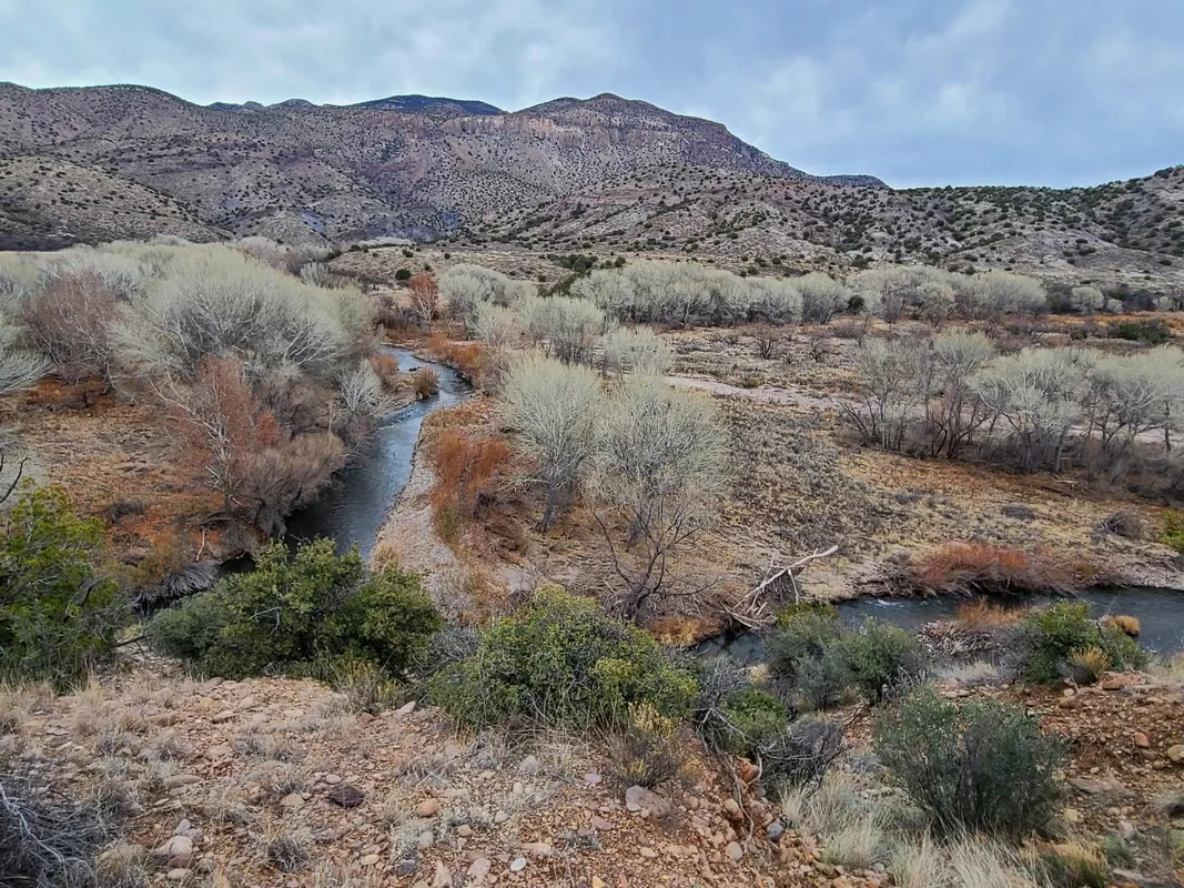
The Nature Conservancy's Gila River Preserve, Southwestern New Mexico
This is thirty miles northwest of Silver City in southwestern New Mexico off US 180. A great area for some hikes with adjacent at-large camping on BLM land also on the Gila River. My visit was early February 2024. From TNC's webpage for the preserve:
The Gila River Preserve protects more than 1,200 acres of the southwest's fragile riparian habitat and the verdant gallery woodland among the Gila River, the last of the southwest's major free-flowing rivers. ... This project area includes the preserve and more than 250,000 acres collaboratively managed by TNC, local landowners, federal and state agencies, and local organizations.
TNC's long-term vision for the preserve is simple: let the river rediscover its natural floodplain and enable new cottonwoods and willows to spring up, providing habitat for neotropical migratory songbirds, especially the southwest willow flycatcher - a species whose population is in trouble. A host of other rare animal species also use the preserve's habitats." Below the text above on the initial page are appealing sections on partnerships and research.
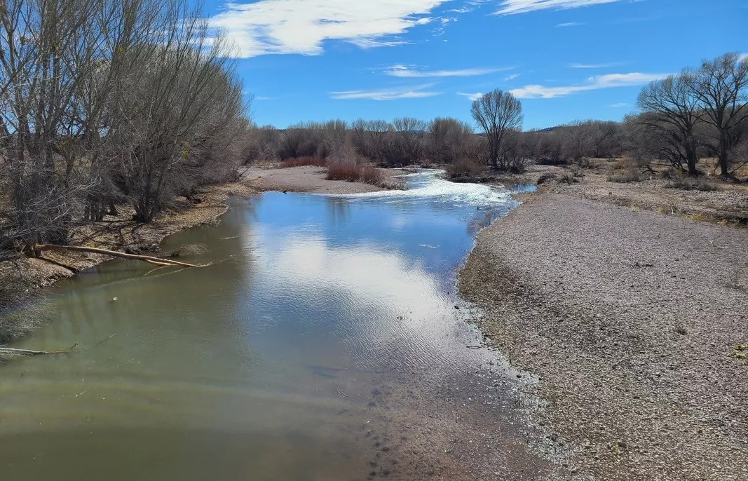
Mogollon Box Trail
TNC's map page for this unit of the preserve has one that shows the route along the west side of the river from the gate at the end of hwy 293, which is 4 miles north from the US 180 turnoff. This bit is apparently included in a 4.25 mile loop crossing the river five times. I just did the out-and-back on the west side, no crossings, picture below. The link above is to one article in a larger compendium "100 Hikes Near Silver City". Geez how many more neat hikes in this area we haven't even heard about?
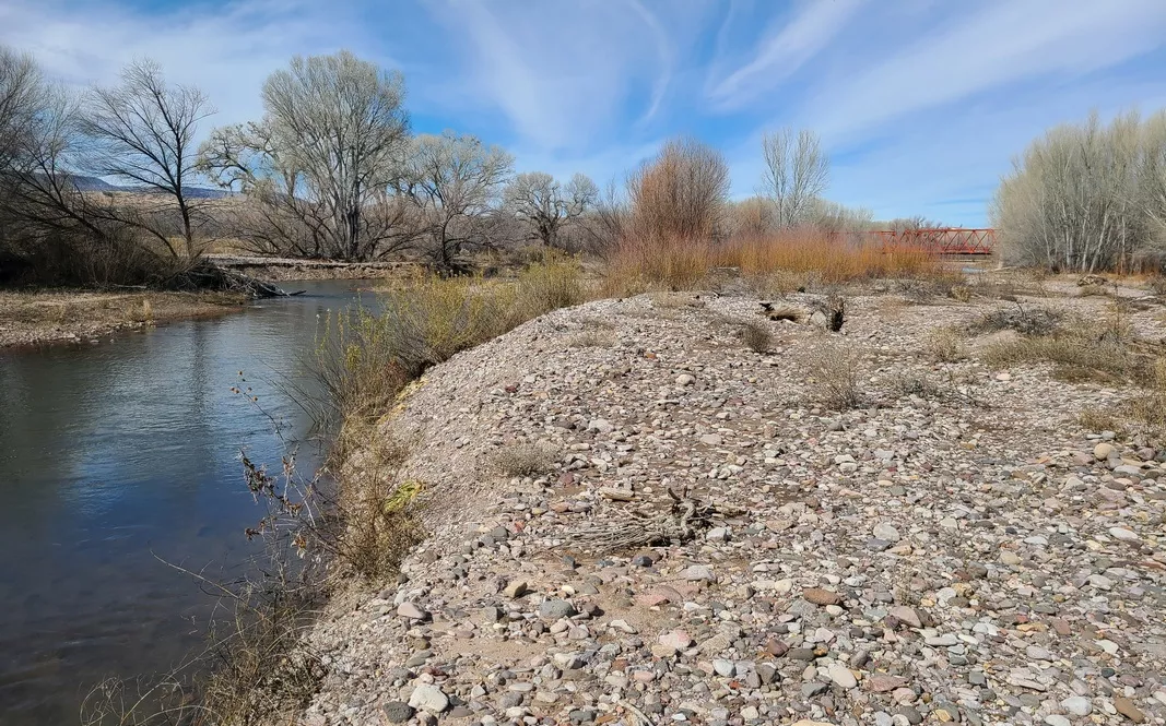
Also: Iron Bridge and Gila River Farm preserve units
From TNC's map page linked above there is Iron Bridge trail (next picture), 1.5 miles on the east side of the river, just west of US 180. The trail crosses the bridge which appears to have been restored. I'm thinking the bridge and traces of an asphalt road in this section of the preserve were part of the original route through this part of the state prior to construction of US 180. About a mile of Gila is included in the preserve here.
And on that page also a bit for Gila River Farm trail. I didn't bother with this, should have. So a farm was purchased or donated to TNC. This 3/4 mile loop includes a section along the river. We could see what nature can do given time with old farmland.
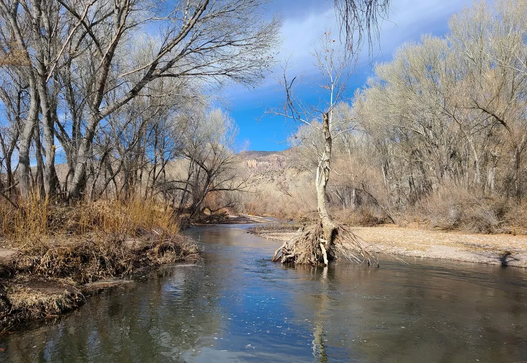
Another river pic and camping
Driving in that 4 miles on hwy 293 we turn east downhill; a bunch of BLM campspots and couple toilets are spaced along the river. The preserve gate is just further north with a few campspots adjacent.
There had been severe flooding maybe in late 2023; the river had used multiple parallel channels through this area I guess due to grading work done for vehicle access and campspot fire safety. Lots of trees down from the flooding captured along the river bank. One toilet had a closed sign about damage due to flooding. One at a higher elevation was open. So I estimated the water level during the flooding might have been about 12' higher than usual.
Lots of fun walking along the river near the campspots, observing little bits about the habitat, and some evidence of H. sapiens having been around. Not much trash excepting one spot where I smelled something nasty, what's that? Found a bag with a rotting deer inside. Wonder if hunting had been legal when it was shot there. I picked and burned most of the trash excepting that carcass. Now realize I could have dumped it out as food for various living things and burned the bag.
The Gila River itself and an earlier article
The Wikipedia article has sections on the geography, history, hydrology and recreation. The river's headwaters are in Gila National Forest north of Silver City, with a couple forks of the river joining near Gila Cliff Dwellings National Monument, about 50 miles due north of the city.
There was an article in this newsletter February 2023 Across Southern New Mexico - Vistas, Geology and History. Couple pics in that looking across the Gila near the national monument.
Lastly, a spot on New Mexico CDT section 6
Twelve miles north of Silver City on US 180 there is a turnoff west on Saddlerock Canyon rd, which goes through part of Gila National Forest. A bit of this section of the Continental Divide Trail follows the road, pretty good though some high clearance spots. Nice with improvised campspots and free firewood.
I passed a couple cars, a woman was looking for her search-and-rescue bloodhound, gave me her card with dog pic and phone number, Missouri Search and Rescue K9. I was driving in a ways, there is a hike north off the CDT (details: HikingProject.com) where I saw a sign about a riparian restoration area there, nice little running spring. Hiking along I was looking for the dog, yelling “dog dog, hey dog!” and whistling. So I was distracted and forgot to take pictures. Later passed the cars and they said the dog was fine, it had found them as was trained to do.
Then I drove back west for a campspot and mistakenly turned south on Blackhawk Canyon rd (we can see these two roads on Google map). Found a nice campspot and realized what I had done. Well how about a little hike up this steep section, get a picture of the car and campspot below. Found a little pile of broken ceramic tile; surely that was thrown downhill from an abandoned cabin. So I climbed up a couple more sections, never saw any other trace of H. sapiens. How did that tile get there? Climbed back down and had forgotten to take pictures again. Surely the bits missed on this trip add up to an excuse for another.
by Kevin Hartley, Sierra Club Life MemberBook! Armadillos to Ziziphus – A Naturalist in the Texas Hill Country
An important, succinct, very readable and inspiring book. Eight sections with 54 chapters on specifics. Published by UT Press, copyright 2023. Hillis is professor and director of the Department of Integrative Biology, College of Natural Sciences, UT Austin. The San Antonio library has 6 copies and Kerrville has one.
The chapters are just a few pages each with some good pictures. As I read many of these chapters thought about how entertaining they were and all the stuff I didn't know. Here are a few examples.
Regards the book title. We have seen armadillos, hopefully alive, not only as roadkill. Ziziphus obtusifolia (SouthwestDesertFlora.com), common name lotebush, is found in much of the southwest plus TX and OK. Now that I've seen some pictures I'll try to recognize it in the future.
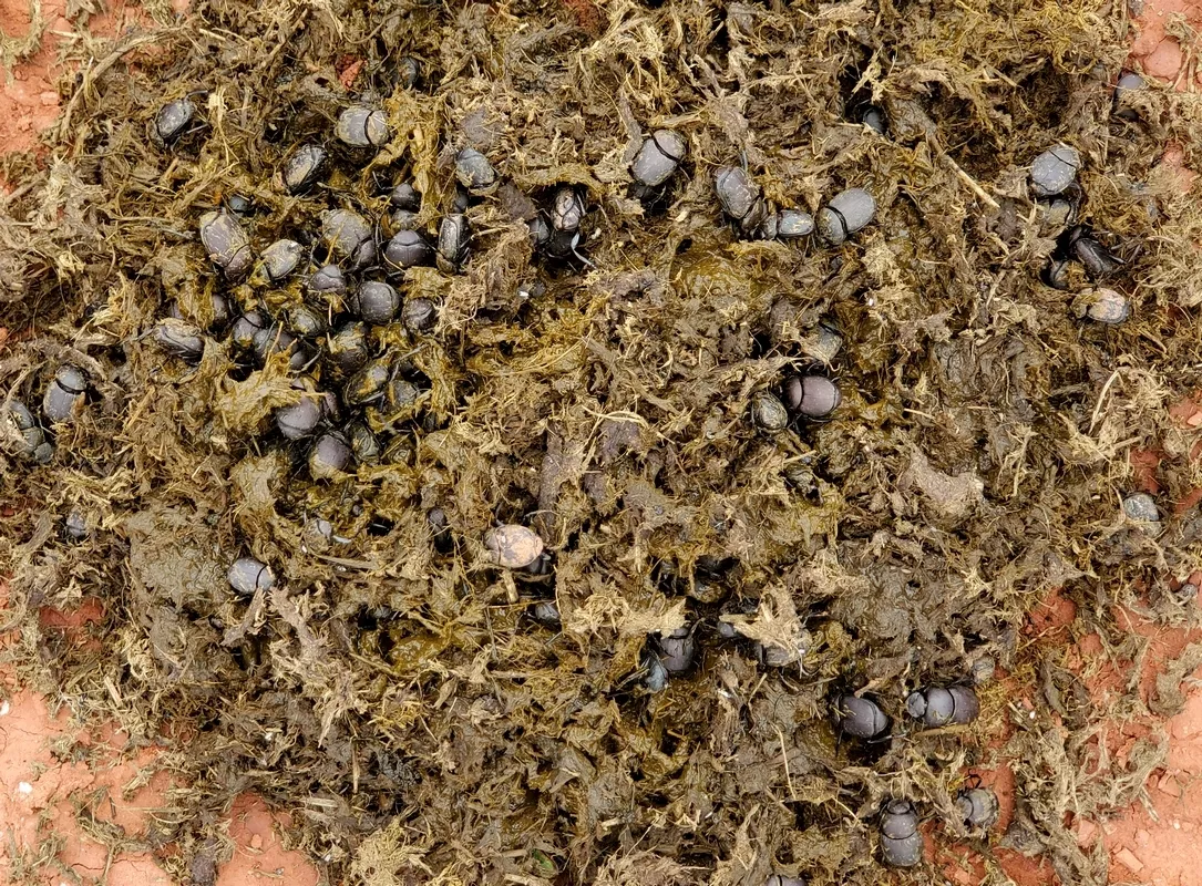
Section IV, Chapter 19: The Noble Life of a Dung-Roller
This is in the fourth section (chapters 17-22), Life of a Grassland. A very educational chapter for city folks.
Hillis says there are 58 species of dung beetles known in Texas. These have various modes of operation, mostly about harvesting cattle dung and burying it for their larvae or living in dung piles. Discussion about the dung-rolling activities.
Then one reason why they are important: their dung consumption reduces habitat for cattle screw-worm flies. A common treatment of cattle for screw-worm infection is ivermectin; which ends up in the dung and kills dung beetles. Using alternatives to ivermectin results in more dung beetles, less dung hanging around and fewer screw-worm flies, which breed and eat in dung piles.
From the book:
...They are extremely beneficial insects. A robust population of dung beetles can quickly remove cattle dung and bury it underground. This greatly reduces the possibility that flies and other pests will breed in the dung, and it removes dung before it can wash in to surface waters, thereby potentially polluting our water supply. The dung buried by dung beetles also fertilizes and aerates the soil.
Hillis recounts a visitor to his ranch being amazed at how well his grasses were doing compared to at his own. The visitor used ivermectin twice a year and didn't have many dung beetles. Hillis didn't use that and would use beetle-safe alternatives if necessary; therefore his ranch was in better shape.
With hiking buddies on a trip in May 2021 saw bunches of dung beetles hard at work taking advantage of buffalo dung at Caprock Canyons State Park, covered in an article in this newsletter March 2022, an additional picture below. We learned a bunch about dung beetles back at the campground with Internet searches but not about the ivermectin problem and the eco-engineering work of the beetles.
20: Where Have All the Quail Gone?
About the decline of particular species, not only quail but also horned lizards and box turtles:
...Both imported fire ants and feral hogs eat the eggs or hatchlings of quail, lizards, and other species that lay their eggs on or in the ground.
Excess populations of raccoons are also a factor due to the hunting of their predators, coyotes and bobcats, and the disappearance of wolves. I found a page at MexicanWolves.org about the eradication of Mexican wolves in the southwest; all gone by 1970.
32: The Future of Hill Country Deer Populations
...Beyond human economic and social interest, deer play an important role in our local ecosystem. If deer are excluding from an area, the changes in the vegetation are quite dramatic.... On the other hand our deer populations are currently too high … We just don't have enough deer predators left to keep the populations in check without intensive hunting.
Section VI: Backyard Biology
This is chapters 34-41. From the beginning of this section:
Rather than trying to sterilize your back yard with insecticides and high-maintenance lawn grass, you may find great enjoyment in attracting and observing some of our fascinating insects and other native animals. Most of our native Texas ants are not human pests, and few will bite or sting unless strongly provoked. Many insects also provide important ecological services, so a healthy garden is also a diverse garden.
If you seek out the smaller and less conspicuous life forms in your back yard, you may be surprised at what you find. Few people take the time to look closely at the intricate beauty of lichens, for example. Once you do, and you understand the complexity of their cooperative lives, you may never stop marveling at them.
35: Ways to Attract and Increase Bird Populations
...Recent studies have found that many raptors, including bald eagles, are suffering from lead poisoning across North America. The lead comes from lead fragments in the remains of game animals that are scavenged by the eagles. This source of poisoning could be easily eliminated if hunters would switch from lead to nontoxic copper bullets.
38: The Ups and Downs of Ants
...Of the 300 or so species of ants in Texas, and about 12,000 worldwide, only a very few cause problems for humans. Most of the others provide important services that sustain stable and functioning ecosystems. ...The decline in Texas horned lizards is partly related to a corresponding decline in their principal food source, harvester ants. Harvester ants have declined in recent decades [due] to imported fire ants and because some of the measures [used] to control fire ants kill harvester ants as well.
Hillis explains to kill fire ants we can simply pour boiling water into the nest, killing many of the ants, particularly the queen and the eggs, then the colony is toast. I should have done that at home recently instead of using insecticide. It is easy to find web pages helping us distinguish fire and harvester ants and their distinctively different mounds.
Section VIII: Restoration and the Future of the Hill Country's Natural Resources
Great intro for chapters 47-54. 47: The Restoration and Benefits of Native Grasses, 48: The Pros and Cons of Brush Control and 54: Six Resolutions for Supporting Native Plants and Animals. This last chapter is a summary conclusion with great ideas that many of us could consider or are already engaged in.
by Kevin Hartley, Sierra Club Life MemberFrom the e-Mailbag
From time-to-time, the Alamo Group receives messages concerning local environmental issues. If you have thoughts on any of these issues, send us a message and we'll forward it to the writer. The views and opinions expressed here are those of the individual authors and do not represent the views or opinions of the Alamo Group or its members.
Turn parking lots into parks, and turn heat into healing
Read this recent op-ed, published June 16th in the Express-News, about a hot expanse of asphalt here in SA turned into a cool neighborhood park.
submitted by Bill B.
Outings: The Call of the Wild
Visit the Alamo Sierra Club Outings page on Meetup for detailed information about all of our upcoming Sierra Club Outings.
The Alamo Sierran Newsletter
Richard Alles, Editor
Published by the Alamo Group of the Sierra Club, P.O. Box 6443, San Antonio, TX 78209, AlamoSierraClub.org.
The Alamo Group is one of 13 regional groups within the Lone Star Chapter of the Sierra Club.
Changed your contact information?
If you're not sure whether the Sierra Club has your current email address, send an email to Member Services with your name and address and/or member ID (see Locating Your Member ID) so they can add your email address to your member record.
Have you moved? Let us know by sending your old address, your new address and your member ID to: address.changes@sierraclub.org.
Go online for the latest news and events
 |