Acadia National Park Confronts a Rising Tide
Rangers are caught between preparing for the annual crush of summer tourists and responding to the climate crisis
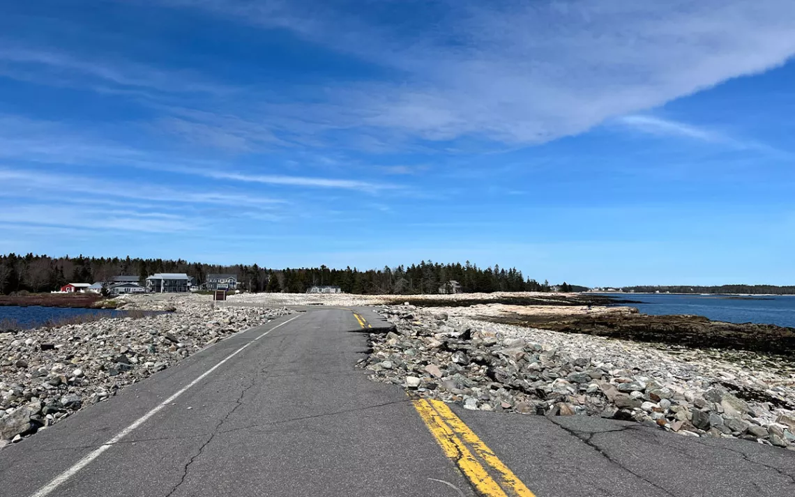
A major storm in January 2024 sent Mount Desert Island's Seawall Road into the Atlantic Ocean, a harbinger of things to come as surrounding Acadia National Park contends with climate change and sea level rise. | Photo by Kyle Paoletta
Over the course of four days in January, a one-two punch of winter storms walloped coastal Maine and destroyed infrastructure across Acadia National Park that rangers are still repairing as they gear up for the millions of tourists who visit every summer. Following nearly identical tracks up the East Coast, each weather system brought hurricane-force winds and a record-setting storm surge of ocean water that flooded, and then flooded again, seaside areas all over Mount Desert Island, which is home to not only the national park but also several towns and a mishmash of state, federal, and private land.
The Gulf of Maine is warming faster than almost any other body of water on Earth, and climatologists estimate the tides around Mount Desert Island are likely to rise by a full foot over the next 25 years. The temporary sea level rise brought on by the January storms offered a peek into what could be a new normal by mid-century, forcing officials at Acadia to confront the reality that restoring the current damage will require a much more rigorous process than merely rebuilding roads and trails, many of which were established over a century ago. It's a situation that illustrates the inherent tension between the two missions of the National Park Service writ large: conservation and tourism.
On the west side of the island, pine trees part to reveal sweeping views of the Atlantic Ocean where a state highway passes over a natural breakwater formation called Seawall. In January, the storms dragged away hunks of asphalt from that roadway and covered a nearby picnic area in rocks and the trunks of 700 or so trees downed by winds gusting in from the ocean. Down the road, one of the Park Service’s interpretative panels had been fully uprooted and tossed aside, as if by a giant. Subsequent storms that rolled over Mount Desert Island during the spring deposited yet more stones in the picnic area, forcing rangers to keep putting up orange cones to dissuade visitors.
When I visited in April, officials at Acadia were still in the early stages of recovery. The facilities crew had its hands full with repairing 1,000 feet of the Ocean Path, a vital trail in Acadia that connects two popular destinations: the island’s only sandy beach and Thunder Hole, where the dramatic crash of waves into a granite chasm draws some of the park’s largest crowds. Fixing the Ocean Path was just one line item in the tens of millions of dollars in damage sustained by Acadia.
The estimated cost of every repair the park will need already dwarfs its annual budget of around $10 million, and the full assessment is not yet completed. (The late thaw of northern New England meant that rangers and volunteers were only able to begin surveying the park’s inland trails in April.)
As park ranger Amanda Pollock drove me around Acadia’s Park Loop Road, she told me that the Park Service’s recovery plans are complicated by its recognition that while the sort of storms that had caused so much havoc this year might have once been labeled an aberration, they are now better understood as a portent of what’s to come. “As the climate changes and as we get warmer temperatures and the sea level rises, science is showing that we're getting more intense storms more regularly,” Pollock said. “We're seeing really high winds. We're seeing an increased storm surge. We're seeing really big waves.”
The combination of Acadia’s vulnerability to climate change and its prominence within the national park system—with 3.9 million visitors, it ranked between Yosemite and Rocky Mountain last year—has made it a test case for the National Park Service’s wider approach to adapting its facilities to the shifting conditions in each park.
Adopted in 2020, the Park Service’s resist-accept-direct framework (known as RAD) lays out three broad categories of potential responses to climate change. While simply rebuilding damaged park facilities might qualify as an effort to ‘resist’ climate change, those proposals must be weighed against other opportunities to either ‘accept’ a shifting coastline or ‘direct’ an anticipated change, such as by restoring a wetland that naturally absorbs stormwater to prevent it from damaging an adjacent roadway. “The ecosystem, the natural resources—that’s obviously the core of our thought process,” Pollock said.
On one of the two portions of the Ocean Path that was destroyed in January, the level gravel trail abruptly collapsed onto the pink granite slabs that preside over the deep blue waters of the Atlantic. Pollock helped me find safe footing down to the rocks in April, then indicated where the facilities team had laid out a new course for the path using string pulled taut between wooden stakes. A few weeks earlier, I’d spoken with Acadia’s management assistant, John Kelly, who acknowledged that getting the Ocean Path in working order for the summer tourist season was a top priority, given the tens of thousands of visitors who typically use it every year. “We’re going to fix that trail,” Kelly said. “That’s the ‘resist.’”
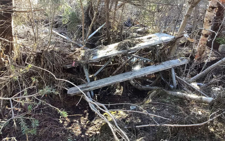
A picnic bench at the Seawall Picnic Area is surrounded by damage from twin winter storms in January 2024. Acadia National Park is on track to repair this area in time for peak summer tourism. | Photo by NPS Photo
Pollock said that the goal is to fully reopen the Ocean Path by Memorial Day—at the time of publishing, she said they’re on track—and that the vast majority of Acadia will remain accessible to the public throughout the summer, even as the facilities team assesses internal damage to the Otter Cove Causeway and the Schoodic Loop Road. But given the placement of the Ocean Path directly above one of the most exposed portions of Mount Desert Island’s shoreline, she stressed that the current work is intentionally temporary, meant to create a “safe, steady baseline” in advance of “figuring out the best mechanism to have that RAD conversation.”
“Ocean Path and the Seawall Picnic Area—they want to get those open to visitation as quickly as possible,” said Lori Schaefer, the communications director for the volunteer conservation group Friends of Acadia. She endorsed the park’s approach, saying “longer-term decisions might come down the road.” The ability of park officials to make those decisions will of course be highly dependent on federal funding. As Pollock put it, “If we plan for a $7 million fix for something, and we get awarded $1 million, that changes what we can do.”
After we made our way over to Seawall in April, a visitor approached Pollock to ask when the picnic area would reopen, echoing a question she’d gotten earlier that day at Sand Beach about when the Ocean Path would be repaired. Each interaction was a reminder that the Park Service’s conservation mission goes hand in hand with its mandate to make reserves like Acadia accessible to the public. When I asked her to attach a timeline to completing a RAD analysis and restoration plan for every part of Acadia that had been damaged by the January storms, from Seawall to the Ocean Path to the inland trails, Pollock summed up the massive challenge now facing her and her colleagues. “It’s going to take years,” she said.