A Swamp for the Senses
The pleasures of Louisiana's Atchafalaya River Basin urge you to draw, dance, or just revel in the natural world. It's easy to forget there's a water war going on.
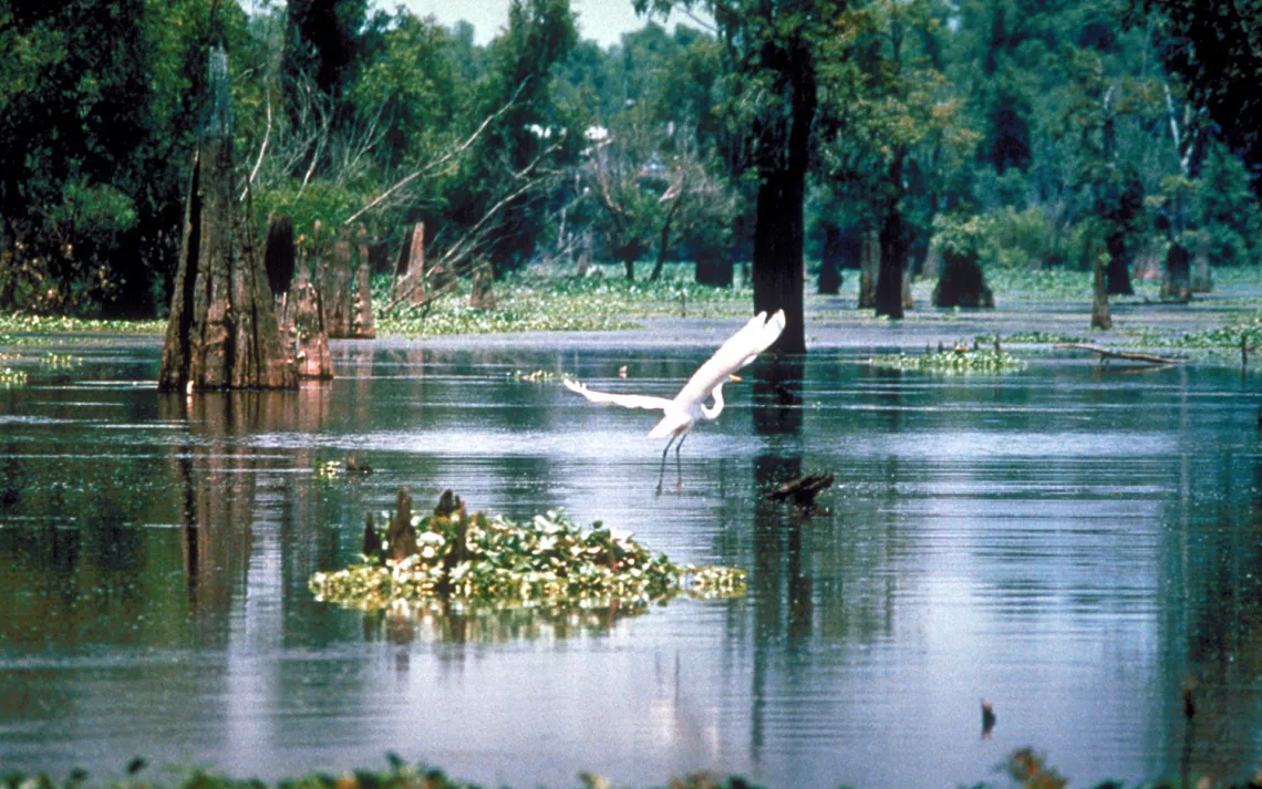
Down an inconspicuous side road on the edge of Lafayette, Louisiana, on the western fringe of the Atchafalaya Swamp, past Cajun roadhouses and raging mockingbirds, you find Lake Martin. A crudely painted plywood sign showing bulbous ibis and spoonbills asks that you not disturb the birds. There are thousands nesting here in the lower-tier tupelo and alder shrubs and the crowns of the overarching cypress. A brief natural moat few would care to wade separates bird and spectator: a duckweed-upholstered stew of guano and gators, who wait log-like beneath the nests, getting fat on nestlings.
Sketchpad in hand, I've settled myself on the edge of the moat, 15 feet from a maze of eye-level nests. Most belong to snowy egrets and little blue herons, who make a fine nautical color combination of crisp white and slate. Many of the birds are already brooding aquamarine eggs, but some are still in the construction phase. I zero in on one hapless egret couple trying to lay a foundation.
A sad beginning: There are two sticks so far, hung vaguely in the crotch of a dead shrub. The female looks at them with an air of discouragement. The male, teetering down slanted twigs, yellow feet like clown shoes, retrieves a spindly prize from the mire, trips and bumbles his way back up and graciously passes the stick to her. But the bird has only her bill to manipulate this awkward baton, which rotates first one way, then the other as she tries to make it fit. The first placement goes wrong, it dangles. And the second. And the third. By the eighth attempt, I can't draw anymore. Teeth gritted, hands in spastic positions, I want to say, Here, give me that thing! I'll do it!
I'm teetering, too-perched on the edge of the Atchafalaya River Basin, more than a million acres of swamp, muck, egrets, and alligators in south-central Louisiana. Compared to the other cypress swamps I've visited, the Atchafalaya is enormous. Why is it still here? We've been filling, diking, diverting, and erasing swamps for two centuries: How did we miss this one? We didn't; we only stopped short of taking it all. This great tract, the largest river swamp in North America, is roughly half its original size but still plenty big enough to get mortally lost in. Though plenty of people would like to "improve" it, the Atchafalaya is most useful in its present state, doing what swamps have always done, absorbing and channeling high water and nurturing crawfish and crabs.
If you're used to topographic relief, you'll get none in southern Louisiana. Low-slung and innocuous-looking, the control structures sit in the middle of a meadowy expanse, resembling modest bridges and culverts more than the crucial floodgates they are. This is where the Army Corps of Engineers went to work when it decided to freeze-frame the lower Mississippi to keep it flowing as it did in 1950.
With the history of a disastrous flood in 1927 and critical high water in later years, they knew they had to act, and in this particular spot the Mississippi is separated from the Atchafalaya by a scant seven miles. For a century levees had been constructed and natural outlets closed until the Atchafalaya River was the only one left to carry off the Mississippi's floodwaters. Out of it they created a massive but highly controlled conduit.
Had I not read John McPhee's Atchafalaya (in his masterful 1989 book The Control of Nature) on the Mississippi's yearnings, and the Atchafalaya's intent to seduce it, these spillways would have looked like another Corps of Engineers boondoggle. They're anything but when the Mississippi is running 2 million cubic feet of water a second, however, as it did in 1973. And sheer volume isn't the only threat. The difference in elevation between water in the Mississippi, the higher river, and in the Atchafalaya, the lower, can reach 20 feet. The force of that gradient exerts massive stress on the structures.
For a few weeks in the spring of 1973, everything and everyone from Baton Rouge to New Orleans depended on the control structures to relieve pressure from the Mississippi: all 11 million people, 110 petrochemical plants, and every jazz band in the French Quarter riffing away below river level. The control structures came within a hair's breadth of failing then; repairs and embellishments are still under way.
I look at the maps and consider the Mississippi in terms of one of its most enduring symbols, the alligator-a gator so huge and old and with such a dangerous tail that she's been put in a cage. This gator can get mad, but no one's seen her really furious here since 1927, though she thrashed in 1973 and almost broke free. She's not happy where she is, and she knows what she wants to do-she wants to join the Atchafalaya.
In a natural world, the Mississippi would continue to lash its tail from side to side in a wide arc from Lafayette to Baton Rouge, forming a fan-shaped delta, shifting her course every thousand years. But since the early 19th century, as soon as people began to appreciate the rich delta silt, they set about guiding the Mississippi with levees to protect their farm fields. Though the river eventually would move again, always seeking the shortest and steepest route to the gulf, they could have kept her confined for another few centuries.
But they never got the chance. The reason for the effort behind the control structures can be traced back to one man and his toys. In the 1820s, Captain Henry M. Shreve developed the powerful shallow-draft steamboat, which could carry dredges or derricks. Shreve, in a move of astonishing hubris, decided in 1831 to dredge a five-mile shortcut across a long meander on the Mississippi, saving 18 river-miles. The river accepted the shortcut and bypassed its old channel. But that bypassed meander turned out to be critical to the whole lower delta. The Red River entered it from the north. Around the bend, a lot of water also exited from it, via the Atchafalaya, heading south.
Shreve's cutoff encouraged what's known as a stream capture. The Red, flowing into the meander, lined up perfectly with the Atchafalaya, flowing out. Back then, though, the Atchafalaya was blocked by a stupendous logjam. Centuries of trees had piled up where it exited: 30 river-miles of hardwood trunks, solid enough to run cattle drives over. Shreve thought he would develop both river channels while he was at it, the Mississippi and the Atchafalaya, so the logjam was dismantled. Everyone tooted their whistles for the brand new water-highway south.
The Red and the Atchafalaya, now effectively one river, represented a shorter and more direct route to the gulf. Alarmingly, on more and more high-water occasions, the Mississippi discovered that route and turned west at the cutoff, joining the Red-Atchafalaya. In the restrained words of the Army Corps of Engineers, "It was apparent that, unless something was done soon, the Mississippi would take the course of the Atchafalaya."
If that happened, in a geological instant New Orleans would become a brackish duck pond, and the factory docks below the cutoff would be ready for bungee-jumpers. Captain Shreve's big idea ended up costing taxpayers about $7 billion, and that doesn't count the century of levee-building that went on before everyone realized levees wouldn't work. Is it fixed? Only the next bout of gator fury will tell, or the next one after that.
From 1831 till the devastating flood of 1927, levees were the accepted solution. Outflow channels into bayous were cut off, one after another. Most engineers believed that, locked behind walls, the river-gator would dig a deep bed for herself and stay put. They were wrong. The Atchafalaya remained as her last escape hatch.
Finally, starting in the 1950s, the levee-builders relented and commenced the control-structure project. About a third of the Mississippi's flow is permitted to join the Atchafalaya through the structures, and the rivers' marriage keeps the great swamp alive. In this very dry year the Mississippi is a quiet gator; she's lounging. Eventually, in some very wet spring, a succession of fat nestlings will fall, such as the Missouri, the Illinois, and the Ohio Rivers. Then she'll be well fed and ready to thrash. The control structures will have to restrain her.
Willowy, scrubbed, and twenty-something, Sierra Club field representative Sarah Craven circulates among the assembled citizenry. Her cool aplomb would do her credit at any Old West poker table. Landscape-architecture professor Charlie Fryling, chair of this public hearing (and the Club's Atchafalaya Committee), is her ally and opposite. He beams, he bounds, a big, freckled, friendly presence. Their colleague Harold Schoeffler, sun-leathered swamp sportsman and conservation chair of the Sierra Club's Acadian Group, is a master of diplomacy.
In the Rocky Mountain West, where I live, an environmental hearing usually means you give your shaky, impassioned testimony under the glare of the apoplectic, anti-environmental "wise-use" folks. Here in southern Louisiana, things seem to have evolved into civility. Tonight's convocation will focus on a long-fought-for accord over the fate of the Atchafalaya Basin. Following up on a carefully considered state master plan, signed into law in 1998, ten agencies have assembled to tell the public what they've accomplished so far.
Are they working toward, as the master plan has it, "a landscape where the complex interrelationships of all components, from the Atchafalaya River to the smallest life forms, will be not only evident but carefully protected and interpreted"? Are they crafting "a place where natural processes are operating on a grand scale, where humans moderate their activities so that they become less intrusive and a reasonable part of, rather than an encumbrance on, these processes"? You could get shot in the West for using language like that. Here, all the agencies, including the Army Corps of Engineers, demonstrate more or less convincingly that this is exactly what they're trying to achieve.
How could these disparate factions have possibly gathered enough mutual sticks to build a nest platform for the Atchafalaya? Right before my eyes are three reasons behind this success. The first (in the form of elaborate maps) is the humbling magnitude of the Atchafalaya Basin itself, and its crucial role in venting the Mississippi River. No one can consider the Atchafalaya marginal or expendable.
The second is the full-house of skills I've already seen in the hands of Charlie, Sarah, and Harold. They've mastered bottomless amounts of data and present it with persuasive informality. The third is that the Atchafalaya is no remote wilderness: It still supports vibrant crawfish and crabbing industries. The people here rely on the Atchafalaya for a sustainable living, as they've done for generations without devastating its riches, and they're not about to give it up.
On an obscure road, Charlie Fryling scatters gravel as he drives us up and over the levee, into the domain of the swamp, which we're about to explore in canoes. Levees guide the flow of the Atchafalaya, but in this case they trace the outlines of a true-to-life floodplain, 15 to 17 miles wide.
The Atchafalaya River has a main channel, dredged and confined in locks for large-scale navigation, but it occupies only a narrow ribbon of the whole basin. Outside that channel, but bounded by the levees, is a labyrinth of fluctuating waterways. Bayous sometimes flow one direction, sometimes the other, depending on local water levels. Interlocking streams and old oxbows add further camouflage. And then there are lakes with no predictable inflow or outflow.
Charlie and Sarah Craven occupy the lead canoe. Getting lost doesn't worry Charlie; his solution is just to head either east or west, and you'll hit a levee-maybe day after tomorrow. Sarah is especially glad to be along; after running a gauntlet of meetings and hearings, she needs water time. The Sierra Club in this region hasn't overlooked the value of celebrating the swamp, and swamp culture. A few years ago, Sarah and others organized the Atchafalaya Heritage Festival in Henderson, a gathering designed to feature swamp-based ways of life and their attendant crafts, stories, history, food, and (of course) music and dancing.
We paddle upstream in a good-size channel for a while, leaving behind the docked shanty boats, decks busy with hammering weekend improvers. Then we turn into a driveway-width water-lane, drifting along under arching tupelos and willows in new leaf, startled only by the emphatic song of prothonotary warblers. Glimpses of them too: sulphur yellow and elegant French gray. The bird is an emblem of the true river swamp, and used to be found as far north as Ontario. But since so few rivers are allowed to flood anymore, its range has diminished. One of only two North American warblers to nest in cavities (which it fills to the brim with soft moss), it will often choose a site just a few feet above the waterline, affording the canoeist an ideal view.
Charlie draws our attention to the banks. These are wee levees, created by the watercourse itself. When water flows over them, it slows down and drops its sediment load, raising the original banks. When the water level falls, as it has relentlessly for the last two years, it lies content within its bed. High water can cover all these subtle topographies, but a swamp veteran like Charlie, or any local crawfisherman, will know when he's passing over a drowned waterway, or crossing a natural levee.
Small posts on the bank warn of a gas or oil pipeline passing beneath us. Under nearly every square mile of the swamp lie these ducts, though water and vegetation have hidden their scars. This is the less obvious face of oil-and-gas development. Everywhere along freight-bearing waterways in southern Louisiana you see mammoth struts, scaffolds, and bulwarks for the offshore platforms. Instead of a geometric grid superimposed on top of the landscape, this plaid of pipeline lies under it. It makes sense. There's no bedrock anywhere around. Beneath us the river-borne sediments are nearly four miles deep, the ideal matrix for a network of shallow trenches.
We're in a lake. Or it's a lake when it happens to be. We idle into forest cul-de-sacs, where big cypress boles emerge from dark water. Bird calls reverberate in the yellow-green canopy, many with Pleistocene sounds that raise the hair on your neck, especially those of the pileated woodpecker and the barred owl, with its demented cackles and whoops in lieu of hoots.
I specifically came here to draw, so my companions park me in the midst of a cypress "island," a grove in the middle of the lake, and depart in the other canoe. In quiet solitude, at once the myriad tiny details press in. That's not cypress bark, it's a tiling of snails. That's not wind on the water, it's gyrating whirligig beetles. That little fog, way up along the cypress bole? A swarm of wild bees around their cavity hive. A watery grass? No, minnows in unison. A slime bubble in floating pond-weed? No, a spider in a waterproof house.
Later, on an outing with Harold Schoeffler, I see a different aspect of the swamp: a true lake, an enormous lake, but one without a distinct shoreline. The open water in the middle gives way to cypress pavilions at the margins, and then impenetrable scrub, still rooted in water. We reach the lake by way of a grimly straight agricultural canal, our errand being to check his crab pots in preparation for the Sierra Club annual meeting. This is one meeting to look forward to: It boasts a crab "boll," and of course live Cajun music and dancing.
Harold's deadpan manner could seem unfriendly, and it's clear he doesn't suffer fools easily. He lets me know that when I point out what seems to be a small island in the middle of the lake. "That's a DUCK BLAHND!" he barks incredulously. But he's a generous walking encyclopedia of Louisiana lore, all delivered in a rich, old-school southern drawl.
We collect crabs, then fish half-seriously in the dappled cypress shade, listening to Harold talk about the many ways the swamp has been misunderstood and misused, from mining to cypress logging to oil extraction. He especially relishes famous follies, like the time Texaco drilled a well in a lake and hit a salt mine underneath, which drained the entire lake and took the drilling rig with it. Harold's way of being in the swamp is purposeful, at least on the surface: to come back with a mess of crabs or fish. The swamp and its solitude are what have gotten him through some hard times in his life, and he's a fierce defender.
Where I grew up in Ohio, we saw crawdads, or crayfish, in the culverted, sewage-scented "creeks" and would no sooner eat one than we would kitty litter. Down here, in far different conditions, the mud-bug is crown prince; his dancing figure shows up on menus, billboards, and welcome banners. And no wonder: He's a delicacy. Lobster plus a freshwater hint of frog legs might be an approximation. The Cajun way of cooking crawfish-rendering the fat out of the heads and thoraxes to flavor sauces, and eating the tail meat in such concoctions as‚ étoufée-brings out its true nature.
The crawfish hunters, as well as the other anglers and crabbers who use the swamp in traditional ways, are powerful voices in the debate over the Atchafalaya Basin. Their idea of how much water is enough doesn't always jibe, however,with other denizens of the place, or with each other. The crawfishermen want more water for the 23 million pounds of crawfish they catch each year.
The big ships also want more, and so do most cities. But Morgan City, mostly an oil town, is a levee-fortified island at the lower end of the swamp, close to the gulf, and it definitely doesn't want additional water. Neither do shrimpers who need shallow-water nurseries. The swamp and its delta are already so weighted down with sediment, and sinking fast, that the salty gulf stands as another predatory gator ready to move in.
We've run out of time for a final expedition into the swamp, so we decide to eat and drink our way through our last day on the bayou. At Cafe des Artistes, in Breaux Bridge, after crawfish for breakfast we pick up a local cookbook written by John Richard "Dickie" Breaux. It contains a well-written account of Cajun history. I knew the origins of the 18th century French Catholic Acadians and their self-imposed exile from Nova Scotia to avoid being forced to join the Anglican Church, but I didn't know how they'd since managed to escape assimilation.
According to Dickie Breaux (who's somehow related to Leon Breaux, dubbed in this cookbook as the "First and Only Eternal Crawfish King"), the levees played a role. Before they were built, the principal bayous carried constant steamboat traffic between the swamp and New Orleans. Full-scale levees finally ended that exchange; the detours and lock systems that came with them in the 1930s were designed for large freighters, not a steady stream of small craft. And it would be a long time before reliable roads would be built in the half-water bayou country.
The Cajuns, already masters of survival, kept to the old ways, in new isolation. When outsiders did venture in, as during the first oil boom, they considered crawfish barbaric fare. The Cajuns learned to keep their "backwater" preferences, both culinary and musical, hidden from strangers.
All that's changed in recent decades. Cajun music, raw and lyrical at the same time, has a huge following, as do crawfish. On Sunday afternoon, with a major storm brewing over the swamp, we find our way to Angell's Whiskey River Landing, near Henderson. We have to drive up and over the levee to get to it, so it's in the authentic no-man's-land, subject to floods. Combination boat-dock, bar, dance hall, and restaurant, it's cool and barnlike inside, sitting on pilings right over the swamp.
The band, "Balfa Toujours," has set up against the windows, in silhouette. Always the accordion, always the fiddle, and this time a woman with a keening, no-frills voice. The rhythms are powerful, and a few couples begin to dance and are joined by about 200 others in the next half hour. The floor is constantly full, the dancers are creative, exalted, tireless. Lots of old folks dance, and the more energetic young ones travel smoothly around them.
There are splendid Cajun men in cowboy dress, wicked and grinning. There are sixtyish single women in tight tops that say "I Live to Dance," never without partners. There are beautiful teens with bored expressions, belied by their enthusiastic jive. There are wild-eyed crawfishermen in wet T-shirts. One of them joins the band, wearing a high-tech washboard, which he plays with spoons.
I had been disappointed not to be able to visit the swamp one more time. But the swamp is very much present right here, embodied in the people who can't stand to be far from it, who define themselves by it-so much so that they refuse to move their gathering places (both social and economic) to the "safe" side of the levee, preferring to take their chances. Maybe some of the exuberance expressed in this room is a direct result of the swamp's persistence, and the horizons opened up by that fact-dancing not as a distraction from hard times and loss, but because there's some kind of future for this way of life.
A vision of "sustainability" has been written into the Atchafalaya master plan. The basin is to be a place where "a diversity of livelihoods will continue . . . where the overriding mood will be a harmonious balance between naturalness and unimpaired ecological processes, and the enlightened and unobtrusive use of the land."
Yes, maybe just a collection of words, flimsy sticks upon which to base a future. And with enough pressure from private interests, the nest platform could collapse. But I've witnessed patience, goodwill, canniness, and stubbornness in the people working to build it, be they activists, drafters of documents, fiddle players, or engineers. A surprising number have shown themselves willing to step forward and say, "Give me that, I'll do it!" May the First and Only Eternal Crawfish King watch over all, and let's dance.
 The Magazine of The Sierra Club
