The relationships people have with their places and landscapes are as intertwined and winding as the rivers that run through them. Whether we consciously acknowledge them or not, these connections manifest in a sense of belonging, cultural traditions, economic relationships, and more. Being familiar with the land, and its features, seasons, and inhabitants creates a bond with a place, influencing how people perceive the world around them and creating a rich tapestry of personal and collective histories.
These deep connections with the places we call home provide us with many benefits: water, food, cultural history, recreation, and health. Access to natural landscapes is linked to many physical and mental health benefits. Green spaces, forests, and bodies of water offer opportunities for recreation, relaxation, and stress relief, contributing to overall well-being.
Forming bonds with our natural places, however, often depends on the accessibility of those places. Because of unfair, racist policies like redlining and economic segregation, communities of color are three times more likely than white communities to live in areas with limited access to nature, with 74% of communities of color in the contiguous United States living in nature-deprived areas. As many as 100 million people do not have a park or greenspace within a 10-minute walk from their homes and nearly 14 million American adults lack reliable transportation of any kind. Lack of access to shade, clean air, and green spaces can lead to health disparities as well. Disadvantaged communities, who have statistically higher rates of health conditions such as heart disease, diabetes, and asthma, are at higher risk from heat stress and smog, which can worsen these conditions.
In a world where concrete replaces forest, inequities build barriers, and access to natural spaces dwindles, our roots to nature wither, and our stories are severed from the landscape, leaving us estranged from the heartbeat of the natural world. In her book "Braiding Sweetgrass," Indigenous scholar and botanist Robin Wall Kimmerer describes the gift-giving between humans and the Earth as reciprocity, an interaction that many people have lost. In addition to ecological restoration, she says, we need ecological “re-story-ation.” That is, we need to re-shape the prevalent story of humans dominating the Earth, and instead, tell the stories of our connections to and relationships with the land. It is these stories, connections, and two-way relationships that may ultimately be the sustainability solutions we need.
Storytelling as a Solution
This begins with retelling the stories of our places and weaving the connections we have with our local landscapes. Scientists, sustainability leaders, and decision-makers are increasingly recognizing that conservation and sustainability are ineffective without consideration of people and place. As action inherently needs to happen somewhere impacting someone, it is integral to weave people and the stories they have with their places into the solutions for complex conservation and community issues.
Community-generated science and solutions-building has also been identified as more effective in addressing such complex issues, including those affecting marginalized populations.
This approach focuses on finding real-world solutions and exploring how landscapes, people, and nature are connected. It looks at how we can keep our environments healthy, how people interact with nature, and how to solve complex problems in different places. This approach, however, is reliant on community participation and multiple modes of knowledge production.
Modernizing Engagement and Connection to Reach Solutions
But how do we engage people where they are? How do we explore the relationships people have with their places? What stories do we collect, particularly in places where those relationships have been severed by modern infrastructure and a legacy of unjust policies like redlining, forced migration, and economic segregation?
Approaches of the past, including in-person ‘town hall’ style meetings, task forces and committees are ineffective and inaccessible for many – these events require securing a meeting space, long-term outreach, and significant commitment from participants, including access to personal transportation. Because of these barriers, in-person meetings end up being conducted infrequently and with little impact or success, generally with low turn-out and a failure to engage underrepresented and marginalized people within the community.
The answer may be online. Step into a world where communities become the architects of their own destiny through online GIS processes. Here, the power of PPGIS isn't just about maps and data; it's about igniting a collective passion for change and harnessing the diverse wisdom of local voices. Imagine a digital realm where interactive tools become the gateway to overcoming public disengagement, revealing the powerful narratives of people and their profound ties to their surroundings. Within this realm, Public Participation Geographic Information Systems (PPGIS), boasting dynamic web-based story maps, emerges as a catalyst, capable of not just shaping public policy, but democratizing decision-making and nurturing collaborative planning processes.
PPGIS is a way to incorporate local knowledge, values, priorities, and stories into maps that guide community and landscape planning. Rather than gathering this information in person, online PPGIS platforms have the capability to glean public input anytime, from anywhere in the world, using interactive maps, digital surveys, and more. It's a revolution in engagement, where technology and storytelling converge to empower communities and ignite meaningful change.
By inviting everyone to the table – from seasoned experts to everyday residents – PPGIS becomes a platform where multiple knowledge systems converge, weaving together the intricate tapestry of local experiences and insights. From bustling city streets to serene natural landscapes, each community's unique story comes to life, shaping solutions that are as vibrant and diverse as the people they serve. With every click and collaboration, PPGIS doesn't just build maps; it builds bridges, forging connections that empower communities to chart a course towards a more sustainable and inclusive future.
How Sierra Club is Leveraging the Power of PPGIS
The Transit to Trails campaign is a partnership between Outdoors for All and Clean Transportation for All that’s aimed at addressing the need for more and environmentally friendly transit options for communities to access public lands and waters.
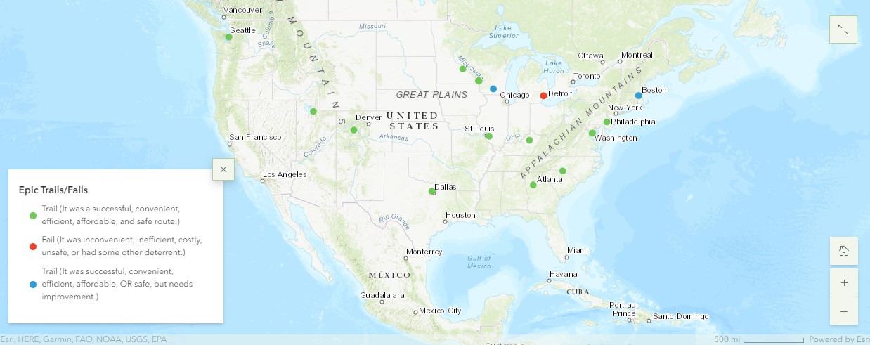
The “Epic Fails and Epic Trails” project is designed as an advocacy tool to highlight both problem areas and success stories to convince policymakers to allocate funding and develop equitable transit solutions that connect underserved communities with nature. This initiative leverages outings, a PPGIS digital story map, earned media, and virtual events to shed light on that disparity. By contributing to the story map, you are helping to build a tool that empowers and engages stakeholders in planning sustainable places. Share your story today.