How Can We Protect Whales From the Shipping Industry?
Researchers at UCSB are using smart sensors to direct shipping traffic

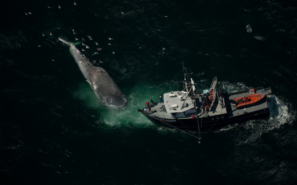
Courtesy of NOAA/Mridula Srinivasan
It is a gruesome image: a magnificent whale wrapped around the bow of a ship, undiscovered until the captain pulls into port. Unfortunately, this tragedy is becoming more common every year.
According to the National Oceanic and Atmospheric Administration Fisheries, an estimated 37 whales collided with ships along the West Coast between 2014 and 2017. And 2018 saw the highest number of fatal collisions in California on record, with 10 confirmed carcasses—half of which were endangered or threatened blue, fin, or humpback whales. Experts say this body count is likely low, as most whales sink or decompose after they die, meaning their carcasses are never counted. All told, an estimated 80 endangered whales are killed annually along the West Coast, and 2019 isn’t showing signs of improvement. In May, 10 dead gray whales were found in San Francisco alone, four of them killed by ships. While gray whales are not presently endangered, they were only removed from the US endangered species list in 1994.
Marine biologists and technology specialists out of the University of California, Santa Barbara, have been laboring to find a way to keep endangered cetaceans safer. “The shipping companies would tell us, ‘Look, if we just knew they were there, we’d slow down,’” says UCSB biologist Douglas McCauley. “They genuinely want to help, so we needed to find a way.”
His team’s solution? Harnessing smart technology to better manage whale traffic.
The project, still in development, began two years ago, when McCauley and fellow scientists at UCSB secured funding from the Benioff Ocean Initiative to start tracking whales in the shipping lane leading to the Port of Los Angeles. One of the busiest ports in the world, its shipping lane runs precariously close to Channel Islands National Park, which is one of the most fertile feeding grounds in the world for whales; many of those it attracts are endangered.

Blue whale | Courtesy of NOAA
The team is working with scientists across the nation and using two distinct methods to track whales: listening and sensing. For the former, McCauley’s UCSB team set up a series of hydrophones (underwater microphones) throughout the Port of Los Angeles that are designed to identify whale sounds and their presence. Hydrophones themselves are not new, but the team’s real-time “listening buoys” have never been used.
McCauley says the challenge here was dealing with a firehose of data: information overload. To sift through all those whale sounds and establish meaning, the team developed computer plug-ins that help distinguish various species.
“Now we can recognize the songs and the calls and the dialects of the whales that are out there,” McCauley explains. For instance, no one had previously been able to listen specifically for blue whales in the Pacific; however, the computer program these scientists are using includes a “call library” that uses algorithms to specifically detect blue whales’ cries.
How do calls get filed? Marine biologist Ana Sirovic monitors the acoustic data from her lab at Texas A&M University, with guidance from biologist Mark Baumgartner at the Massachusetts-based Woods Hole Oceanographic Institute. The two scientists work to verify and summarize pitch tracks before feeding them into the Benioff Ocean Initiative program’s data portal.
Leading the remote sensing piece is Elliott Hazen, a research ecologist for NOAA and assistant researcher for the University of California, Santa Cruz, and Briana Abrahms, another research ecologist for NOAA. In September 2017, they built a forecast system to better detect whales based on oceanographic conditions, using an existing dataset of 104 blue whale satellite tracks collected between 1994 and 2008. Using this data, they created a model that determines the probability of the leviathans appearing on any given day.
“For example, the model may project a good blue whale day,” McCauley says, “assigning a higher probability based on clues like the ocean color, which indicates what is happening at the bottom of the food chain.”
On their own, hydrophone data and remote sensing are not full-proof means of detection—McCauley even notes that the acoustic data collected through hydrophones can mislead scientists, as whales are known to quietly lurk in the water, evading detection. But when combined with Hazen’s forecasting system, the detection model, McCauley says, is “wonderfully accurate.”
Once both sources’ data come together, the listening buoy transmits the information to UCSB through a satellite phone network, pinging McCauley. The whale forecasts come in every day, and in real-time. A control center then translates all that data and breaks it down into an analytical report that ship captains can access via a website (set to launch in 2020) and interpret just as they would familiar traffic signals: green, yellow, and red—the latter means it’s highly likely that whales are in the water, and that ships should thus slow down.
“Every ship captain and company has a preference as to how they want to receive this information,” McCauley says. “We’re trying to make dozens of different notification pathways”—SMS, email, or even VHF radio—"so they can customize [the information] to best work for their company.”
Once the website is up and running next year, everyday citizens will be able to access it too. For nearby Channel Islands park rangers heading out on their patrol boats, McCauley says this could be invaluable. Their end goal, after all, is the same—and more awareness makes for added vigilance, which results in boats slowing down and saving whales.
Courtesy of OSU | Flip Nicklin
And in the event a ship captain opts to disregard whale traffic information, the UCSB team will be well aware—the website will also track ships’ movements.
“We can detect whether they slow down or not,” McCauley says. “We’re academics, and we like giving out report cards. We have the capability to have a look at what grades look like for these companies that are operating in the shipping lane. That’s useful.”
The final round of testing commences this week, when the listening buoys go back into the water. Assuming all goes to plan, McCauley’s team will officially launch this technology in the shipping lane leading to the Port of Los Angeles in early 2020. And then, McCauley hopes to expand its reach to other parts of the country.
“We want to create this as a pilot that can be replicated in other places, like San Francisco,” he says, explaining that the budget for the project is $1.5 million. “The majority of the cost was [research and development]; the aim is to make the system lower-cost and within reach for other ports along the West Coast and beyond.” The ultimate objective is to aid decision-making on the part of everyone in the shipping industry, as well as marine natural resource managers.
McCauley says this project’s measure of success is simple: whale lives.
“Sitting there and merely studying whales felt like an exercise in obituary writing, so this is our chance to get more involved in the change,” he says. “If we see a detectable reduction in the number of ship strikes, we’ll know we did something to help the whales.”