I Hated My Satellite Communicator—Until I Really Needed It
In the deepest wilderness, you can now be in constant communication with the outside world

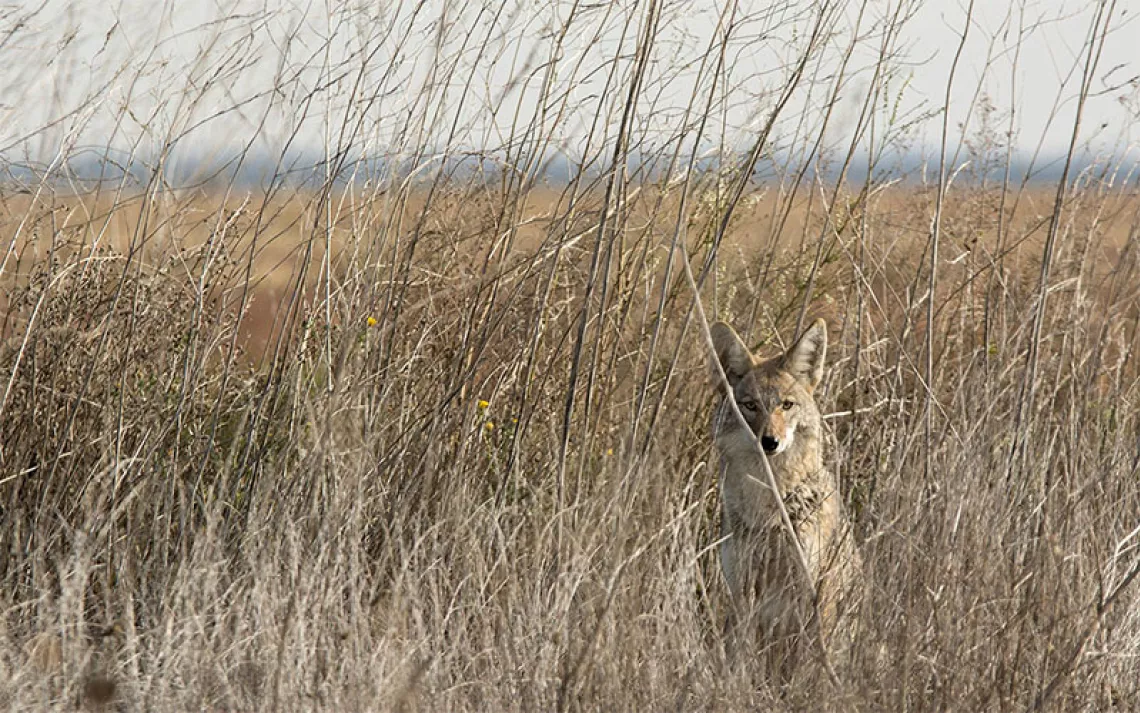
The last wind-free day at the headwaters of the Inukjuak River in Quebec's Tursujuq National Park. | Photo by Conor Mihell
When I venture out of the tent in the wee hours, a cold gust snaps me wide awake; it's startlingly windy for the dead of night. For the past 51 days, my wife, Kim, and I have been canoeing across northern Quebec. Now our eight weeks' worth of provisions are starting to run out, and fighting the ceaseless tundra gales has emerged as our first priority. We're always on standby, waiting for the wind to relent, then breaking camp at ungodly hours when it does, paddling like hell, and stopping when we can move no more. The pattern is exhausting. Back in the tent, the howling wind only seems louder, and I struggle to go back to sleep.
Dawn reveals a desolate scene: The Inukjuak River foams with whitecaps, and mist clots the rocky landscape. Our tent flaps violently, its poles flexing and guylines pulling at their anchor—our 80-pound, overturned canoe. Without speaking, Kim and I hastily release the poles from the strained fabric and seek a more sheltered spot. We burrow into raincoat hoods and duck behind massive boulders, settling on a lumpy, sloping, too-small tent site in the lee of a dripping rock wall. Huddled inside our tent, we can feel the chill of permafrost seeping through the floor.
Our expedition began in late June on the tidal waters of Hudson Bay. Weather-bound days were expected; after 10 days of coastal paddling interrupted by five wind delays, we ventured upstream on an ancient Indigenous route, making numerous portages around cascades and between lakes as we pushed into granite hills and an ever-thinning spruce forest. Deep in the interior of Tursujuq National Park, a 10,000-square-mile protected area, we reveled in the rhythm of 28 days of travel without delay, just the two of us in the greatest wilderness we'd ever known. For a month, I had never felt so strong, like my sinewy body could paddle and portage forever.
But the tenor of our trip took an unexpected turn the day we crested our final height of land to the rocky headwaters of the Inukjuak and paddled north past the treeline. There the incessant Inukjuak winds laid bare the stark division of physical strength and mental fortitude.
Confined now to 40 square feet of flapping nylon, we carefully ration our reading material, play cards, and ponder the projects we'll tackle when we get home. We don't quarrel, but our mood is restless. Finally we reach the saturation point and bring out a cube-shaped electronic gadget from its dry bag—a Garmin inReach satellite communicator, our battery-powered tether to the rest of the world.
I love and hate this device. Sometimes I'm excited to key in pithy 160-character dispatches that will be beamed to the skies, plotted on an online map, and shared with our friends at home on social media. But I'm frustrated when it lags in connecting to satellites, mysteriously deletes half-typed messages, or fails to connect with the smartphone that serves as its screen and keyboard. It's like I'm stuck with a clumsy prosthesis. In such moments, I feel severed from my surroundings and returned to the cluttered world I wish to leave behind.

Map by Steve Stankiewicz
Kim's dad, Mark, takes joy in receiving our messages and quickly responding to our queries ("When were musk oxen introduced to the Ungava Peninsula?" and "What is the population of freshwater seals in Seal Lake?"). Thankfully, he draws the line at updating us on current events. But he's keen to provide weather-related advice using an app called Windy, with which he can plot our coordinates and generate precise forecasts. Mark's weather reports often give us a huge advantage: We can plan our days to maximize efficiency and capitalize on optimal conditions.
Swathed in all my layers inside the tent, I'm studying the maps yet again—awkwardly unfolding the sheets on my lap, looking for sheltered passages and shortcuts in the curves and widenings of the river I've long since committed to memory—when Kim announces there's a message from her father. By now Mark appreciates our anxiety. His communications have become impersonal series of numbers, knots, and gusts. Today's message describes an approaching storm with 50-mile-per-hour winds, preceded by a six-hour window of lighter winds starting midafternoon. If the numbers weren't obvious enough, a terse follow-up suggests that we'd better get ready to make tracks.
We count down the hours until the forecasted calm. Then, far earlier than predicted, our senses tingle at the sudden sound of silence. It's thrilling to trust our gut, knowing that many hard weeks on the water have prepared us for this moment. The inReach gets buried deep in a pack, and we break camp in an instant. The anguish we've felt for days disappears as the wind subsides and we become more confident in our decision. Paddles dig deep as we navigate the final stretch of river back to Hudson Bay.
This article appeared in the July/August 2020 edition with the headline "Our Electronic Lifeline."