Welcome to the Muskeg
You can paddle 500 miles through Ontario's labyrinthine swampland without passing beneath a bridge, touching a road, or seeing another canoeist
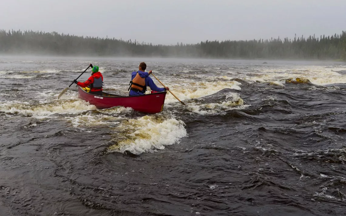
Pas de deux: Teamwork gets Conor and Kim Mihell down one of many rapids on northwestern Ontario's Otoskwin River. | Photo by Conor Mihell
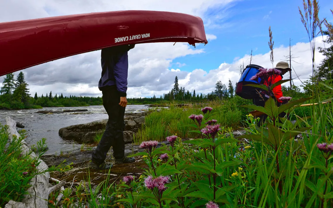
The first of several short portages around the upper Otoskwin’s burbling cascades. | Photo by Conor Mihell
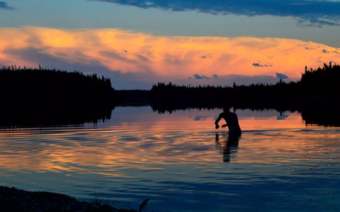
Retreating thunderclouds, a fiery sunset, and an evening swim on the Attawapiskat River. | Photo by Conor Mihell
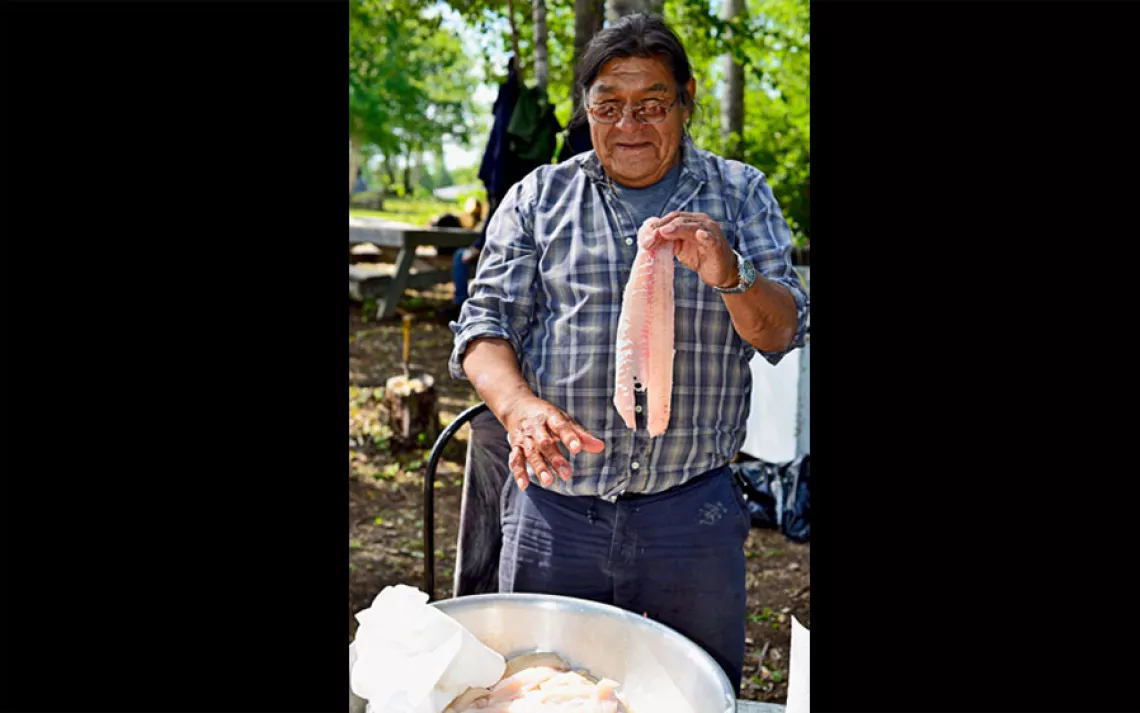
At Neskantaga's summer festival, Ojibwe elder Leo Moonias prepares walleye fillets for the pan. | Photo by Conor Mihell
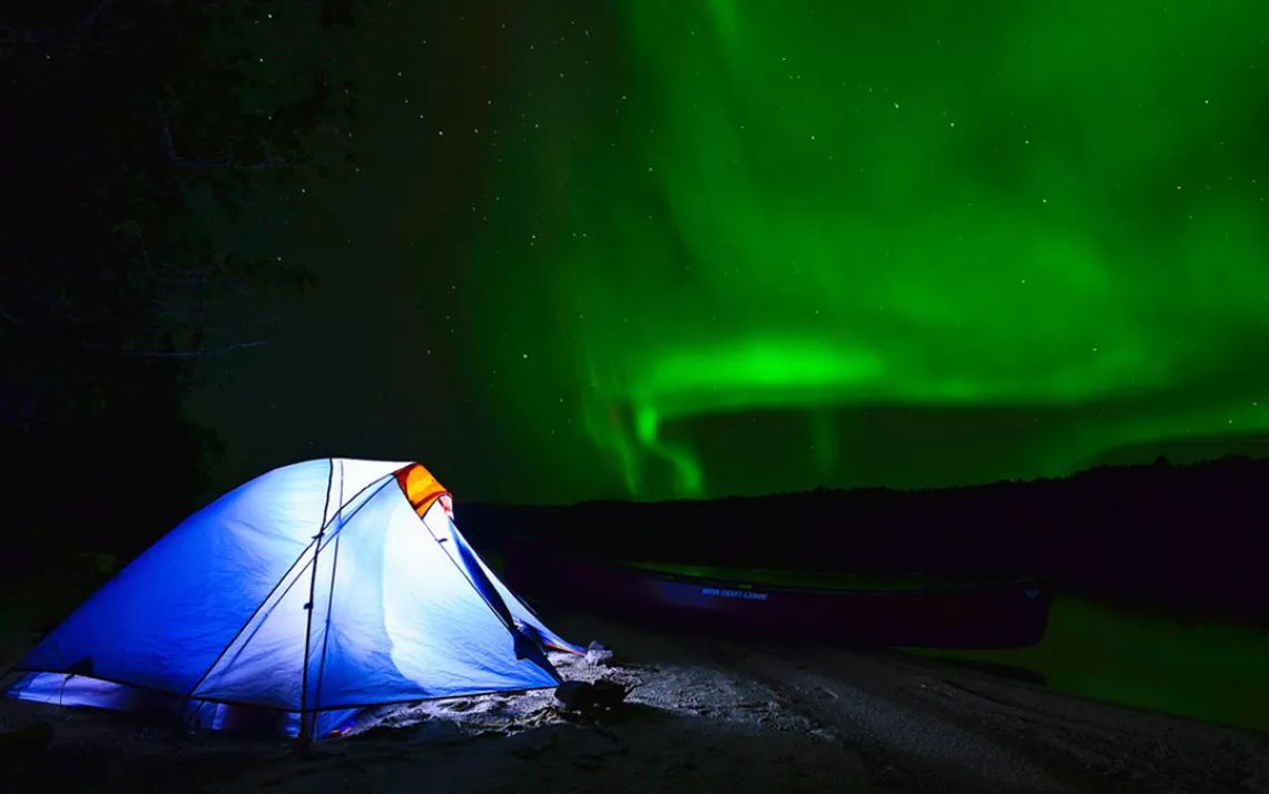
The northern lights shimmer above Attawapiskat Lake. | Photo by Conor Mihell
DAY 1
The boxcar baggage handler tosses our gear out into the midnight darkness. Metal doors slam shut, the train clangs, groans, and screeches back to life, and with a blast of wind, the Trans-Canada is gone, leaving me and my wife, Kim, to ponder the harsh realities of our arrival in Savant Lake, Ontario. The village's dimly lit main street is deserted, and at its lone ramshackle motel, where we've booked a room, the after-hours intercom rings futilely.
Visions of a hot shower and a bed evaporate. There's a gazebo behind the motel, and we set about hauling our gear to it through the darkness. Kim wonders about bears as we unroll our sleeping bags atop prickly indoor-outdoor carpeting and bed down beneath a greasy barbecue. An overfilled dumpster reeks of fish guts. I hand her a bottle of pepper spray and bury my head into my wool sweater pillow.
For the rest of the night, we lie awake listening to the incessant whine of mosquitoes and the thunder of passing trains.
DAY 2
Full of breakfast from the apologetic motel owner, we're shuttled to our put-in point at Pickle Lake, an end-of-the-road town that, like Savant Lake and countless other outposts on this waterlogged edge of the Canadian frontier, once bustled with mining operations and now clings to sparse seasonal tourism. It's mid-August and we're just the second group of recreational canoeists to paddle the 500-mile Otoskwin-Attawapiskat route this year. We're anticipating big whitewater, sprawling lakes, and intense isolation--the type of country that's open only to veteran canoe trippers with lots of time to traverse it.
Loaded with enough food and supplies to see us through the entire journey, the canoe floats with all the grace of an aircraft carrier. Soon enough, we round a bend, the road disappears, and we're swallowed by Canada's Little North, a labyrinth of lakes and rivers coursing toward the Arctic Ocean.
The Otoskwin breaks into a gallop, overcoming the sluggishness of our heavy canoe. We run our first rapid, entering a sequence of deepwater channels through a field of rocks and curling waves. As if gathering its strength, the river calms and broadens before pouring down a bedrock staircase and through a smattering of islands.
To start an expedition with high-stakes, technical whitewater is more stressful than thrilling. Opaque water renders ink-black rocks invisible, and we find scant evidence of portage trails around even the biggest drops, so we tiptoe downstream, pulling ashore to bushwhack and scout a rapid, make the run, then paddle through a brief pool of still water before doing it all again.
About 10 miles downstream from Pickle Lake, a spear of black basalt pierces another stretch of whitewater. Through a screen of cedars, we discover a clearing just right for our tent. There's an eddy behind the rocks, and almost immediately we spy a bull moose wading 200 yards away in a marshy backwater. It feels good to be on our own again, paddling, portaging, camping, and marking our first night on the map.
DAY 6
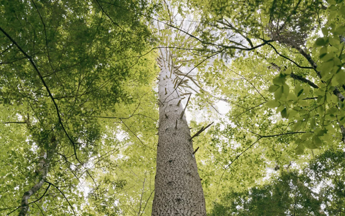
Along the riverbanks, virgin spruce, birch, and balsam fir are draped with lichen. Wolf tracks dot the sand, and portages are obstructed by countless blowdowns.
The occasional signs of human life come as surprises: a red seaplane buzzing overhead, the roar of its prop drowned by the wind; a clearing of jumbled boulders, brambles, and saplings that marks the path of the winter ice road, which is passable by vehicles only when a thick blanket of snow levels the rugged terrain; a disheveled hunting shack built of vertical logs.
They're all clues that we're approaching the Neskantaga First Nation, a village of 300 people on the south shore of Attawapiskat Lake, which you can reach by the ice road, a gravel airstrip, or the water route we've been paddling.
DAY 7
After pitching our tent on a sand spit where the Otoskwin River spills into the west end of Attawapiskat Lake, we cook dehydrated food over a fire and listen to the water, until the whine of outboard engines punctures the silence. A parade of motorized canoes moseys up the lake. In one of the hulking boats, men fish the fast water across from our camp, casting for walleye while they drift with the flow and then gun the outboard against the current to do it again. Shotguns blast in the distance. At sunset, the big canoes motor their catch toward Neskantaga.
DAY 8
Dozens of Neskantagans greet us, insisting that we join them for breakfast at a place called Grandmother Point. We've arrived during the town's summer festival--four days of dances, bingo, and fishing derbies. It's Neskantaga's biggest event of the year.
By an open fire, an old man with a leathery face squints through tinted glasses and tends massive frying pans full of eggs and bacon. We offer him a bag of tobacco and a braid of sweetgrass, and his countenance wrinkles into a smile. He is Leo Moonias, a 72-year-old Ojibwe elder. He serves us a greasy breakfast, and his nephew, Derek Moonias, insists that we stick around for dinner--a village feast of walleye and sturgeon. "You owe us nothing," scoffs a local when we attempt to pass him $20 for the meals. "Stay and eat. We're not stingy."
Throughout the day, we drink countless Styrofoam cups of potent, lukewarm tea and hear stories about life in this watery wilderness. Derek recalls the morning last fall when Leo told him they were taking a multiday canoe trip that very afternoon. For one reason or another, Derek says, the old man decided this was the day to load up a wood-and-canvas boat and descend the Attawapiskat River--following the same route we plan to embark on tomorrow.
Neskantaga roughly translates to "a place on a point where it's easy to snare rabbits." But the town has outgrown its name. Snowshoe hare is no longer a key part of the native diet, just as trapping, Leo's longtime calling, has fallen out of favor because of the decline in the fur market. Today, those Neskantagans not fortunate enough to be employed by the community as administrators or laborers head to Thunder Bay and elsewhere in search of work.
Leo fondly remembers winters spent on his trapline, which stretched into a mosaic of lakes and small rivers north of Attawapiskat Lake. Stalking beaver, marten, wolf, and lynx was his life, a way to make a living and sustain ancient bonds with the land. But now, amid one of the largest wilderness areas in North America, so-called nature deficit disorder afflicts Neskantaga's youth in much the same way that it pervades elsewhere. While most grandparents and some parents still seek sustenance and recreation from the land and water, the youngest generation of Ojibwe prefers to watch television or play on computers, much like children down south.
A gaggle of kids follow us through the streets asking countless questions: "How did you get here?" "Why are you canoeing?" "Where do you sleep at night?" "What do you eat in the woods?" They are as mystified by our journey as we are surprised to realize how disinterested they are in the nature around them.
Bigger problems in Neskantaga, as in many remote reserves, are rampant poverty, substance abuse, and physical abuse. Today, the community is putting on a brave face for its summer festival, but tragedy hangs over Neskantaga like a dark shadow. In early April 2013, two suicides in the span of a week prompted the band to declare a state of emergency; last December, Dwayne Moonias, a 29-year-old relative of Leo's, took his own life.
This evening, though, the mood is one of levity. After dinner, we pitch our tent in a copse of cedars and fall asleep to bingo numbers being called out over a tinny loudspeaker in both English and Ojibwe back at Grandmother Point.
DAY 9
Leo and Derek's year-old canoe trip, it turns out, wasn't the traceless experience we'd imagined. With gasoline, fishnets, and firearms piled into a beamy, 20-foot freighter canoe that itself weighed more than 300 pounds, they traveled neither softly nor lightly. We stop for a swim off a point that's been torched by their bonfire and see more evidence of their journey throughout the day. Later, we're glad for the chainsaw work Derek did on a portage trail. As we shoulder our load around the rapid, I try to imagine how they carried their behemoth canoe and everything it held.
No-trace camping apparently isn't part of the Mooniases' lexicon. But I'm somehow not bothered by it. They use the land in ways that are most convenient, making a sustenance lifestyle somewhat less rigorous. This river, its water so clean I've taken to drinking it untreated, runs through an ecosystem that's remained pristine since the last ice age. Woodland caribou, wolverine, and sturgeon--species long extirpated in southern Ontario--thrive here. I like to think that the Ojibwe themselves must be doing something right--not that the land's harshness has prevented humans from achieving critical mass.
DAY 11
By map and compass we navigate the bewildering formations of the Attawapiskat River's headwaters, finally arriving at a stretch that, the Ojibwe say, is home to a trickster otter. The section is called Big Otter Rapids, and, the legend goes, its tenant likes nothing better than to flip the canoes of innocent paddlers. The water seems calm at first, but then we're drawn midstream where the patchwork of rocks, ledges, and waves conceals seams of dark, smooth water. Soon, the river is accelerating around a downhill curve like a roller coaster, its speed and volume overpowering our paddle strokes and flinging us sideways into rows of waves. An explosion of water breaches the gunwale.
"Brace!" I yell. "Brace!"
Kim throws her entire body onto her paddle to support the wallowing canoe. We can't help hooting when we emerge--soaked, smiling, and upright.
DAY 12
Set on a hill, the Mooniases' cross looks more like a miner's claim post than a religious symbol. It's made of squared-off, thigh-thick tree trunks bound together with twine. From the memories of a canoe trip he'd made at age 17, Leo identified the place where his relatives had lived for generations--until a 1905 treaty prompted their transition to sedentary lives on small reserves. Tall aspens indicate that the forest has since filled out, but near the water's edge are the charred remains of another bonfire.
We've come to the place where the various channels and tributaries of the Attawapiskat merge, committing to the pull of arctic tidewater. We paddle deeper into a flat, featureless expanse where the river presents the only navigable route through an otherwise impenetrable muskeg (Algonquian for "grassy swamp"). We've entered a region that could drive massive socioeconomic change in northern Ontario. Beneath the interminable peat bogs, ponds, and spruce just north of the Attawapiskat's course, miners have struck the mother lode: North America's only known deposit of chromite, an essential element in stainless steel. Developers of the deposit, called the Ring of Fire, are promising roads, railways, and boom camps before the decade is through.
But last fall, these plans were derailed, at least temporarily, when Cliffs Natural Resources, a Cleveland-based mining firm with the largest stake in the area, suspended its Ring of Fire project in part because of the prohibitive costs of developing such a remote claim. Though political leaders touted the prospect as "the most promising mining opportunity in Canada in a century," Cliff officials claim the government refused to deliver cheap hydroelectricity and help build a 200-mile corridor to transport materials to market--not to mention provide hasty approval for the project's environmental assessment.
I wonder if it's mere coincidence that the Mooniases' monument also marks the point where a proposed access road would cross the Attawapiskat River.
DAY 17
Kim wields her wide-bladed paddle like a fencer's sword, deftly drawing and prying the bow of the canoe through waves and hydraulics as I follow up with complementary strokes in the stern. Our whitewater canoeing was once an autocratic affair in which I picked the course and barked commands; now we waltz the boat through most rapids in silent ritual, each conditioned by hundreds of days on rivers to anticipate the other's strokes.
Beyond the inviting shores of the Otoskwin and upper Attawapiskat, we struggle to find camping spots, often making do on limestone rubble or scrambling up steep riverbanks to hack a tent site out of the bush. We log long hours in the languorous current, the shoreline a constant wall of earth tones.
We're underwhelmed by the flat topography, and the ever-widening waterway lacks the usual intimacy of a river. But making up for the lack of stunning scenery is the sheer expansiveness of the terrain--and the possibility of traveling 500 miles without passing beneath a bridge, touching a road, or seeing another canoeist.
DAY 19
A whirring helicopter appears in the sky, and we can smell diesel as we paddle by the base of a big box store-size building that sucks millions of gallons of warm, salty groundwater from De Beers's Victor diamond mine and belches it into the Attawapiskat each day. We can only sense the maw of the 600-foot-deep open pit, which is hidden beyond the riverside bluffs and a screen of spindly trees. Signs written in English and Cree, the language of native people in the James Bay Lowlands, outlaw hunting throughout a wide buffer around the mine.
After miles of tedious flatness, we're happy when the river speeds up, funneling over limestone cliffs before surging by cracked slabs and through a maze of islands. These jagged, tree-topped eruptions of rock, the remnants of reefs in a postglacial sea, look like birthday cakes. But De Beers tarnishes the river's climax. We approach an island that's moored like a ship, its prow bisecting chutes of fast water, and make camp within earshot of bulldozers. I sit on the scalloped shoreline as the setting sun pokes through the clouds and bathes the river in golden light, and I relish the sudden, surprising peace when the sound of earthmovers finally ceases for the night.
DAY 22
By now, the synergy Kim and I display in whitewater envelops all aspects of the day. She sets up the tent and prepares our sleeping bags and mats; I cut and split firewood and cook our meals. We simultaneously spot the same pinprick of a black bear foraging on a distant shore; when I glimpse a white wolf sauntering along the clay riverbank, Kim sees its coal-black mate. Throughout the day, we take turns calling out bald eagles in the sky.
Mosquitoes blacken the tent's walls, heralding a humid dawn. We're camped in tall grasses on a teardrop-shaped island set in the middle of the Attawapiskat's broad, lazy flow. Normally such a buggy morning would hurry us along. But today we linger, sipping tea by the water's edge and watching the sunrise. Only after sandflies cloud our bare arms do we load the canoe and paddle the last 10 miles of our trip.
DAY 23
We spend the night in the town of Attawapiskat and in the morning meet John Metat, a Cree elder with a thin mustache and chin whiskers. He calls this area Kattawapiskak--"space between rocks." He grows animated when he speaks to us through a translator about the changes he's observed over the years on his trapline near the Victor mine. The river no longer freezes, animals have changed their habits, and warnings of fish laden with mercury have multiplied. "What's being done is blasphemy," he concludes, "all for the sake of diamonds." Then he zips up his De Beers windbreaker, revs his all-terrain vehicle, and peels away.