Probably not many DPSers [Desert Peaks Section from the Los Angeles Chapter] are aware that by climbing the DPS list they also get a head start on the Great Basin Peaks [Toiyabe Chapter] list as 21 peaks are on both lists. With this in mind, we planned a joint DPS/Great Basin Peaks Section (Toiyabe Chapter) over Labor Day weekend, 2015. We chose two rugged and remote peaks in northwestern Nevada – King Lear and Duffer Peaks. They are both reputed to have class 3 routes to the summit and in terms of remoteness, the nearest town of any size is Winnemucca, almost 100 miles away.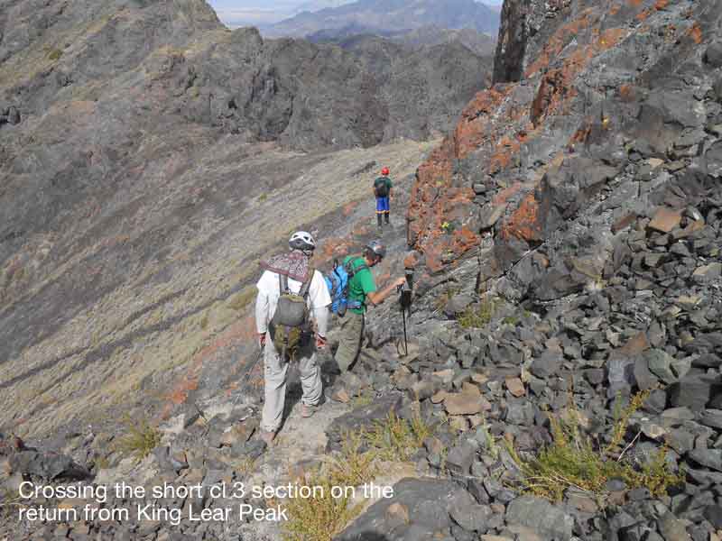
King Lear Peak is a prominent peak in the Jackson Mtns, on the NE border of the famous Black Rock Desert. It can be seen from Highway 80. By co-incidence, our visit coincided with the Burning Man event that same week and we saw a number of dusty vehicles at road stops along the way. King Lear Peak is an unusual mountain in that the top 2000’ is comprised of solid volcanic rock, while the lower parts are limestone. Duffer Peak at 9428’ is located near the Oregon border and is the highest peak in NW Nevada. It also had glaciers on it in the past. Lakes in the Great Basin region are rare, but Duffer has a small group of glacial carved lakes, one of which, Blue Lake, we passed by on our way to the peak.
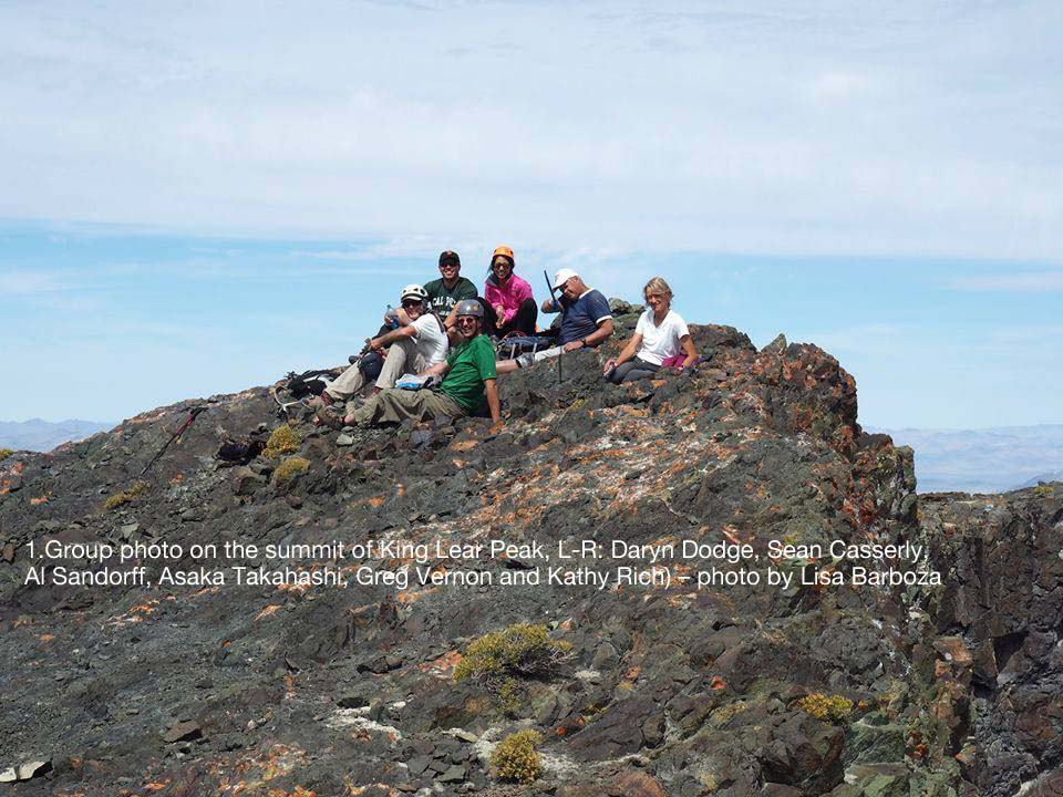
Most of the group met at the McDonald’s in Winnemucca at 6:30 AM Sunday morning for the drive to the trailhead for King Lear Peak. Participants on the trip included Greg Vernon, Lisa Barboza, Sean Casserly, Asaka Takahashi and Al Sandorff.
We chose to use the east side approach to King Lear, as described in Brad Boester’s 2013 report on Peakbagger.com. We headed north on Hwy 95 from Winnemucca and then west on signed Jungo Road for 43 miles. We then turned right and headed north on the signed and graded Bottle Creek Road for 16 miles to a Y junction with Trout Creek Road, taking the left fork and driving about 4 miles to a metal "Designated Route" signpost on the left. This marks the beginning of the rough Hi Clearance, 4WD dirt road up Big Cedar Creek. The road ends in 3.4 miles at a fenceline and grassy area marked with a large solitary rock, elevation 5400ft.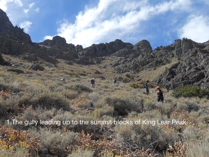
From the road end, we climbed up the slope eventually reaching a gully that headed WNW up under the final summit blocks of the peak. At the top of the gully at a saddle, we circled counter-clockwise on a ledge under the massive, near vertical summit rocks around to the NW side of the peak. Here, we continued south a short distance on the narrowing ledge where we encountered a short section of exposed class 3. Just beyond this section was a nice class 2 ramp heading steeply up to just north of the summit. It then took only a few more minutes to reach the top. From the summit one has 360 degree views - the Great Basin stretching to the north, while to the west was the 100-mile expanse of playa and dust that is the Black Rock Desert. The climb was 5.5-6 miles round trip and 3420’ of gain. We tried to write a famous quote from Shakespeare’s “King Lear” in the register - although we mangled it a little, this is what we wanted to say: “Many a true word hath been spoken in jest”.
Following the climb, we drove north roughly 70 miles to Onion Valley Reservoir so that we could camp near the trailhead for Duffer Peak. There are two ways to drive to the reservoir. We took the easier, but longer, drive through Denio Junction and approached from the north. High-clearance and 4WD is recommended for the last several miles to the reservoir. Six semi-primitive camp sites are located at the reservoir, but there is plenty of open space for camping elsewhere. We shared the campground with numerous range cattle roaming about. Although it was nearly dark when we got there, we managed have a traditional happy hour potluck before turning in for the night.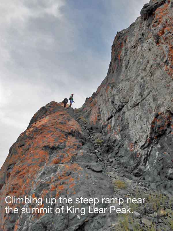
From Onion Valley Reservoir, the road up to the Blue Lakes trailhead was very rough and required both a 4WD and gutsy driving. Sean and Greg were up to the task, so we consolidated into their vehicles for the last few miles to the TH for Duffer Peak.From the parking area it was a short hike on trail to the glacial Blue Lakes. From there the route crosses between the lakes. We then headed into trees and brush towards Outlaw Meadow. With a little searching for cattle trails, the bushwhacking was not bad. At a saddle (elev. 8260 ft.) above Outlaw Meadow, most of the group dropped down and followed a trail at the edge of the meadow. Greg and Daryn thought to stay high and thus try and not lose too much elevation. This turned out to be a mistake because the brush eventually became nearly impenetrable. After the meadow we followed occasional use trails through the trees towards Bare Pass. There is a nice use trail up the east side of the small valley leading to the Pass. There are two summits: the north summit is the Great Basin list peak, but the south summit is the true high point. We climbed both.
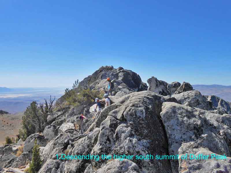
From near Bare Pass, we turned right and climbed the higher south summit first. It was mostly class 2 with a few minor class 3 challenges thrown in. The ridge from the south summit to the lower north summit is technically easy (nearly all class 2). There were two or three candidate boulders for the north summit, one of which required solid class 3 scrambling. From the north peak, we dropped back down into the small valley just north of Bare Pass and returned the way we hiked in. Distance was about 6-7 mi r/t, with 1800' total gain. -- Leaders: Daryn Dodge and Kathy Rich