This Year’s Gulf Dead Zone Forecast to Be One of the Biggest
Floods, spring rains flush millions of tons of fertilizers down the Mississippi River

Photo by Darwin Brandis/iStock
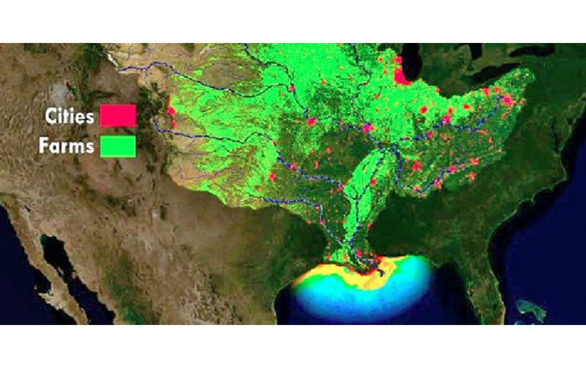
Each summer for at least the past 35 years, part of the Gulf of Mexico dies. That’s because the Mississippi River drains a massive swathe of the Midwest, Great Plains, and southeastern United States and transports tons of excess fertilizers and nutrients into the Gulf, leading to a massive dead zone. This year, as record spring floods flush even more pollutants into the river, the hypoxic zone is forecast to be one of the worst ever, maxing out at around 8,000 square miles—an area larger than the state of Massachusetts.
While agricultural fertilizers, usually forms of nitrogen and phosphorous, can be toxic to fish and aquatic wildlife on their own, that’s not what causes the dead zone in the Gulf. Instead, it’s caused by a process called eutrophication. When excess nutrients are flushed into the warm waters along coastal Louisiana, Mississippi, and Texas, they cause large algae blooms, some of which can be toxic. Those mats of algae also block sunlight from reaching into the sea. But the big problem comes when all that algae dies. The process of decomposition sucks almost all of the dissolved oxygen out of the water near the bottom, leading to large-scale hypoxic zones where fish, shrimp, and other creatures cannot live. Those that can swim or skitter away do, and those that can’t suffocate.
Usually the dead zone dissipates by fall, with the process primed to start all over again in the spring. To get a grip on just how large the dead zone will be each year, government institutions cooperate on a detailed analysis. The forecast is a compilation of predictions created by models from five universities, based on various factors including data from the USGS, which operates 3,000 stream gauges, 50 nitrate sensors, and 35 long-term monitoring sites in the Mississippi watershed. In August, NOAA then sends out a research vessel to measure oxygen levels in the Gulf to determine the actual size of the dead zone to figure out if their estimates were right.

Image courtesy of NOAA
In recent years, their forecasts have been pretty good. But for 2019, there’s a chance the models may be off. “This year’s historic and sustained river flows will test the accuracy of these models in extreme conditions, which are likely to occur more frequently in the future according to the latest National Climate Assessment,” Steve Thur, director of NOAA’s National Centers for Coastal Ocean Science, said in a statement. “The assessment predicts an increase in the frequency of very heavy precipitation events in the Midwest, Great Plains, and Southeast regions, which would impact nutrient input to the northern Gulf of Mexico and the size of the hypoxic zone.”
The largest dead zone since the hypoxia was first measured in 1985 took place in 2017, when heavy spring rains and stream flows dumped lots of nutrients into the river basin, swelling the dead zone to 8,776 square miles. That was well above the five-year average of 5,770 square miles.
So why does this year’s forecast show a smaller dead zone, even though the rainfall and flooding appear more extreme? Don Scavia, professor emeritus at the University Michigan, Ann Arbor’s School for Environment and Sustainability and a member of the multi-institution team that puts together the forecast, says that this year’s floods may not be accurately captured by the models. “The models that NOAA brought together were based and calibrated to the idea that the nutrient load that goes into the rivers in May drives the size of the hypoxic zone. And in a normal year that’s what happens,” he says. But flooding began in parts of the Mississippi River Basin in March and have continued to mid-June, part of the wettest 12 months in US history. The rains have also flushed an estimated 18 percent more nitrates and 49 percent more phosphorous than normal into the rivers, which are discharging 67 percent more water than average. “This year the forecasts may be underestimates. I would not be surprised at all if that’s the case.”
The Gulf of Mexico dead zone is not unique; similar zones exist at the mouths of rivers that drain agricultural areas around the world. The Gulf hypoxic zone, however, is the second largest, behind the almost-19,000-square-mile dead zone in the Baltic Sea. The Chesapeake Bay also has a large annual dead zone that is expected to reach near-record levels this year. Lake Erie, Green Bay, the St. Lawrence River, and coastal Oregon also have dead zones that fluctuate year to year.
Just how the dead zone affects marine life long term in the Gulf is still being studied. But there’s some evidence that the annual period of oxygen deprivation is making shrimp smaller. Economically, the effects are clearer. Studies show the dead zone impacts shrimp prices and takes money from the pockets of fishers who have to travel farther out to catch shrimp during the end of their season, which overlaps with the August dead zone.
Getting rid of the dead zone, however, will be a long and difficult process, if it ever happens. Research indicates that there’s so much excess fertilizer in Midwest soils that even if farmers stopped adding fertilizers to their fields, the eutrophication in the Gulf would persist another 30 years.
And though millions of dollars have been spent on volunteer and incentive-based programs like planting buffer strips and using fertilizer more strategically to decrease the nutrient loads in rivers, Scavia says, the impact has been negligible. “I’ve been doing this analysis since the late 1990s, and the nutrient load in the Gulf has not changed,” he says. “The prognosis is not very good. Unless we do something different, it’s unlikely to change.”
Chances are, things will get worse before any technical or political fixes can be found for the problem. Climate change is expected to increase the average annual precipitation in the Midwest, increasing nutrient input into the river, and warming temperatures in the Gulf are predicted to worsen the hypoxic zones.
Scavia says there are some small things individuals can do, besides pressing for changes in agriculture. Nonagricultural runoff accounts for only about 15 percent of nutrient discharge into the Mississippi River Basin, but keeping lawn fertilizers out of local streams and rivers is a start. The biggest change takes place at the dinner table. Scavia points out that the vast majority of the corn and soy grown in the Midwest goes to beef production. Cutting down on meat consumption, he says, could prevent a drop or two of fertilizer from making the long journey downstream.
 The Magazine of The Sierra Club


