When Extreme Atmospheric Rivers, Storms, and Floods Become the Norm
In an era of increasing weather whiplash between floods and droughts, can we learn to embrace the rains?
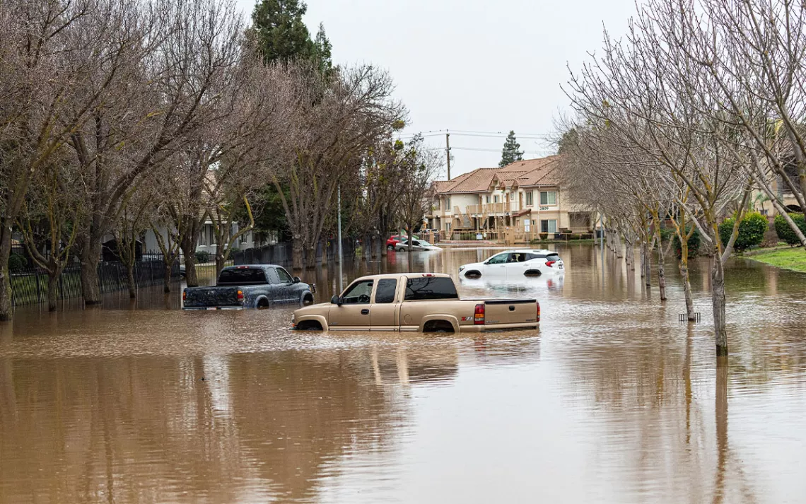
Cars and trucks on a flooded street in Merced, California, on January 11, 2023, after a series of atmospheric rivers pounded the state. | Photo by Andrew Innerarity/California Department of Water Resources
This article was originally published in Hakai Magazine.
In mid-November 2021, a great storm begins brewing in the central Pacific Ocean north of Hawai‘i. Especially warm water, heated by the sun, steams off the sea surface and funnels into the sky.
A tendril of this floating moisture sweeps eastward across the ocean. It rides the winds for a day until it reaches the coasts of British Columbia and Washington State. There, the storm hits air turbulence, which pushes it into position—straight over British Columbia’s Fraser River valley.
Clouds gather and darken. Below, a patchwork of farms and subdivisions sprawls along the Fraser River from its mouth, south of Vancouver, to the eastward mountain slopes, and southeast across the US border. At the center of the valley lies Abbotsford, a city of around 150,000 people nestled in a fingerprint-like depression between two mountains. As the stream of humid air rises toward the peaks, it cools, condenses, and bursts.
To Murray Ned, it sounds like a creek is overflowing outside his home in Kilgard, on a hillside within Abbotsford that’s part of the Semá:th (Sumas) First Nation reserve. Lying in bed, Ned listens to water overflow his rain gutters and splash two stories to the ground. Rain is common in Abbotsford in November, but it’s usually quiet. And it usually lets up.
Over the next two days, nearly a month’s worth of rain dumps here and in other parts of the province. The resulting floods and landslides kill at least six people, rip apart buildings, and buckle roads. In Abbotsford, more than 1,000 homes are swamped and 640,000 farm animals perish as rivers reclaim agricultural land in the floodplain.
But amid the losses, Ned sees something else. The Tuesday evening of the flood—after he has vacuumed water from his mother’s basement and moved the family’s horses to high ground—the deluge stops. Ned settles into a folding chair in his backyard, pulls out a Kokanee lager, and takes in the view. The flood laps knee-high against his horse barn. Semá:th Xó:tsa, Sumas Lake, has returned to the territory.
Once a 6,475-hectare body of water, Sumas Lake brimmed with sturgeon, trout, and five species of salmon—sustaining the Semá:th people and larger Stó:lō Nation for millennia. The lake swelled with fall rains and spring snowmelt, and shrank during summer, leaving fertile ground between the high and low water marks where wild potatoes, berries, and blue camas flowers with edible bulbs thrived. By 1924, though, settlers had converted the lakebed into permanent farmland with a system of dikes, canals, and pumps. But after the 2021 storm, everything in the lowlands is submerged again, from cornfields to the Trans-Canada Highway to a castle-themed fun park.
Most of the floodwaters have come from the Nooksack River. High runoff shifted the Nooksack’s course from its usual east–west flow in the United States and sent it rushing northward into Canada. Stó:lō elders know it can do this. For most of the postglacial period, before natural sedimentation deflected its course, the Nooksack fed the Sumas and Fraser Rivers as well as Sumas Lake. Big floods today can still send the river back north, borders be damned. Water was made to change states. Not so long ago, Sumas Lake had been there to catch it.
As Ned surveys the moonlit water, glistening around horse barns, poultry sheds, and power lines, sturgeon and coho salmon swim old migration routes beneath the surface. “To see Mother Nature threaten [the region] but also see the lake in all its glory again was pretty amazing,” Ned tells me later. Alongside the lake, he sees the possibility of a different future: one that restores space and flexibility for water and that keeps communities safer from the extremes of climate change.
The storm that hit Abbotsford is known as an atmospheric river. These systems are common along the west coast of North America and midlatitudes around the world. They account for one-third to one-half of the annual precipitation in some areas and represent a major source of freshwater for many countries. But studies suggest that atmospheric rivers are becoming more volatile and are delivering water in bigger bursts. Paradoxically, recent storms, including the one in British Columbia, have occurred between some of the hottest and driest summers on record. When they deliver needed rain, it’s too much for parched soils and concrete channels to contain. This pendulum swing between deluge and drought—what meteorologists have started calling “weather whiplash”—will only grow more pronounced as the planet warms.
Ned and other members of Semá:th First Nation have begun advocating to revive at least part of Sumas Lake for the ecosystem and Stó:lō culture, and also for flood control and natural water storage that will make the region more resilient against future disasters. So far, they haven’t gained much traction in Abbotsford, but efforts elsewhere suggest they’re onto something. Perhaps nowhere provides more examples than California, which has long ridden the seesaw between dangerous downpour and punishing drought. Whether through foresight or surrender, communities there are giving up new ground for water and restoring some natural systems, to work with rain when it comes.
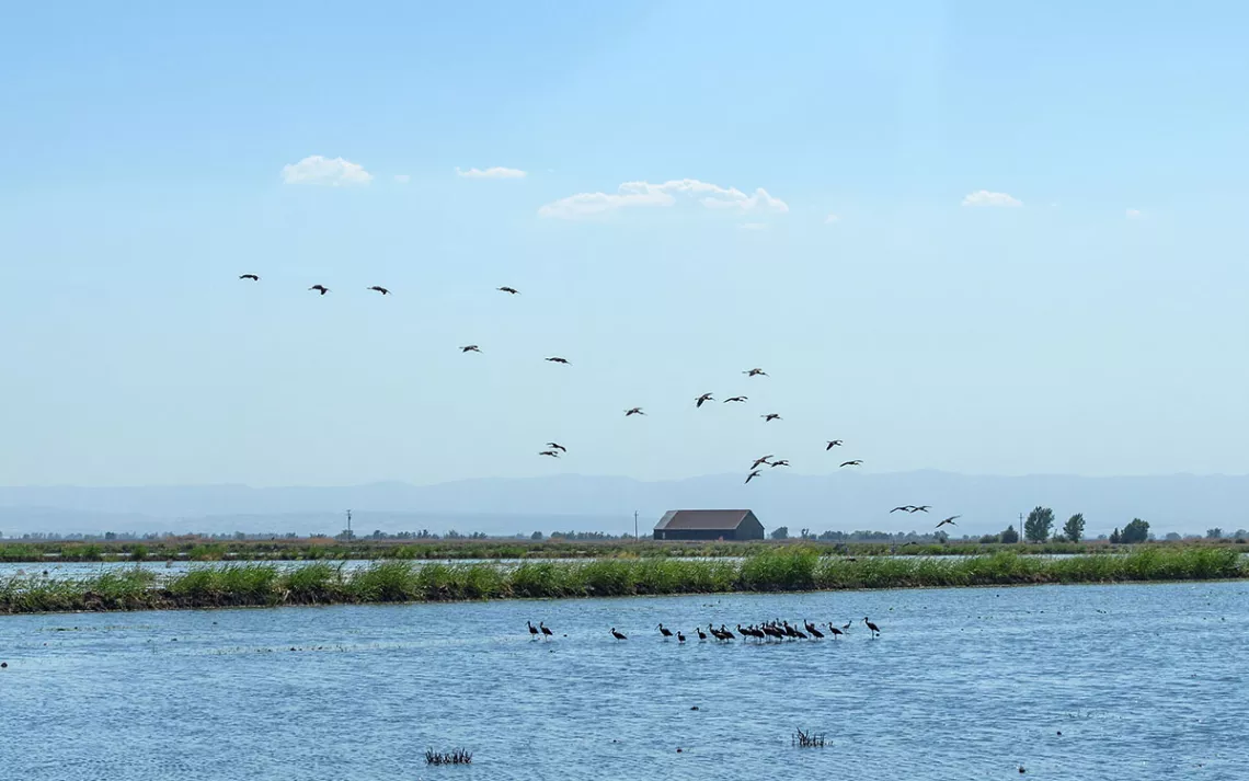
White-faced ibises in a flooded field at Davis Ranches in California’s Sacramento Valley in the summer of 2022. Water from the Sacramento River is piped onto idle farmland here to support threatened shorebirds and waders that migrate along the Pacific Flyway. | Photo by Joshua Asel
*
Sometimes when heavy rain arrives in California, it originated near Hawai‘i. Warm seawater evaporates and fills the air with water vapor, which gets blown across the Pacific until it collides with coastal mountains and falls as rain or snow. By the 1990s, meteorologists believed that a windy layer in the lower atmosphere called the low-level jet likely carried this tropical moisture. But just how much moisture, how warm, how windy, and where exactly it flowed remained mysterious.
In 1998, the National Oceanic and Atmospheric Administration set out to answer these questions with a program called CALJET that deployed sensor-studded planes to fly into West Coast storms. By releasing instruments called dropsondes, which look like mail tubes attached to small parachutes, the research team measured wind speed, temperature, and moisture content at different altitudes. A young scientist named Marty Ralph directed the crew from the flight deck.
Ralph—who founded and now directs the Center for Western Weather and Water Extremes at Scripps Institution of Oceanography at the University of California, San Diego—first got interested in storms as a kid living in Arizona. He’d marvel from his bedroom window at the monsoon rains that made the desert bloom. Later, as a graduate student at the University of California, Los Angeles, Ralph mounted a rain gauge outside his bungalow during one of the state’s worst droughts on record. He was shocked to find 100 millimeters of water in the gauge one winter night; it ended up being half of the local rainfall for the entire year. “I got an early dose of how important individual storms can be in California,” Ralph says.
On his CALJET flights, Ralph got to know these storms more intimately, from their bumpy interiors and thick foggy cloaks to their distinct aroma that wafted through the plane’s air filters. “It smelled tropical,” Ralph recalls, “just sticky and warm.” The scent was coming from far away. In fact, satellite images later revealed that the bands of water vapor stretched a couple of thousand kilometers from the tropics to the coast, and they were as wide as the distance between Vancouver, British Columbia, and Portland, Oregon. But the most impressive part was the moisture, or “juice,” that the dropsondes measured: “The equivalent of 25 Mississippi Rivers of water, but as vapor instead of liquid,” Ralph says.
Once the team crunched the numbers, they learned that their findings lined up with a few landmark studies of the day. One, by researchers Yong Zhu and Reginald Newell, helped coin an evocative term—atmospheric river. “That’s when the lightbulb went on,” Ralph says. “We were studying a river in the sky.”
In the quarter century since the storms got their name, researchers have learned that on average a half dozen of these systems are moving moisture around the planet at any given time. Local monikers point to their origins: The Rum Runner sends juice from the Caribbean to Western Europe; the Pineapple Express is the famous rainmaker that whisks wet air from Hawai‘i to the West Coast. There, atmospheric rivers act like a traveling sprinkler system, spraying up at Alaska in late summer and swiveling down to California by winter or spring.
Combined with the fact that the storms that do come are loaded with more water, this means the wet times will get wetter and the dry times will get drier. More of California’s water is going to pour down in floods.
These sprinklers are usually beneficial, but as in British Columbia, they can become hazardous cascades. During California’s Great Flood over the winter of 1861–1862, a series of atmospheric rivers made it rain for 43 days. The floodwaters formed an inland sea that stretched from the under-construction capitol building in Sacramento to the bottom of the ancient Tulare Lake basin in the Central Valley, and beyond. Thousands of people and one-quarter of the state’s cattle died.
Paleo records from sediments show that atmospheric-river–induced floods of at least that magnitude have occurred in California roughly every 200 years over the past two millennia. Today, even storms lesser than these mega rains cause 90 percent of flood damage along parts of the West Coast.
Atmospheric rivers also pummel the coasts of Western Europe, Africa, South America, and New Zealand. They were responsible for the horrific floods in Pakistan in August 2022 that killed nearly 1,500 people and displaced 33 million more. Their warm moisture is so good at liquefying snow and ice that its thawing parts of Greenland and the Arctic. And because a warmer atmosphere can hold more water vapor, climate change is supercharging these storms. “You have more fuel basically,” Ralph says.
But at the same time that rainfall is intensifying, the droughts that occur are deepening. California—which already faces the most variable precipitation in the United States—will likely see a future with fewer storms overall and longer dry periods between them. Combined with the fact that the storms that do come are loaded with more water, this means the wet times will get wetter and the dry times will get drier. More of California’s water is going to pour down in floods.
“Flooding and drought really are connected,” says Michael Dettinger, a hydroclimatologist who’s been studying atmospheric rivers alongside Ralph since the mid-2000s. “One is just the flip side of the other.”
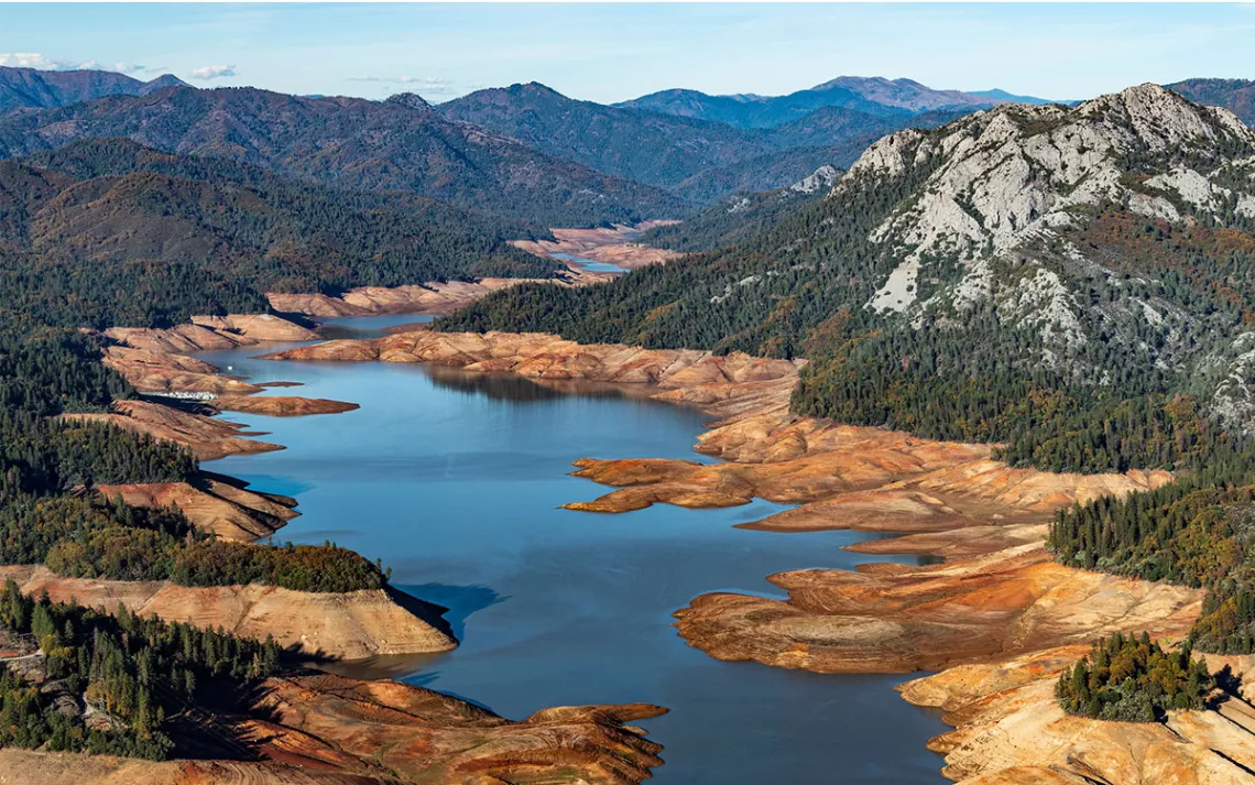
California’s Lake Shasta, which feeds the Sacramento River, reveals bare banks in late October 2021. Amid the driest three-year period since 1895, the reservoir dropped to less than one-quarter of its water capacity. | Photo by Andrew Innerarity/California Department of Water Resources
*
Sacramento in mid-August 2022 is searing. It’s not just the 40°C temperature that’s setting records; California is about to close out its driest three-year period since 1895. In the summer, the Sacramento Valley, part of the larger Central Valley that grows one-quarter of the United States’ food, is usually a checkerboard of gold and green—the gold of spring wheat mixed with glowing green stalks of sushi rice that sway in the warm breeze. But in 2022, Californian farmers planted less than half the amount of rice they projected. That’s because there wasn’t enough water. Jacob Katz squints through his sunglasses at the vast dust bowl that’s resulted. “No one has ever seen this before,” he says, as we drive down a dirt lane surveying the barren fields.
The senior scientist at California Trout, Katz has been working for more than a decade to reconnect the Sacramento River—the state’s largest source of freshwater—to its adjacent floodplains. Like the leaders of Semá:th First Nation to the north, Katz knows that making more room for water could give the landscape and its inhabitants a buffer against weather whiplash.
At the end of the road we’re traveling is a case in point: Dead grass gives way to a watery oasis, glimmering like a mirage in the sun. Dozens of white-faced ibises dip and shimmy their wings while a sandpiper sips a cool drink. Within minutes, an egret glides down from the hazy sky and sinks its black legs into the mud. All of the life in the valley, it seems, is taking refuge in this shallow 55-hectare lake.
The “lake” is actually a research plot at Davis Ranches, a heritage farm near the Sacramento River that’s testing new approaches to water management. One silver lining of the drought is that fallowed farmland can become wildlife habitat, says the farm’s manager, John Brennan, who’s checking on the site with Sandi Matsumoto, water program director for the Nature Conservancy, a partner on this project. “We need to build all the habitat we can to get ready for the dry years,” Brennan says. That’s because habitat can absorb water when it’s available—ideally during floods—and store it in the soil and underground for humans, plants, and animals to tap into during dry spells.
This artificial wetland was designed to assist shorebirds that visit Sacramento during their annual migration from the Arctic to South America on a path known as the Pacific Flyway. Shorebirds have declined by about 40 percent on the West Coast, and they’re particularly vulnerable to drought. But even seasonal habitat like this can make a big difference for birds, Matsumoto says. And it requires far less water than rice farming.
The project is a summer addition to what Davis Ranches and other farms already do for shorebirds and waterfowl in winter. After the rice harvest wraps in the fall, farmers intentionally flood their fields at the peak of the birds’ winter migration, when river water is more abundant. If done at scale, this could reduce the flooding of some infrastructure and communities while allowing more water to soak into the ground, which in turn can help support wildlife and humans at the mercy of drought. “So we have these two things: water insecurity and flood,” Katz says. “But they actually have a common solution—puddles.”
“We need to return to the natural cycles of our system, which include atmospheric rivers, which include drought,” Matsumoto says. “We need to restore our natural systems that are able to deal with those extremes.”
Historically, when rain and snowmelt surged down from the Sierra Nevada—California’s craggy backbone that, in wet years is ground zero for atmospheric rivers—the Sacramento would sometimes swell to 70 times its average flow and spill across a marshy mosaic that connected to a wetland ecosystem larger than the state of Connecticut. Tens of millions of birds and one of the world’s greatest Chinook salmon runs relied upon these floodplains. But after the California gold rush, water engineers constricted the river between 1,600 kilometers of steep levees designed to blast floodwater straight to the ocean. Over the coming decades, settlers replaced the wetlands with farms and other developments.
Katz sums up that history in one word: drainage. “We’re like anti-beavers,” he says. “Everywhere we go, we get water off the landscape as quickly as possible. It’s in our language: ‘drain the swamp.’ What does that mean? It means progress.”
According to a growing body of research, it also means more intense flooding and drought. Instead of allowing water to spread and seep into the earth, squeezing rivers between channels creates a superhighway for flood flows. And sending water away from the landscape means, for the most part, the valley remains parched; below-ground aquifers wait desperately for drips. Add in the fact that agriculture pumps groundwater significantly faster than those aquifers can recharge and you’ve got a very thirsty state. But mimicking the natural flows of water across the terrain could help address both problems at the same time.
“We need to return to the natural cycles of our system, which include atmospheric rivers, which include drought,” Matsumoto says. “We need to restore our natural systems that are able to deal with those extremes.”
She looks across the pop-up wetland where dragonflies circle over neon-green algae. “Fish food!” Katz declares. When sunlight hits the shallow, nutrient-rich water, it blooms with phytoplankton and invertebrates, which then feed fish and birds. Efforts by groups like the Nature Conservancy and California Trout to flood the valley in winter have been supporting dozens of species of birds, which, before dropping off over the past half century, were so numerous they’d black out the sun.
Native fish, like endangered winter-run Chinook salmon, also benefit when they have access to food and shelter on the floodplain. Research shows that juvenile Chinook released into wetlands can grow five times faster than those confined to a channel between levees. They’re more likely to survive their odyssey to the ocean and back as well. “It’s night and day,” Katz says. Straitjacketed rivers with managed flows favor fish like bass that are invasive in California. But natural swings and flood events support the native salmon they’ve shaped, just like they’ve shaped this fertile valley. “Flood doesn’t have to be catastrophic,” Katz says. “It can also be a driver of the productivity and abundance we so value.”
*
Freeing rivers has been catching on as a flood mitigation strategy around North America and the world. And the places welcoming water are seeing added benefits.
In the Netherlands, a program called Room for the River has removed dikes and created side channels for water and fish to meander through 34 riverside communities. Many of these places now offer greater biodiversity and recreation in addition to enhanced flood safety. The new outlets for water act like pressure-release valves when flows are high. During a freak summer flood on the Meuse river in 2021, water levels were the highest ever recorded in some places. But downstream, thanks in part to these Room for the River projects, there was much less flood damage than in previous years, even with bigger flows.
A similar program in Washington State has restored 114 kilometers of fish habitat and created more than 3,700 jobs, ranging from outreach workers to engineers. In the state’s southwest corner, along the Columbia River, locals are also knocking down levees to give lamprey and salmon year-round access to 370 riparian hectares while also protecting infrastructure from flooding.
While California’s plumbing is more complex—it’s one of the most engineered water systems in the world—the state is also restoring some riverways. On the Sacramento, for example, workers are digging 15,000 dump trucks’ worth of earth from a levee so that salmon and sturgeon have a better chance of reaching the floodplain. And now, thanks to growing awareness of atmospheric rivers and precipitation swings, water managers are starting to carry out floodplain projects specifically to boost groundwater: a near-miraculous co-benefit.
The last field we visit at Davis Ranches crunches with dry grass and weeds, another casualty of the drought. But the previous December, an atmospheric river unloaded a good amount of rain. This 24-hectare tract was waiting for the deluge. The ranch piped floodwater from the river into this plot, and its porous soils sucked it up like a sponge. Over a few weeks, the sponge trickled its contents through sand, silt, and gravel into layered pools in the earth: groundwater aquifers. At the same time that puddles were feeding stilts and sandpipers above ground, the water table below was rising.
This process of sending surface water underground is not a new idea, but the drought has given it new urgency along with a new name: managed aquifer recharge, also known as MAR, Ag-MAR, or Flood-MAR. With most river water already rationed among human uses, as well as minimum flows for fish, excess water from atmospheric rivers can be the shock absorber between flooding and drought if allowed to pool on the land instead of charging out to sea. “The only water not spoken for is these flood flows,” Brennan says. “Even in the driest years, we have extra water.”
Since starting the recharge project in 2019, Davis Ranches has captured about 370,000 cubic meters of water each winter. That’s around what 150 US households use in a year, and it’s just from one field, covering only 1 percent of this property. The farm is saving up that groundwater to share with neighbors at a later date, with the goal of leaving more water on the surface for wildlife.
In the most drought-prone reaches of the state, communities are similarly turning to groundwater recharge, often putting pipes and canals set up for summer irrigation to new use during winter to divert flood flows into aquifers. By 2022, local governments in areas where human use has depleted aquifers were required to submit sustainability plans in accordance with a 2014 state law aimed at restoring groundwater. Many of these plans include recharge projects like the one at Davis Ranches but larger.
The California Department of Water Resources (DWR) has already invested $68 million into 42 of these projects, moving one-quarter of the way toward Governor Gavin Newsom’s goal of expanding recharge capacity in the state by more than 616 million cubic meters. That’s the equivalent of adding another large reservoir but underground, safe from heat and evaporation. By some estimates, the sapped aquifers below the Central Valley have space for three times more water than all of California’s reservoirs combined. DWR is now vetting dozens of additional projects aimed at banking water below ground.
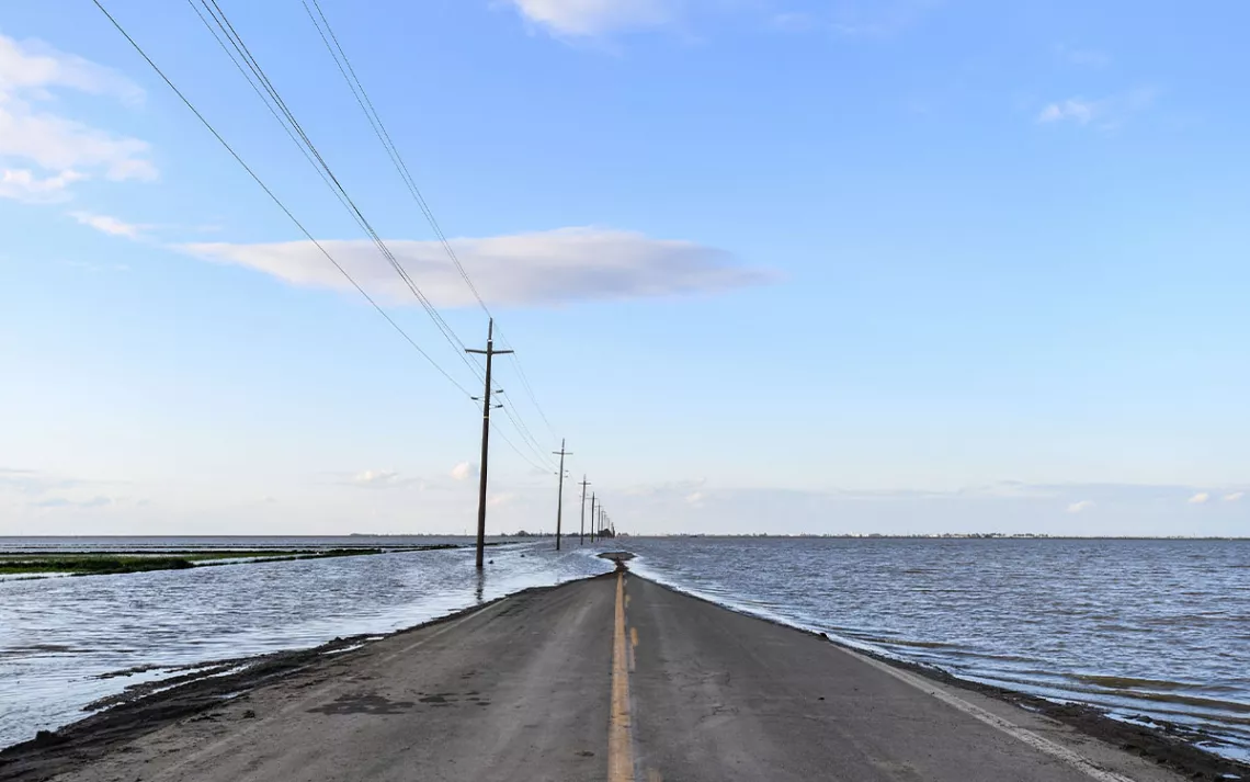
California’s Central Valley on March 23, 2023. Before Tulare Lake was drained in the late 19th and early 20th centuries for agriculture, it held the largest body of freshwater west of the Mississippi River. | Photo by Ken James/California Department of Water Resources
*
The summer I visit the Sacramento Valley is the first summer after the devastating storm in Abbotsford. Despite the city rebuilding a destroyed section of dike, water from the Sumas River still seeps through the reinforcements into a cattle farm. The flooded area has shrunk to the size of a few soccer fields, but its water still teems with ducks and geese. To the Semá:th people, it still carries the spirit of Sumas Lake.
Historically, Sumas Lake would have been this small only during a major drought. But even without the natural lake as an indicator, signs of dry times are cracking through the landscape. In 2022, the town of Chilliwack, just up the Fraser River from Abbotsford, has recorded the hottest August and September in more than 140 years. And while Abbotsford—which relies on some groundwater for drinking—has several stable aquifers, the region is also home to the only two aquifers known to be declining near the southern coast of British Columbia. (Aquifers are also crucial for replenishing local streams and rivers from below ground during summer.) And while drought may be more subtle here than it is in California, scientists project that parts of the province are due for hotter and longer dry spells between downpours too.
The fact that his home feels distinctly “droughty” so soon after the costliest flood in BC history concerns Murray Ned. “For me and my generation, we may not have to endure it too much,” he says. “But for my grandchildren, my kids.... Yeah, it’s very alarming.”
As executive director of the Lower Fraser Fisheries Alliance and an adviser to Semá:th First Nation, where he served as a councilor for 25 years, Ned is especially concerned about culturally important sturgeon and salmon. They’ve been cut off from around 85 percent of their floodplain habitat, which historically included Sumas Lake. Coho, chum, and Chinook salmon still migrate to the area to spawn, along with sturgeon, but all these species are in decline. Warming water and drought are adding new pressures. According to scientists and Semá:th leaders, reviving Sumas Lake could help.
The City of Abbotsford has a different vision, aimed at protecting property and agriculture, and keeping the water at bay. A few months before the heat waves, the city released a flood mitigation plan focused on new dikes and pump stations as well as on raising a section of highway. Like so many planning processes in Canada and around the world, this one didn’t initially have Indigenous leaders at the table. Semá:th chief Lemxyaltexw Dalton Silver sees that as a missed opportunity. Stó:lō leaders, after all, have access to deep generational knowledge of local watersheds, which once defined their clans and dialects.
“The knowledge that our people had has never been respected. The knowledge that some of our people still carry is not respected,” Silver says. “I would really like to see us included in the planning.”
The heart of the matter is reconciliation for past injustices. The Canadian government never consulted or compensated the Semá:th people for the original destruction of the lake that was their cultural and economic lifeblood. Ned’s great-grandfather, Chief Selesmlton, was the leader of Semá:th First Nation in the early 1920s when the government was planning the lake’s removal. Selesmlton—whose traditional name, Kwilosintun, was passed down to Ned—told a royal commission that draining the lake would starve and impoverish his people. In 1923, the colonists did it anyway. When the water finally subsided the following year, sturgeon were found fighting for their lives, poking their pointy heads from the mud. The Stó:lō call this defiant-looking act kw’ekw’e’liqw—“sticking up.”
Despite Semá:th First Nation pursuing claims and compensation for Sumas Lake and the provincial and federal governments both committing to reconciliation with First Nations, flood management remains the responsibility of municipalities. The City of Abbotsford came up with plans and shared them with Semá:th leaders later.
According to city officials, they incorporated some of the nation’s feedback into their proposal, which includes setting back the Sumas River dike to create an overflow channel for water to feed into the lake bottom during big floods. Decisions to revive Sumas Lake more permanently would need to be hashed out with senior levels of government as well as with neighboring First Nations and communities during ongoing negotiations, says Melissa Godbout, a communications officer with the city. Then, actually restoring the lake would require some level of managed retreat: the strategic movement of people and infrastructure out of harm’s way by buying out flood-impacted properties.
Ned and Silver are not naive to the challenges of managed retreat. Silver stresses the need to gain buy-in from the wider community and not inflict displacement on others like the colonial government inflicted on his people when the lake was drained. “I also weigh the human factor,” Silver says. Yet, given the lake’s importance to Stó:lō culture and biodiversity as well as flood protection and water security, the option needs to be on the table, Silver says. “We’ve got to realize our connection to everything around us.”
A few months before the flood, Ned had a dream that felt like reality. He stood ankle-deep in water with his wife, near a beachy bank of the Fraser River. It was a sunny day, and two men fished nearby. But soon, his wife, the fishermen, and the beach all disappeared. Ned found himself waist-deep in rising water. Downriver, a six-meter-long sturgeon—the massive size his great-grandfather would have known—swam straight for him, its spiked tail slicing through the river.
Stó:lō oral history says that the sturgeon was once a girl who spent all her time in the water. The girl’s father, a community leader, gathered his people and decided his daughter should remain in the water forever. He transformed her into a sturgeon who wouldn’t die after spawning. She would survive and keep living to help the people of the future.
The sturgeon in the dream didn’t slam into Ned; it just slithered softly by. Ned ran his hand across its prehistoric body. The next thing he knew, Ned was many meters from shore, surrounded by deep water. What he thought was a river was actually Semá:th Xó:tsa—the lake of his ancestors.
*
As calendars change to 2023, the pendulum swings in California yet again, this time from severe drought to flood. Between late December and mid-January, nine back-to-back atmospheric rivers dump 121 billion cubic meters of water across the state. That’s enough to fill 48 million Olympic swimming pools or flood 120 Sumas Lakes.
The storms are a wicked brew of torrential rain and roaring winds that swallow streets, uproot redwoods, knock out power for more than 2 million households, unleash 700 landslides, and kill at least 20 people. Cities like San Francisco receive almost their annual rainfall in just three weeks. Most of it pours down pavement into the Pacific.
These atmospheric rivers also penetrate hundreds of kilometers inland. In Tulare County—one of California’s most drought-plagued regions, where farmers have pumped aquifers so hollow that even some levees are sinking—the rains at first feel like a gift.
“Water is a new emotion in our area,” Aaron Fukuda, general manager of the Tulare Irrigation District, tells me later. People and nature are happy. The birds come back. The frogs are croaking. “It’s really miraculous what water does bring. When it’s not there, you’re suffering.”
After the first few storms, when the San Joaquin River starts surging, Fukuda and his colleagues open the floodgates to 11 different recharge basins, welcoming water to pool across more than 730 soccer fields’ worth of land. Local farmers call to ask if they can send water onto their properties too. “On the first day, I think we had 70 or 80 orders,” Fukuda recalls. Through this collective effort, the county secures enough groundwater in January alone to run about 18,000 homes for a year.
But by spring, the emotion has changed; the community is experiencing weather whiplash. So many storms have bashed the state that Governor Newsom passes an executive order allowing people to temporarily divert floodwater onto just about any land that will take it. As the drama unfolds, Tulare County also witnesses a surprise transformation: an ancient lakebed—which historically held the largest body of freshwater west of the Mississippi—is rapidly refilling. The lake once supported the Yokut and other Indigenous tribes, and long before them, wooly mammoths and other now-extinct megafauna. At the end of May, it ripples across 470 square kilometers—nearly the size of Lake Tahoe to the north.
Many fear that Tulare Lake will swell more with the “big melt.” All those atmospheric rivers have stacked enough snowpack on the Sierra Nevada to fill the lakebed four times over. “It’s like your bathtub’s full, your rugs are saturated, and somebody turns the nozzle back on,” Fukuda says.
In this case, the bathtub contains staple crops like tomatoes, cotton, and safflower as well as industrial infrastructure from chemical plants to rail lines. Farmers get to work building berms in a last-ditch effort to save crops and cows, many of which have already been lost.
How much more they and others lose depends on what communities do next. When water rises and reclaims some of its land, will people keep fighting with dirt, dikes, and pumps? Or will more of us pull back and make room for water to transform?
Similar questions are emerging along the former shores of Sumas Lake. “There’s going to be a lake returned at some point, no matter how big you build the infrastructure,” says Ned. “That’s Mother Nature, that’s climate change. It’s pretty hard to control.”
Like the Tulare Lake basin, the dry bed of Sumas Lake is the product of more than a century of colonization. The area has been divvied up into 1,375 properties—many of them potato and dairy farms. It’s also bisected by power lines, a national highway, and the controversial Trans Mountain oil pipeline.
Yet, restoring the lake may still be cheaper than the status quo. In a forthcoming study that Semá:th First Nation worked on in partnership with the University of British Columbia, buying out all the lakebed properties at current land values would cost around CAN$2 billion, compared with Abbotsford’s $3-billion-plus plan to reinforce flood barriers. These savings line up with other Canadian examples of managed retreat. In Grand Forks, British Columbia—which was devastated by flooding in 2018—the community agreed to remove or relocate 70 buildings after learning that long-term flooding could triple the cost of retreat.
Whatcom County, Washington, is working on a similar program for the most threatening bends of the Nooksack River—that wild and shifting waterway that defied the US border in November 2021 when it reverted back to its ancient northward course and barreled, downhill, into Sumas Lake. There, the county is in the process of acquiring nearly US$23 million in state and federal grants to buy out 23 properties and elevate 29 structures, several in the town of Everson, where the Nooksack roared through Main Street.
The Whatcom County plan is an example of partial retreat that prioritizes the most at-risk homes and businesses in the floodplain. “We’re not looking at buying out the whole impacted area,” says Paula Harris, the county’s river and flood manager. “That’s whole towns. They’re all we’ve got.” Still, it’s an acknowledgment of the power of water, which will rise again and flow downhill. “We’re fighting gravity.”
*
Fourteen months after the Abbotsford flood, workers suck up the last remnants of Sumas Lake, almost exactly 100 years after settlers began efforts to tame it. As eagles and herons look on, representatives from the City of Abbotsford, Semá:th First Nation, and the Lower Fraser Fisheries Alliance drag a 60-meter seine across the water. They search for any fish that may have gotten trapped on the wrong side of a barrier humans built.
Four people on foot plus two in a small boat struggle through the cold water to close the net. When they finally pull it to the surface, one wild coho salmon stands out in blazing spawning colors, months after it should have released its sperm and died. And amid a sea of invasive carp, three large sturgeon wriggle their iridescent bodies. They twitch. They fight. They stick their heads up, defiantly, from the receding water.
 The Magazine of The Sierra Club

