What Makes a Firenado?
There’s a lot to learn about the fiery twisters

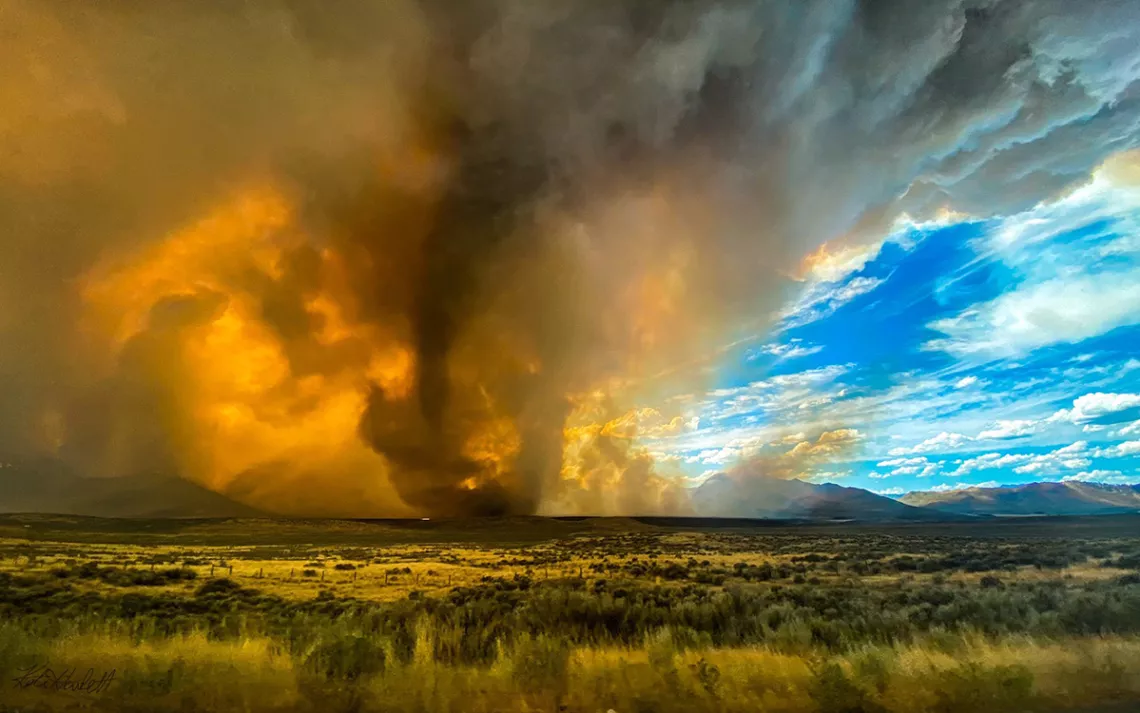
Pyrocumulus clouds over the Loyalton Fire | Photograph courtesy of KateLynn and Jordan Hewlett
On August 15, meteorologist Wendell Hohmann was driving to his afternoon shift at the National Weather Service (NWS) Reno office when something ominous in the sky caught his attention: a towering, tilted pyrocumulus. It looked like the kind of cloud that is known, colloquially, as a fire cloud, because they form over flames.
In extremely rare cases, a pyrocumulous can intensify the speed of the “fire whirls” that often form at the edges of wildfires. This worried Hohmann, who saw that the cloud’s angle signaled some serious rotation. Otherwise, he said, the morning weather was unimpressive, with quick but weak thunderstorms.
Hohmann arrived at the office, sanitized his workspace, and immediately spotted what looked like tornadoes on the radar—five of them. Tornadoes rarely appear west of Utah, but the location offered a clue: They had popped up in the same area as a then-20,000-acre wildfire originating in Loyalton, California—near where he saw the pyrocumulus.
Regular tornadoes are formed by thunderstorms. These were likely spawned by the raging blaze. That spelled more danger for firefighting crews—twisters can spew burning embers, suddenly change direction, and spread fire in ways that make it hard for experts to track where the flames are headed. The Reno office had just begun organizing a Loyalton fire response team, Hohmann said. “We needed to heighten the awareness of the situation.”
So NWS Reno issued the first-ever fire tornado warning in US history. “There was not one particular detail we could take out that said, ‘Hey, we’re going to get fire tornadoes that day,’” said Marvin Boyd, another meteorologist at NWS Reno. After sending out the warning, NWS Reno began to see videos that people near the wildfire had posted online, which made them even more sure, said Boyd. “There’s no question, it definitely looked like a tornado.”
That announcement launched the Loyalton twister into the big leagues. NWS Reno estimated the tornado at between EF-1 and EF-2 on the five-category Enhanced Fujita Scale, which means that its wind speed could have reached as much as 135 miles per hour. During the Carr Fire in 2018, intersecting westerly and northerly winds produced a firenado with gusts above 143 miles per hour. That tornado was classified as an EF-3, the strongest ever recorded in California. In 2003, a twister ranging between EF-2 or EF-3 launched a fire tanker and police car into the air and became the first recorded fire tornado in Australian history.
Not everyone agrees with the addition of “fire tornado” to the weather lexicon. Janice Coen, a project scientist at the National Center for Atmospheric Research in Boulder, Colorado, does not use the term “fire tornado” and especially not “firenado.” Neither are scientifically precise, she said—just slang for more intense forms of “fire whirls.” The biggest twisters, said Coen, are created by powerful fires, wind storms, hot, dry conditions, and a temperature contrast between the fire and the surrounding air, but they aren’t significantly different—just bigger.
Coen also disagrees with the notion that twisters this size are a new phenomenon. Fire whirls as large as the ones that were seen in California last week have likely occurred throughout history, Coen said, because extreme fires are nothing new. The Great Fire of 1910 that tore through the western United States could have had them. The World War II bombings of Dresden, Hamburg, and Hiroshima bred fire whirls, after all. What is new is the ability to detect and classify between the tiniest and most gargantuan whirls.
Others think there is space for a “fire tornado” to be labeled as a distinct structure. Michael Gollner, an assistant professor of mechanical engineering at the University of California, Berkeley, studies how wildfires spread through a landscape. A fire whirl ranges from 11 inches to 500 feet in diameter and is amplified primarily by heat and wind from the flames below. Those in the contentious fire tornado classification can grow more than 2,000 feet wide, to the point where it is also being strengthened by the clouds overhead. A twister that size requires very specific circumstances to form, said Gollner. “There’s always something very unique about the conditions that cause this. Otherwise we’d see this much more often.”
Since its invention in 1954, meteorological radar has allowed researchers to track unusual phenomena more closely. Early radar made it difficult to discern between fire whirls and tornadoes, said Gollner, and even now, the meteorologists in Reno haven’t gotten confirmation yet that what they spotted on the radar last week was as powerful as it looked. Once the fire dies down, investigators will go in and survey the damage where the funnel touched down, and look for signs like overturned cars for clues to the actual velocity. That step will come soon, Hohmann said, because the fire is now 90 percent contained after blazing around 47,000 acres.
Both Gollner and Coen are hoping to learn from this experience, whatever the name it goes by. It’s challenging to issue warnings for twisters this large because scientists still don’t understand what propels them to this size and what role factors like crosswinds and landscape play. The more research, the greater the likelihood that meteorologists will be able to predict them the way that they can with tornadoes, and not just spot them once they’ve already formed. It’ll also be crucial to develop future disaster response, Hohmann said. This unique situation makes evacuation even more complicated than usual—how can people stay in their basements during a wildfire?
Because of new computational models and data from recent disasters like the Carr Fire, researchers are learning more about where and how to look for tornado-like structures on radar. Hohmann had the Carr Fire on his mind when he made the call, he said. The data and video collected of the Loyalton Fire can help scientists further examine this meteorological mystery. “There was a good sample of data from the radar,” said Boyd. “This case will probably be looked at quite closely."
 The Magazine of The Sierra Club


