The Big Thaw
Alaska becomes the nation's first frontier of climate disruption
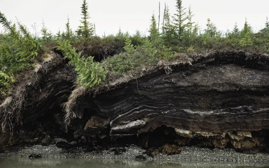
Permafrost melting in Alaksa

This story was produced in partnership with Type Investigations, where Adam Federman is a reporting fellow. Federman is the author of Fasting and Feasting: The Life of Visionary Food Writer Patience Gray.
ON AUGUST 24, the National Park Service closed more than half of the only road that runs through Denali National Park, one of Alaska's top tourist destinations. The proximate cause was a landslide beneath a particularly harrowing stretch of the 92-mile, mostly gravel road that forced it to buckle and slump. The ultimate cause, the Park Service determined, was global climate change. The landslide under the road had been moving slowly for decades without incident; its increased speed was triggered by a combination of heavy rainfall earlier in the season and thawing permafrost. Suddenly, what for years had been a routine maintenance operation had become a Sisyphean task: The Park Service was hauling in 100 truckloads of gravel every week from the nearby Toklat River just to keep the road level and the tour buses moving.

A slow-moving disaster: Some densely populated sections of Fairbanks are vulnerable to permafrost thaw. Here, an apartment building slumps on its foundation.
Eventually, even those extreme efforts proved inadequate. According to the Park Service, the landslide was moving too fast for maintenance crews to safely keep the road open beyond the affected section. The added gravel meant there was less room for buses to maneuver around an especially tight corner just before the vulnerable section of road, which has a 400-foot drop on one side. The road was beginning to cleave and settle at a rate that had never been seen before. Nancy Russell, who has been a bus driver in Denali for over 25 years, said drivers on the morning shift never knew what they might encounter. "They [the Park Service] always said it's not going to be catastrophic," Russell told me. "But I think that's why they had to call it. Because they couldn't say that anymore."
The Pretty Rocks Landslide, named after the striking hues of the surrounding escarpment, is among the most closely studied geological formations of its kind. During the construction of the road in the 1920s and early '30s, engineers commented on the difficulty of building on permafrost and having to "allow the subsoil to thaw and drain" in order to create a more stable surface. As the climate warmed in recent decades, the ice holding the mass of rocks together began to vanish, leading to occasional road closures. By 2018, the road was settling a few inches every week, which was easy enough to correct with periodic filling and grading. But no one was fully prepared for the shift that occurred last summer. By the time the road was closed for good—park staff had to spend about a week evacuating guests and employees in lodges on the other side of the landslide—the slurry of rock and ice was moving at a rate of more than 15 inches a day. A month later, the road had dropped by 21 feet, and large cracks, in some places three feet wide, opened along the surface.
Most of Alaska sits atop permafrost, a layer of soil and ice that has remained stable for hundreds of thousands of years across much of the Arctic. As the climate continues to heat up, the ground is thawing, leading to unexpected and sometimes catastrophic outcomes. Interior Alaska, which includes Denali and covers nearly 450,000 square miles, is located on "discontinuous permafrost," meaning the ground is not uniformly frozen, which makes it riskier to build on. In addition, subsurface temperatures in that part of the state are just below the 32ºF threshold, which means that even modest warming can trigger rapid changes. "In a lot of ways, Denali really is the canary in the coal mine," Denny Capps, a Park Service geologist, told me.
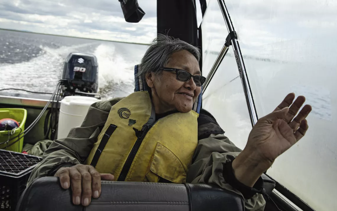
Diana Ramoth says "no one's addressing" the consequences of permafrost thaw.
Alaska as a whole is a bellwether for the rest of the country. It is warming significantly faster than anywhere else in the United States. Since 1950, Alaska's average temperature has increased by more than 5ºF, according to the National Oceanic and Atmospheric Administration. The cost of maintaining roads, bridges, airports, and railways in the region is expected to balloon over the next several decades. Meanwhile, one recent study showed that more than 3 million people across the Arctic live in areas where permafrost is expected to become highly unstable or disappear by 2050. This will likely force entire communities to relocate.
In spring, NOAA released data that showed average temperatures at a weather station in Fairbanks, Alaska's third-largest city, had surpassed 50°F for four months of the year. Rick Thoman, a climate specialist at the University of Alaska Fairbanks, pointed out that the city could therefore be classified as having a "warm summer continental" climate rather than a "subarctic" one. The city's residents, long accustomed to the vagaries of living on permafrost—many homes are built on adjustable foundations and have aboveground septic systems—will have to prepare for more disruptive temperature and landscape changes. Densely populated neighborhoods and numerous subdivisions in areas of ice-rich permafrost are vulnerable to rapid thaw, according to a team of scientists at the University of Alaska Fairbanks who are developing a permafrost hazard map for the city. As with other climate-driven disasters, the consequences of the thaw will be uneven, disproportionately affecting those without the resources to move.
The slow-moving nature of permafrost thaw presents another set of challenges for residents of villages in rural Alaska, many of which are also affected by coastal erosion and flooding. The phenomenon is not treated like other natural disasters such as earthquakes or hurricanes, which are often deadly and produce dramatic and attentiongrabbing images. Entire communities are built on permafrost, yet their residents have no equivalent to fire or flood insurance. It is also difficult for municipalities to tap into federal funding for damages related to permafrost thaw, because it isn't considered an immediate threat to life or property. Mitigation grants are often tied to formal disaster declarations or the cost-effectiveness of a proposed project, which in Alaska, with its low population density and remote settlements, is a high bar. A 2009 Government Accountability Office (GAO) report on climate impacts in Alaska Native villages noted that resources are typically made available once a disaster has struck, but there are few programs to help prevent one. Taken together, this has blinded policymakers to the challenges ahead.
Last January, the operator of the Trans-Alaska Pipeline System, which extends 800 miles from Prudhoe Bay to the Port of Valdez, was granted approval by the Alaska Department of Natural Resources to install dozens of new thermal cooling mechanisms to keep the ground frozen and prevent structural damage or potential spills. "The pipeline was designed to handle the dynamic nature of permafrost, but not in a rapid climate change environment," the executive director of the Pipeline Safety Trust told E&E News. A study published in the journal The Cryosphere in May found that sections of the Dalton Highway, which parallels the pipeline, could experience much more rapid degradation than previously thought. "Existing infrastructure was not planned or designed or built in a way to withstand these changes," Vladimir Romanovsky, a leading permafrost researcher at the University of Alaska Fairbanks and one of the authors of the study, told me.

Grant Ballot recalls when the Selawik River was narrow enough to skip a coin across.
On a clear morning in mid-June, I met Ronald Daanen, a geohydrologist with the state's Department of Natural Resources, at a small, tree-lined lake in Fairbanks. We were about 10 miles north of downtown in the Goldstream Valley, an area that Daanen and others have been studying, in part, to determine the amount of methane gas being released as the ground thaws. Daanen was testing out a newly purchased "autonomous surface vehicle"—it looked like a small Jet Ski—that will allow him to measure the rate of temperature change in soils underneath thermokarst lakes, which have formed as a result of thawing permafrost. Over time, as the ground continues to warm, the lakes will expand. Nearby, a couple of spruce trees were partly submerged and bent over, their roots rotting in the water. A small home on the opposite shore had been abandoned. The lake itself seemed to be eating away at the landscape.
"How many years does it take for that to be affected," Daanen wondered, looking toward the road. "I would say this is going maybe at a meter per year. In another 10 years, that power pole might be affected. All these things add up."
They do add up, but perhaps not fast enough to spur the kind of action required to prepare for future calamities. This is what Daanen calls a "slow disaster," one that to the human eye seems to be unfolding along a normal timescale but in geological terms is moving alarmingly fast. The Pretty Rocks Landslide proves how even slow-moving disasters can suddenly accelerate. For decades, minor tweaks and regular maintenance were enough to ensure safe passage. But as Daanen noted, "nobody could have predicted the rate at which these soils are warming up."
ALASKA'S VULNERABILITY to climate change has been well understood for decades. In 1990, Democratic governor Steve Cowper's office drafted a report on the scale of the problem and appropriate policy responses, including diversifying the state's energy portfolio and preparing for the effects of permafrost thaw on rural communities and oil and gas infrastructure. But it went nowhere. Sporadic efforts to establish a permanent subcabinet devoted to climate change and to pass related legislation at the state level have also been met with resistance. In 2019, Governor Mike Dunleavy, a Republican, dissolved a climate change task force that had been established under his predecessor. That same year, a senate bill to establish the Alaska Climate Change Emergency Response Commission died in committee.
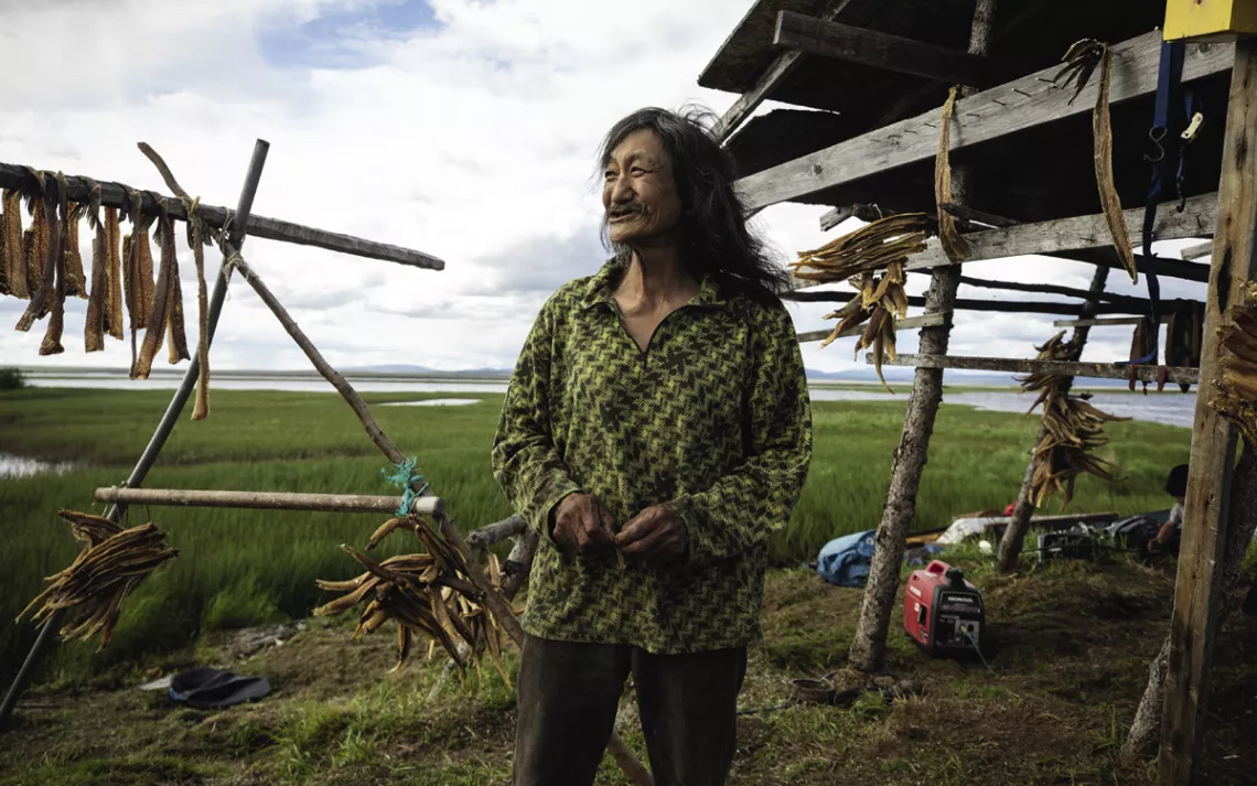
Ingram Clark at his family's fish camp on the river; he says that the shoreline is eroding by about two feet per year.
The state's faltering approach is in part a result of its decades-long dependence on oil and gas revenue and cozy relationship with the industry. Alaska has no sales or income tax and has had to start relying on its "permanent fund," a product of the oil boom of the 1970s, to partially fund the state budget. (Alaska residents also get an annual dividend from the fund.) Jeff Stepp, who served as a special assistant to the Fairbanks mayor from 2015 to 2019 and worked for the legislature's budget and audit committee until last January, said that the state has failed to reckon with the long-term fiscal implications of a changing climate. "The rest of the world recognizes we're at ground zero," he said, "but as a state, there's very little interest in addressing climate change."
Federal programs have not fared much better, and the federal response to climate impacts in the Arctic has not met the scale and pace of change. In 1998, Congress created the Denali Commission, an independent agency based in Anchorage that works on infrastructure-related development projects in rural communities. When the Obama administration announced a major Arctic policy initiative in 2015, the commission was given the lead role on climate adaptation, including village relocation programs. "We're now on offense, and we're ready to play," the commission's co-chair told The Washington Post at the time. But a year and a half later, the Trump administration tried to defund the agency (Congress voted to fund it anyway). Trump also disbanded the newly created Arctic Executive Steering Committee, designed to coordinate Arctic policy across federal agencies, and left the US special representative for the Arctic position, created under the Obama administration, vacant for most of his presidency.
Now is the time for environmental journalism.
Sign up for your Sierra magazine subscription.

"The federal government is nowhere near equipped to address the issues we're describing in Alaska," Robert Verchick, an environmental law professor at Loyola University New Orleans and a member of Obama's Interagency Climate Change Adaptation Task Force, told me. Verchick said that there are two fundamental problems: insufficient funding and the absence of a single agency to address the complex issues facing communities on the front lines of climate change. The federal government is accustomed to engaging with communities after they've been hit by a hurricane or flood, but it's less adept at addressing slow-moving disasters such as permafrost thaw. This often means villages, tribes, and municipalities in rural Alaska are left to fend for themselves. (One exception is drought, which does qualify for emergency funding.)

Whitefish and pike hang to dry at the fish camp.
Governor Dunleavy's office did not respond to requests for comment. Mike Sfraga, the newly appointed chair of the US Arctic Research Commission, which advises the White House and Congress on policy in the region, said that the costs and uncertainty associated with building on thawing permafrost, as well as maintaining existing infrastructure, present a major challenge for Alaska. "We can either continue to consider what is happening and what we should do about it or we should do what we have been considering for the longest time," Sfraga said. "And that is planning for what is the inevitable."
Selawik, a town of about 800 people in northwestern Alaska that is just over 70 miles from the coast, is emblematic of the challenge. Situated on land that has been inhabited by Iñupiat for thousands of years, today's permanent settlement was established in the mid-to-late 1800s along a stretch of the Selawik River known for its abundant fishery. The town is located within the Selawik National Wildlife Refuge, which is home to thousands of lakes and 180 documented bird species, including Pacific loons and Arctic terns. It is a freshwater ecosystem that is defined by its proximity to the Arctic Ocean: Spotted seals and beluga whales have been known to make their way from Kotzebue Sound, an arm of the Chukchi Sea, upriver in pursuit of fish.
The summer afternoon I arrived in Selawik, the tribal council was holding a special meeting to discuss the use of federal pandemic relief funds. A list of priorities had been written on a whiteboard. Nearly every item was related to the built environment: water and sewer repairs, rebuilding the community center, closing the old landfill. In addition to keeping the village safe during the pandemic, Selawik leaders were in the middle of building a new tribal store—the old one had been destroyed in a fire—and grappling with a four-month-long boil-water notice after a power outage in February had taken the water-treatment system offline. The loss of power, which had lasted for three days during subzero temperatures, had also damaged the municipal septic system. Much of the town was still relying on "honey buckets" to dispose of waste. "It's got a bunch of Band-Aids on it," Selawik tribal administrator Tanya Ballot told me, referring to the town's water-treatment system. "And the Band-Aids have sprung leaks."

Kids play on a lookout tower at the camp.
Selawik's size—it is the second-largest community in the Northwest Arctic Borough—distinguishes it from other villages that are grappling with climate impacts. Its location near sea level and on permafrost has given rise to an extraordinarily complex and fragile built environment. Selawik's water and sewer lines are all aboveground and housed in a thick layer of insulation to prevent freezing during winter. Elevated wooden boardwalks, just wide enough for a couple of four-wheelers to squeeze past each other, serve as roads. Two bridges connect the town's three "neighborhoods": school side, island side, and airport side. Life still revolves around the river. It provides the town's drinking water and is one of the only ways to bring in heavy machinery and other critical supplies. On late-summer evenings, kids jump from the "rainbow bridge" in the center of town.
In 2012, the nonprofit Alaska Native Tribal Health Consortium published a report on climate change in Selawik. It echoed what elders and other residents had been observing for years: Thawing permafrost and erosion were making life there increasingly tenuous. The report identified at least three dozen homes along the river that are threatened by erosion. The network of water and sewer lines is particularly susceptible to damage from ground thaw, which has contributed to residents paying some of the highest utility rates of any community in Alaska. Even the town dump and the sewage lagoon, which borders the main stem of the Selawik River, are at risk of being breached because of the shifting terrain.
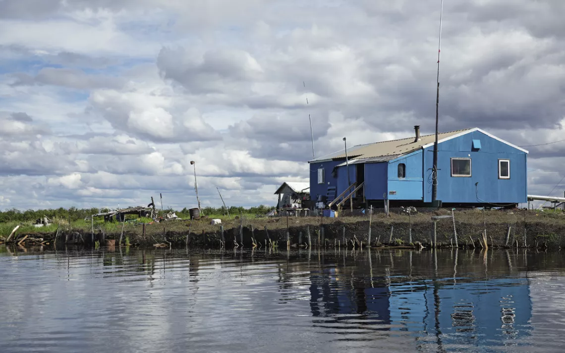
Home near a continually eroding section of the Selawik River.
During the council meeting, Diana Ramoth, who is 64 and grew up in Selawik, noted that 168 homes were on foundations that needed to be made level because of thawing permafrost. The council suggested that COVID-19 relief funds be used to shore up those residences. Ramoth, who has worked on drafting climate change resolutions for the village, said that pushing for more ambitious policy changes has stalled at the local level. Several years ago, she said, village leaders were considering relocating to higher ground north of town, where there is very little permafrost. "But nothing came of it," she said. "No one's addressing it."
Nearly a decade has passed since the tribal health consortium's climate change report. In the intervening years, however, there's been no coordinated government effort to assist Selawik. Tuva Volden, a PhD student at Copenhagen University, wrote her master's thesis on the policy response to climate change in the village and interviewed 24 residents over the course of three weeks in spring 2019. She found that little had changed since the health consortium's report had been written. "In a lot of cases, we're seeing extreme natural disasters, which do spark some sort of reaction and attention politically and from the public in general," Volden told me. But in a place like Selawik, she added, where the changes are less spectacular, at least to outsiders, there is less pressure on state and federal agencies to act.
Selawik is not the only Alaska Native village facing the prospect of having to relocate because of climatechange-related permafrost thaw and flooding. The 2009 GAO report identified 30 other villages in the state that were in a similar predicament. A handful have developed plans to move elsewhere, a hugely expensive and logistically difficult undertaking. But only Newtok, a coastal village in southwestern Alaska, has managed to get beyond the planning stages and initiate the relocation of its approximately 350-member community. I asked Diana's brother, Clyde Ramoth, a former mayor and tribal administrator in Selawik, how much longer the village could safely stay where it is. He said without hesitation, "Inside 10 years."
IN 2004, a pilot with the US Fish and Wildlife Service was flying over the Selawik River and noticed that the water was unusually cloudy, the color of chocolate milk. He followed the plume upstream and encountered what appeared to be a massive crater on a bend in the river. The "Selawik Slump" is believed to be one of the largest thaw-related disturbances in North America. Over the past decade and a half, the formation, located about 175 miles upriver from the village, has deposited more than 700,000 cubic meters of soil and debris—roughly 70,000 dump-truck loads—into the water.

In Selawik, water and sewage lines were built aboveground to accommodate permafrost.
Benjamin Crosby, a geologist at Idaho State University who has studied the slump's impact on the health of the ecosystem, said it is still pumping sediment into the river. Though the amount of soil entering the Selawik River has diminished over time, erosion and thawing permafrost have continued to eat away at its banks. In aerial photos of the region, it looks like a bomb was dropped in the middle of the wilderness. The slump stabilized for a couple of years around 2016 but has since been reactivated, perhaps by heavy rainfall and continued warming. According to Crosby, the injection of so much sediment into the water prevents sunlight from reaching the river bottom, which can have a cascading effect up the food chain. Plants do not receive the sunlight they need to grow. Insects that feed on those plants are less abundant. Larger fish species are left to compete for fewer resources. For a few years after the event occurred, the Selawik was so muddy that sheefish swam up another tributary, the Tagagawik, to find suitable habitat in which to lay their eggs; long-term impacts for the species remain unknown. Tanya Ballot said that the high level of turbidity in the river also affected the village's water-treatment system.
As the climate continues to warm, the frequency of thaw-related slumps along river systems in Alaska and the Arctic will increase, Crosby said. At least one smaller disturbance has already been recorded closer to the village, and several have been observed along the nearby Noatak River. Studies of similar ecosystems show that the impacts could transform entire watersheds. A 2013 paper by a group of Canadian researchers working in the Mackenzie River delta found that hundreds of rivers were already being reshaped by mass erosion. The study noted, "Long-term geomorphic impacts can be expected because these large slumps remain active for decades, while new slumps continue to initiate."
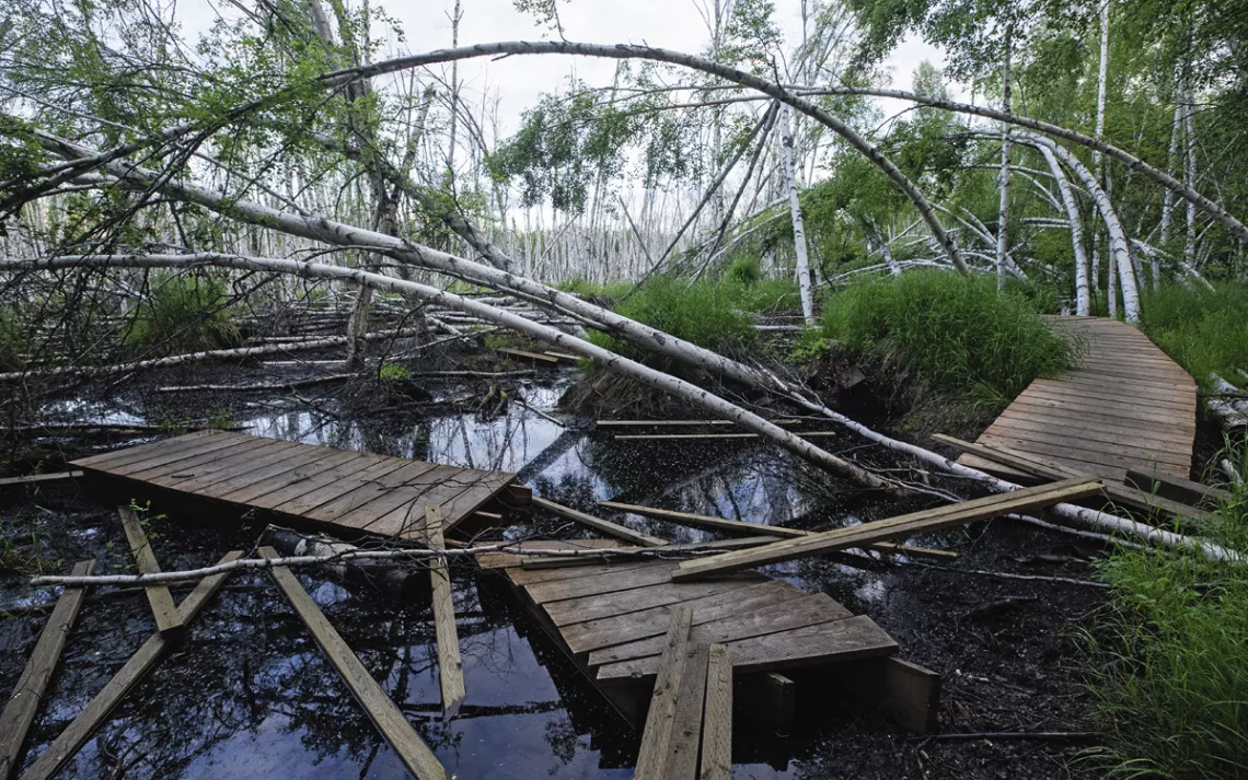
At Creamer's Field, a state-owned park and bird refuge in Fairbanks, the effects of permafrost thaw and rising temperatures resemble the damage wrought by a hurricane.
The effects of erosion and permafrost thaw are visible all along the Selawik. Most of the elders I spoke to recalled being able to toss a coin across the river 50 years ago or swim underwater from one side to the other, which is no longer possible. "There are a lot of places where sod huts used to be," Grant Ballot, who grew up in Selawik and is now 80, told me. "It's all gone. It all eroded away."
One afternoon, Diana Ramoth took me in her boat to look at some of the impacts of climate change along the river and to visit a friend who still spends summers at his family's fish camp. We entered the Selawik just below the rainbow bridge and idled past a brightly painted home a few feet from the edge of the riverbank. Ramoth pointed out another spot nearby where she said a home had already succumbed to erosion. An old bathtub, rusted metal pilings, and an oil drum were scattered along the shoreline.
We left the village and traveled up a narrow slough lined with river grasses and willows. Eventually, we approached a small cluster of wooden huts on a narrow strip of land about seven miles from the village, where Ingram Clark and his family have spent every summer for the past 43 years. Like many in Selawik, Clark has witnessed the impacts of climate change firsthand. The shoreline below his camp has eroded significantly, about two feet every year for the past decade, he said. He had woven together willow branches along the base of the exposed riverbank to stabilize the slope, but the bank was losing ground every year. Still, he said that he had no plans to abandon the site and that he'd continue to return as long as he was able to. I asked him what would happen when there was no more ground left to retreat to. "You can't stop water," Clark said. "Eventually it'll eat it away."
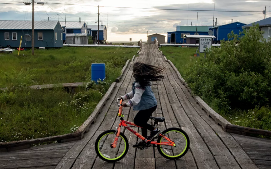
Thawing permafrost and erosion threaten the northwestern Alaska community of Selawik.
Scientists and area residents have observed other ecosystem changes in recent years. Over the past decade, the Western Arctic caribou herd has stopped moving through Selawik and neighboring villages during its fall migration. The ground cover is changing as larger plants and shrubs replace the subalpine vegetation. Even the water chemistry has been altered by warming weather and increased sedimentation. Susan Georgette, manager of the Selawik National Wildlife Refuge, told me, "Sometimes as a land manager here, you feel like you're holding your breath waiting for a collapse in the environmental health of the system."
ON A MID-JUNE MORNING IN FAIRBANKS, I met Terry Chapin, a retired ecologist, at Creamer's Field, a former dairy farm that is now an 1,800-acre, state-owned park and migratory bird refuge in the middle of the city. The refuge also provides one of the most striking examples of climate impacts on the boreal forest region, which covers more than 100 million acres in Alaska. Chapin and I walked along one of the main trails through a stand of birch trees that until recently had been a seasonal wetland, filling only in the spring after snowmelt. But increased precipitation in parts of Fairbanks, largely a result of diminishing sea ice, means the wetland is now permanent.
It looked as if a hurricane had swept through the area. A wooden boardwalk winding its way through a mile-and-a-half section of forest had been ripped apart as the ground had subsided. Dozens of birch trees were bent at 90-degree angles or snapped in half, their submerged roots drowning. It seemed almost implausible that the damage had been caused by thawing permafrost. But this was a glimpse of Alaska's future.
Chapin noted that because the climate is changing so quickly here, we can already see the impact on nature and people. "You can see how the system is responding to change or denying change or resisting change," he said. We continued walking until the trail became impassable. A small sign explained that the boardwalk, built in the 1970s, was not designed to be "continually inundated with water," and as a result some portions had "floated apart and are damaged beyond cost-effective repair."
The acknowledgment captured the position the state now finds itself in: scrambling to prepare for a future that has, in many places, already arrived. It's not too late for state and federal agencies to address the issue of permafrost thaw and climate adaptation in the Arctic more broadly. But as a recent paper put out by the University of Alaska Fairbanks's center for Arctic policy studies noted, the "window for addressing these changes through adaptation is narrowing." Verchick, the environmental law professor at Loyola, said there are some encouraging signs that the Federal Emergency Management Agency is beginning to pay more attention to pre-disaster planning, which could benefit Alaska. In 2018, the agency launched the Building Resilient Infrastructure and Communities program, which will distribute $1 billion in funds to states within the next year. Meanwhile, the Biden administration has restored the Arctic Executive Steering Committee, naming an Alaska Native as its deputy director, and appointed new members to the US Arctic Research Commission.
But the scale of the problem in Alaska will require a far greater investment in the coming decades. According to a recent estimate, the state will need to spend hundreds of millions of dollars a year battling the effects of climate change, including permafrost thaw and coastal erosion, even as oil and gas revenue, the cornerstone of the state's budget, continues to decline. A proposed bridge that would replace the compromised section of Denali Park Road, for example, is expected to cost at least $55 million.
This past fall, the boardwalk at Creamer's Field was repaired, as it has been annually for the past several years, and the boreal forest trail reopened in mid-September. It's only a temporary fix though. The refuge will probably have to do the same repairs next year and the year after. Meanwhile, the nonprofit Friends of Creamer's Field says that it may need to apply for grants to fund a more durable solution. A volunteer at the visitor center said that she encourages those who use the refuge to call the Alaska Department of Fish and Game and tell it how much they value the trail. But for now, the state will do what it has always done: make minor adjustments and hope for the best.
This article appeared in the Winter quarterly edition with the headline "The Big Thaw."
This article was funded by the Sierra Club's Beyond Coal campaign.
Learn how methane emissions from thawing permafrost contribute to increased warming: sc.org/permafrost-emissions.
 The Magazine of The Sierra Club
