SierraScape December 2008 - January 2009
Back to Table of Contents
by Mike Bollinger
Conservation Committee Chair
photos contributed by Bob Gestel
 On Sunday, October 19th nine Sierrans embarked on a beautiful,
but brief fall outing with a purpose. Which is not to say that
outings don't normally have a purpose. Rather, this one had
an additional purpose besides the "normal" goals to
explore and enjoy wild places– two of the three pillars
of the Club's motto. This outing also provided a direct opportunity
to experience the wilderness environs of two special areas,
Lower Rock Creek and
Van East Mountain.
On Sunday, October 19th nine Sierrans embarked on a beautiful,
but brief fall outing with a purpose. Which is not to say that
outings don't normally have a purpose. Rather, this one had
an additional purpose besides the "normal" goals to
explore and enjoy wild places– two of the three pillars
of the Club's motto. This outing also provided a direct opportunity
to experience the wilderness environs of two special areas,
Lower Rock Creek and
Van East Mountain.
The Van East Mountain wilderness area is a tract of just
over 2000 acres of
Mark Twain National Forest
with its peak reaching
1130 feet in elevation. The Lower Rock Creek wilderness area
is much larger, almost 14,000 acres. The property is mostly
Mark Twain National Forest but includes some acreage owned by the
LAD Foundation.
The Creek, a tributary of the
St. Francis River,
is considered by many to be one of the State's "wildest
and most spectacularly scenic areas." I refer to both as
small "w" wilderness areas, in contrast to those 'true'
Wilderness areas designated as such in accordance with the
Federal Wilderness Act of 1964.
 In Missouri, we have seven Wilderness
Areas, all officially designated based on the hard work and dedication
of advocates working in the late 70's and early 80's. In total
they comprise less than five percent of the state's National
Forest lands. Seven additional wilderness areas that were considered
back then, but failed to achieve designation, remain vulnerable.
These include both Van East Mountain and Lower Rock Creek. Now
there is a renewed effort to include them in the
National Wilderness Preservation System.
In Missouri, we have seven Wilderness
Areas, all officially designated based on the hard work and dedication
of advocates working in the late 70's and early 80's. In total
they comprise less than five percent of the state's National
Forest lands. Seven additional wilderness areas that were considered
back then, but failed to achieve designation, remain vulnerable.
These include both Van East Mountain and Lower Rock Creek. Now
there is a renewed effort to include them in the
National Wilderness Preservation System.
Earlier this year, as we discussed the statewide effort to promote the Federal designation of these seven small "w" wilderness areas at an EMG ConsCom meeting, we hatched the idea of visiting two of the candidate sites in our "backyard" for a first hand look at what makes them special. Paul Stupperich took on the planning, scheduling and coordination to turn this concept into reality.
Our mid-October outing, began with a meeting at a commuter
lot in south county to sort out details for carpooling and directions.
We drove about an hour and a half, to access Lower Rock Creek
from its southern side from Highway E just west of Hwy 67, in
Madison County. Paul Stupperich led us on a two mile hike into
the National Forest towards a scenic spot on the bank of Lower
Rock Creek. The leaves were beginning to change and weather
was splendid - both cool temperatures and blue cloudless skies.
We actually had three seasoned
Outings
Leaders on the hike, Paul, Suzanne Smith, and Bob Gestel.
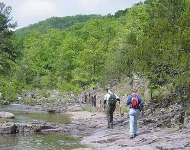 As I mentioned, Paul led the way while Bob took up the
rear, a position outings volunteers refer to as the sweeper.
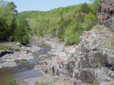
We accessed Lower Rock Creek at a beautiful site, a shut-ins
with a clear flowing stream bubbling and cascading through
rhyolite bedrock bluffs, shelves, and outcroppings. It is truly
difficult to express in words just how impressive this area is.
The beauty of this wild setting in combination with its easy
accessibility (just a short drive from St. Louis and a brief
walk) makes it seem all that much more precious and vulnerable.
The pleasure of a hike in the wilderness with like minded
friends is also difficult to express. A good time was had by
all, even on this short hike, with conversations ranging from
plant identification and prior mountain climbing excursions to
living in South America and the wisdom of flu shots–all
based on first hand experiences of hikers in our small group.
Trails like the one we walked that day are a great example of an
Appalachian Trail
slogan I came across
recently–"a footpath for those who seek fellowship with the wilderness".
But our hike was quickly over, as we wanted to also see portions of Van
East Mountain before heading home.
As I mentioned, Paul led the way while Bob took up the
rear, a position outings volunteers refer to as the sweeper.
We accessed Lower Rock Creek at a beautiful site, a shut-ins
with a clear flowing stream bubbling and cascading through
rhyolite bedrock bluffs, shelves, and outcroppings. It is truly
difficult to express in words just how impressive this area is.
The beauty of this wild setting in combination with its easy
accessibility (just a short drive from St. Louis and a brief
walk) makes it seem all that much more precious and vulnerable.
The pleasure of a hike in the wilderness with like minded
friends is also difficult to express. A good time was had by
all, even on this short hike, with conversations ranging from
plant identification and prior mountain climbing excursions to
living in South America and the wisdom of flu shots–all
based on first hand experiences of hikers in our small group.
Trails like the one we walked that day are a great example of an
Appalachian Trail
slogan I came across
recently–"a footpath for those who seek fellowship with the wilderness".
But our hike was quickly over, as we wanted to also see portions of Van
East Mountain before heading home.
While these two wilderness areas adjoin, it takes a bit of
driving to see them both in the same day by road; if you had
the time, it would be much nicer to travel between them on foot
(as the crow flies). But we drove, west on Hwy E, to Hwy 21
north, to Hwy D east, and on to Hwy FF; a circuitous route, yet
one that allowed us to see Van East Mountain from various vantage points.
 We stopped and looked around for a while at a trail
head, which leads up to the summit, although we didn't have time
to take in a second hike. Those who had hiked it before shared
their perspectives, all explained the views, features and special
characters which make it unique. And a few passing pick-up trucks
with trailers packed with quad-runners, provided an immediate
reminder of one of the largest risks these areas face–without
the protection of Federal Wilderness Designation.
We stopped and looked around for a while at a trail
head, which leads up to the summit, although we didn't have time
to take in a second hike. Those who had hiked it before shared
their perspectives, all explained the views, features and special
characters which make it unique. And a few passing pick-up trucks
with trailers packed with quad-runners, provided an immediate
reminder of one of the largest risks these areas face–without
the protection of Federal Wilderness Designation.
Before wrapping up our visit, we reviewed the reasons these two (as well as the other seven) areas should be listed and what steps each of us could take to help make that happen. We encourage everyone to help–to do your part–the third "Protect The Wild Places of the Earth" pillar of the Sierra Club motto. For specific ideas, please see prior articles on this topic in the Sierran (missouri.sierraclub.org/SierranOnline/2008/01/wilderness.html), pick up a copy of the "Wilderness for Missouri" newspaper at the Club Office, or contact Caroline Pufalt at 314-721-7207 or cpufalt@sbcglobal.net or Michael Bollinger at mfbollinger@gmail.com or 636-938-6594.