The Grand Canyon As It Should Be
What makes the sliver of land and river we call the Grand Canyon so special is what surrounds it.
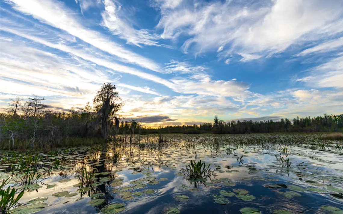
Travis Moles navigates boulders in Kanab Creek, near Grand Canyon National Park. | Photo by Peter Frick-Wright
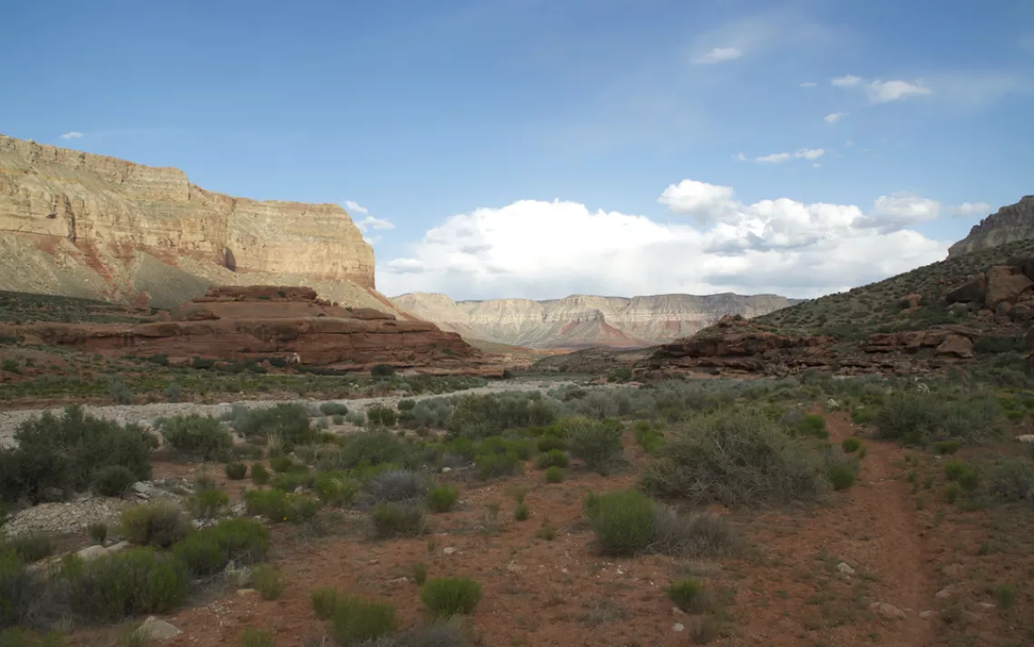
The Grand Canyon region faces a variety of threats, from uranium mines to a proposed new tramway. | Photo by Peter Frick-Wright
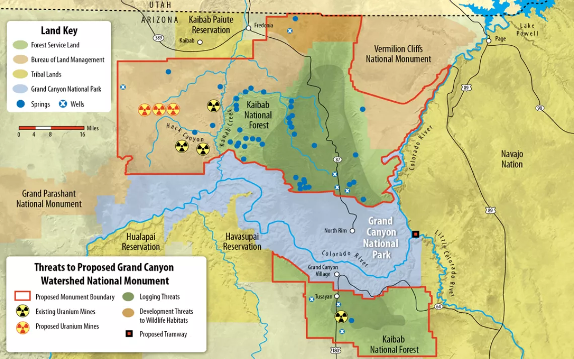
Threats to the proposed Grand Canyon Watershed National Monument. | Illustration by Peter and Maria Hoey
KANAB CREEK STARTS SMALL. At the top, it's just a trickle of water dancing through dust and rock beneath Utah's Paunsaugunt Plateau. But from there, it picks up speed and flows south, headed any which way at any given moment, swirling, bending, arcing hard left and then changing its mind, chewing immeasurably into the ground.
Continue downstream and the rivulet becomes a ravine, which turns into a gorge of breathtaking depth. Ocher spires rise up like geology's own cathedral; oohs and aahs echo off the walls as you hike. Eventually, you'll be standing in the Grand Canyon itself.
But we're not there yet. This is day one. We're 125 miles upriver, a few thousand feet from Kanab Creek's headwaters, and the view is not so sublime. There are no cathedrals of rock, just abandoned cars and No Trespassing signs. In fact, on the other side of a wire fence, there's a barn-size pile of scrap lumber, tires, appliances, and trash that someone bulldozed into the creek.
Ewww.
"I mean, what exactly is their line of thinking?" my friend Travis Moles asks.
"I think the idea is that flash floods wash it all away," I reply.
"To the Grand Canyon?" He sounds incredulous.
"Yeah." I'm incredulous, too.
Kanab Creek is one of the Grand Canyon's largest tributaries. Joining the Colorado River right in the center of Grand Canyon National Park, it forms the western boundary of the Kaibab Plateau—a sky island of fertile habitat rising from the Colorado Plateau on the north side of the park. In 1882, explorer Clarence Dutton called this lush, green landscape covered in old-growth ponderosa pine "the most enchanting region it has ever been our privilege to visit."
But even though Kanab Creek is an artery for a diverse and sprawling ecosystem, only rarely does water actually flow from the top of the creek all the way to the bottom. Follow it south and you can almost watch it being sucked dry by the towns of Kanab, Utah, and Fredonia, Arizona.
That's not even the worst of it. Run down the list of various challenges facing this area and you'll find that groundwater depletion is generally overshadowed by threats of uranium mining, old-growth logging, overgrazing, and too-zealous fire suppression. Those problems also affect water quality and habitat for the whole region and are passed downstream to the Grand Canyon.
And while there are plans in place to address some of these issues, the policies are scattered, piecemeal, and sometimes impermanent. Eleven different forest plans, protection acts, bird treaties, federal orders, and management policies guide the Bureau of Land Management and the U.S. Forest Service in overseeing the Kaibab Plateau. On a map, the different boundaries and designations are so jumbled and overlapped that they become a meaningless conservation word cloud: Grand Kanab Game Forest Wilderness Kaibab National Canyon Creek Preserve Park.
To protect the entire ecosystem, the Sierra Club, as part of the Grand Canyon Watershed Coalition, is proposing an umbrella designation for this whole region: the Grand Canyon Watershed National Monument. Slated to include 1.7 million acres—the entire Kaibab Plateau plus areas threatened by uranium mining to the north and south of the national park—the monument would task the Bureau of Land Management and the Forest Service with prioritizing protection of groundwater and habitat as well as rehabilitation of this long-neglected landscape.
The proposed monument's chief asset—its proximity to the Grand Canyon—is also a liability. The area around the canyon is already threatened by the 1.4-mile Escalade tramway development, which would usher as many as 10,000 people a day to the bottom of the canyon from a point on Navajo land just outside the park. Just south of the national park's South Rim visitor center, developers are forging ahead with plans to construct a shopping mall and more than 2,200 homes (see "Canyon on the Brink," below). Like younger kids lost in the shadow of a more charismatic sibling, Kanab Creek and the Kaibab Plateau have trouble getting attention.
Travis and I have come to the headwaters to follow Kanab Creek from top to bottom, and sure enough, as we were planning this trip, we found that the route was an afterthought for guides, rangers, and other hikers. It was easy to get last-second trip permits and hard to get any solid information, especially about where we'd find drinking water. Various agencies had contradictory advice. Our most trustworthy source—a local who had hiked the creek two weeks before—turned out to be wrong. Our best bet, we decided, was to visually inspect the creek as we followed it south by car. We'd drop in and start hiking when we could see some sort of flow. But we ran out of road before we found water.
So now, as we descend into Hack Canyon—the last easy entry into Kanab Creek—we have three quarts on each of our backs and a half gallon in our bellies but no idea where or when we'll get a refill.
At the moment, we're not all that worried. If Hack Canyon is dry, we've been told, water will probably be running just south of it, in Kanab Canyon.
Hack Canyon is a full zip code wide, with a dry riverbed running down the center and informal paths on either side. It's huge and splendid. At times, we have trouble navigating because the canyon is so much more impressive than what we'd been expecting. Only next to the Grand Canyon would something like this be an afterthought.
Approaching Kanab Canyon, the rock features grow more delicate. We start to see foot-tall redrock mini-arches carved thin and wispy by the wind. The toasted soil turns a martian red; the sky's a Caribbean blue. Yellow cactus flowers interrupt a sage backdrop, and the wind is cool and bracing. It's a recipe for perfection. Just add water.
But the confluence of Hack and Kanab Canyons is also dry. And by the time we arrive, it's getting dark. Travis and I make camp just off the riverbed and go to bed thirsty.

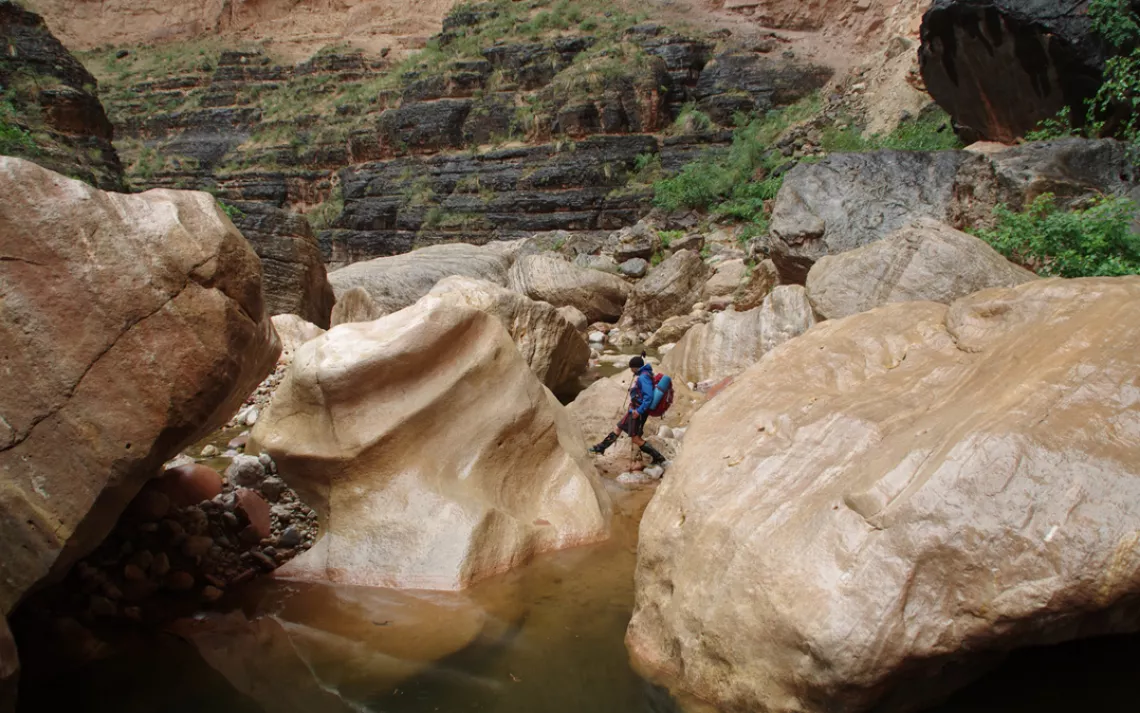
Travis Moles descends into Hack Canyon, part of the proposed Grand Canyon Watershed National Monument. | Photo by Peter Frick-Wright
THE SMORGASBORG OF PROTECTIONS and policies governing Kanab Creek and the Kaibab Plateau are the result of a conservation process that started more than a century ago. But in the beginning, any conservation efforts were laughable.
"The region is, of course, altogether valueless," army lieutenant Joseph Christmas Ives wrote in 1857 while pushing up the Grand Canyon in a stern-wheeler he'd designed and built. "After entering it, there is nothing to do but leave." Other early explorers called the area "a gash in the bosom of nature" and "a prison of cliffs and canyons."
The descriptions changed tune only after Major John Wesley Powell explored the Colorado River in 1869 and 1871-72, published a best-selling journal of his trip, and spent the next couple of decades lecturing about the Grand Canyon as a geologic wonder.
In 1903, Teddy Roosevelt threw his political weight behind the idea of a national park, traveling to the canyon and calling it "the one great sight which every American should see." Five years later, he established Grand Canyon National Monument.
In 1917, Arizona senator Henry Ashurst proposed that it be made a national park, but he tried to appease the miners and cattlemen with land claims in the area. When his bill passed, it only included the canyon and narrow strips of land along the rim, not the streams feeding the park. He preserved the view, not a functioning ecosystem.
For years, environmentalists have tried to get Kanab Creek and the Kaibab Plateau protected, by expansion of the national park or by creation of a national monument. Every time, those locations have come off the table during negotiations with cattle ranchers and mining and logging companies.
"The same interests have opposed it for over 100 years," says Kelly Burke, the executive director of the Grand Canyon Wildlands Council. "It just keeps slipping through the cracks."

Near the headwaters of Kanab Creek, Arizona. | Photo by Peter Frick-Wright
INTERMITTENT HAIL WAKES US the next morning, like a hungry cat bothering you for food and then pretending it's not. I pull my bivy sack up higher and eventually peek out. Travis is awake, and it takes just a few seconds for us to reach a consensus that sleeping is done. We're thirsty. Let's move.
With the flow from the headwaters stopped up at Fredonia, any water we might find will have streamed down from the Kaibab Plateau.
The ecological value of the plateau is hard to overstate. In the early part of the 20th century, it was home to a deer herd that first showed scientists—including author Aldo Leopold—the importance of population balance. And last year, a wolf tagged with a radio collar near Cody, Wyoming, turned up here after traveling some 750 miles. Dubbed Echo in a nationwide naming contest, she was shot in February 2015 by a Utah hunter who mistook her for a coyote. But Echo's dispersal proved the viability of a wildlife corridor stretching from the Grand Canyon to Yellowstone National Park. That swath of wildland is also a critical migratory route for mule deer and an important habitat for California condors and the threatened Mexican spotted owl. It's also goshawk nesting grounds and the only place in the world where you'll find the Kaibab squirrel, which evolved to live in symbiosis with the Kaibab's ponderosa forests when the plateau became surrounded by desert.
But more than all that, the plateau is where clouds dump their moisture in big heaps all winter. That snow then melts into Kanab Creek, which feeds the Colorado River and hydrates California.
Unfortunately, as temperatures increase and weather becomes more erratic, that precipitation comes more frequently as rain, or the snow melts all at once and the landscape can't hold on to it, or it may not come at all. Old-growth forests help regulate things by cooling the whole region, preserving snowpack, and combating wildfires. A national monument designation would keep that old growth intact and require the Forest Service to prioritize habitat in its land-use decisions. But right now, there aren't any formal forest protections in place, so the Forest Service keeps selling trees to timber companies and the snowline keeps moving higher.
We walk on, and the canyon starts closing in. It's the width of a Los Angeles freeway now, and the walls look increasingly warped and Dr. Seussian. Cacti and dry grasses give way to sinewy, smooth reeds growing from the riverbed. Then, finally, there it is. Water.
It's not much—maybe an inch deep—but there are tadpoles swimming dumbly in circles and a whole new swath of biology along the riverbank.

Travis Moles stops to appreciate the height of Kanab Canyon. | Photo by Peter Frick-Wright
IT WAS A PROSPECTOR on John Wesley Powell's initial Grand Canyon expedition who first found a nugget of gold in Kanab Creek. Perhaps even more than Powell's geology lectures, it kicked off a rush to the area.
The problem was, there wasn't much more than the one nugget. So miners dug for silver, copper, gold, and asbestos instead. In the 1930s, they even tapped the bat guano deposit in a cave to sell as fertilizer.
For the most part, however, the mines never paid off. By the end of the 19th century, prospectors were discovering that their trails and land had more value as tourist facilities.
The one big exception was uranium mines. In 1951, a defunct copper mine in the Grand Canyon called the Orphan Mine set off a USGS Geiger counter, and since the claim dated back to 1893, it was grandfathered past even the earliest environmental protections. The deposit was positioned in such a way that as the miners dug and followed the uranium, much of it was outside the claim and inside the park. Capitalism being what it is, however, the mine owners got their way by threatening to build a hotel on the property if they were not allowed to expand their underground operation.
The mine contaminated the groundwater, and now Horn Creek and Salt Creek are no longer drinkable. "There is water in the bed of Horn Creek," the National Park Service warns, "but unfortunately it is radioactive, so don't drink it unless death by thirst is the only other option."
Uranium demand crashed in the late 1980s and early 1990s, and a lot of mining operations shut down, but it spiked again in 2006 after the Cigar Lake Mine in Saskatchewan, Canada—one of the largest undeveloped uranium deposits in the world—flooded and threw future supply into question. That flood corresponded with an increasing interest in nuclear energy, and mining companies started looking at the area west of Kanab Creek for uranium. An Environmental Working Group map with a yellow dot for every claim looks like someone tried to color in the whole map.
In 2012, the Obama administration issued a 20-year moratorium on uranium mining on a million acres surrounding the Grand Canyon, but Republican legislators oppose the ban. They argue that 30 years ago, mining interests and environmentalists reached a compromise that allowed mining, and the moratorium reneges on that deal.
"If Republicans took over the White House, that would end with the stroke of a pen," Grand Canyon Wildlands Council conservation director Kim Crumbo says. He's been working on preserving this land for over 20 years.
In April, a federal judge gave permission for the company Energy Fuels Inc. to reopen the Canyon Mine, a uranium mine in the Kaibab National Forest south of the Grand Canyon. This order came despite the fact that its application included an environmental review that some might call outdated. It was done in 1986, before the moratorium, before the Havasupai tribe designated Red Butte as a traditional cultural property, before a 2010 U.S. Geological Survey report noted that groundwater samples from the Canyon Mine contained dissolved-uranium levels above the Environmental Protection Agency drinking water standards.
The Havasupai and the Sierra Club are appealing the ruling, and that land is part of the national monument proposal, but the bottom line is that flowing water cares not at all about park boundaries or how recently environmental reviews were done. Either it's drinkable or it's not.

Exploring "Scotty's Hollow," a side canyon one day from the Colorado River. | Photo by Travis Moles
BACK IN THE CANYON, the clouds threaten rain. Just before lunch, they finally make good. Thick drops pelt us. The wind whips up a dried-out cactus and sends it hurtling down the trail and across my face and chest, leaving tiny spines embedded in its wake.
As we walk, wet boulders gleam in the patchy sun. Later, we find a hot-tub-size pool of clear, fresh water while exploring a towering slot canyon.
We cross into Grand Canyon National Park, and the riverbed turns from gravel into grapefruit-size rocks. Soon we're far enough down the trail that we start to see the footprints of rafters who came up on day hikes from the Colorado River-Kanab Creek confluence. The extra traffic has widened trails, but sometimes the cacti are so thick, we have to do Elvis-legs just to get through.
According to a study done this year by Arizona State University, the Colorado River accounts for roughly 2.1 million jobs in the state and is linked to $185 billion in goods produced. People seem to realize that a healthy river means more money for a lot of the state. In a recent poll, 73 percent of Arizonans supported the idea of creating a national monument north of the park.
The politics of national monument designation have moving parts, but generally folks opposing the monument are financially linked to the mining industry, antigovernment on principle, or named Senator John McCain.
McCain's rhetoric characterizes the monument as another attempt by the government to take control of public lands, playing on the fears of the Sagebrush Rebellion types you find in Arizona. The proposal seeks to "lock away" 1.7 million acres, he says, "from hunting, livestock, wildfire prevention, mining, and certain forms of outdoor recreation and tourism." That feeds a perception that the monument would ban off-road vehicles, hunting, and grazing, when in fact all of those activities would be grandfathered in. And healthier deer herds would safeguard the population, according to Matthew Kirby, the Sierra Club's national monuments campaign director. "McCain has really stirred up a lot of misinformation," says Kirby. "It's almost all partisan opposition at this point."
But the single presidential signature required to designate a national monument is a process so short and direct that it comes with political baggage. "Every time he does it, there's a contingent that screams and yells and cries 'Government land grab!'" Kirby says. "It's up to us to convince Obama that he'll get more praise than blowback."

Author Peter Frick-Wright eats lunch and dries out his feet near the Grand Canyon. | Photo by Travis Moles
ON THE LAST DAY OF OUR DESCENT toward the Colorado, we decide to lighten our packs for the final push, stashing all but basic overnight gear to pick up on our way out.
It's raining at a pace so slow and steady that an elementary school class could count every drop out loud. The sun plays rainbows on the ever-taller canyon walls.
The rocks underfoot progress from the size of grapefruit to microwaves to cars and even larger. It feels like we're shrinking; we go under rocks just as often as we climb over them. Sometimes we jump into pools of water because it's the only way through. But if anything, our speed picks up. We're really flowing now, careening off the massive boulders and surging toward the Colorado like river grit pushed by the current. There's a trail to the right, but we stay in the creek, jumping, lunging, dancing through behemoth formations and waist-deep pools.
These rocks carved out the canyon like wrecking balls, and some of them made it all the way to the Colorado to form Kanab Rapid. We hear the confluence before we see it, a whitewater roar bouncing up-canyon at least a quarter mile.
There are no boats hopping through the rapids, however, nor boulders defying human scale. In fact, sitting at the edge of the Colorado leaves us feeling restless. So even though we hiked three days to get here, we don't stay long. We've entered the Grand Canyon, but we leave because there's so much more to do.
This article appeared as "Just Shy of Grand" in the November/December 2015 print edition of Sierra.
Canyon on the Brink
Two proposed developments are among the biggest threats to Grand Canyon National Park in its near century of existence.
In the 558-resident hamlet of Tusayan, Arizona, an Italian real estate developer wants to build more than 2,000 residences and 3 million square feet of commercial space about two miles from the park’s south entrance. The area is outside the national park but on private land within Kaibab National Forest and within the proposed Grand Canyon Watershed National Monument.
Development hinges on the approval of road improvements and an environmental-review process that the U.S. Forest Service is still considering. Kaibab National Forest received 200,000 public comments on the project, an overwhelming majority expressing opposition.
Farther up the Colorado River, at its confluence with the Little Colorado, a Scottsdale-based developer is working with the Navajo Nation to build a tramway that could shuttle many of the adjacent national park’s 4.7 million annual visitors 1.4 miles to the canyon floor. The proposal has split the tribe, but in May, incoming Navajo president Russell Begaye went on record in opposition. “It is not in the best interest of the Navajo Nation and the Navajo people,” he said in a press statement.
What You Can Do
Permanently protect this watershed by telling President Obama to designate the Greater Grand Canyon Heritage National Monument.
----------------------------------------------------------------------------------------
This article was funded by the Sierra Club's Our Wild America campaign.
Check out Sierra Club trips to Kanab Creek and the Grand Canyon region.